Washington State Route 530
[2] The highway leaves Arlington city limits after intersecting Smokey Point Boulevard and crosses a predominantly rural area along the banks of Stillaguamish River.[5] SR 530 continues northeast and follows the North Fork Stillaguamish River into the rural Arlington Heights area, ascending into the foothills of the Cascade Mountains.The highway passes through Trafton, where it intersects a road that leads to the U.S. Navy's Jim Creek Naval Radio Station, and continues northeast around Ebey Hill.[7] SR 530 then crosses the North Fork Stillaguamish River on a steel tied-arch bridge and turns east, following an arm of Frailey Mountain that runs parallel to the Skagit–Snohomish county border.SR 530 then travels northeast along the west side of the Sauk River and enters Skagit County after skirting the boundary of the Mount Baker National Forest.The highway travels through the Sauk-Suiattle Indian Reservation, home to a small casino and smoke shop,[14] before turning east to cross over the river on a steel truss bridge.[28][29][30] The original county road between Arlington and Darrington, paved in 1916, generally ran on the north side of the river, but the new highway was shifted to the south bank.[47][48][needs update] On March 22, 2014, a three-mile section of SR 530 in northern Snohomish County, roughly midway between Darrington and Arlington, was completely blocked by the Oso landslide.[51] A longer detour via State Route 20 was supplemented by the early reopening of the Mountain Loop Highway to provide limited access to Darrington.[57] The Arlington city government plans to construct a roundabout on SR 530 at Smokey Point Boulevard in the Island Crossing area due to increased traffic volumes.After crossing into Snohomish County and passing Lake Ketchum, SR 530 traveled south to a junction with the Old Pacific Highway and turned southeast into North Stanwood.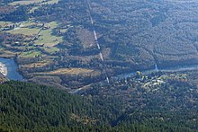
ArlingtonSR 20RockportUnited StatesWashingtonSnohomishSkagitState highways in WashingtonInterstateScenicPre-19641964 renumberingFormerSR 529SR 531state highwayInterstate 5DarringtonArlington HeightsStillaguamish RiverSauk RiverWhitehorse TrailSecondary State Highway 1EConway2014 Oso landslidediamond interchangeStanwoodcity limitsSmokey PointconcurrentlyCentennial TrailSkagit RiverCascade MountainsTraftonU.S. NavyJim Creek Naval Radio Stationcounty governmentrailroad gradetied-arch bridgerock quarry2014 Oso mudslidesubdivisionDarrington RodeoBluegrass festivalmunicipal airportMountain Loop HighwayGranite FallslumberyardMount Baker National ForestSauk-Suiattle Indian Reservationcasinosmoke shoptruss bridgeBurlingtonNorth Cascades National ParkWashington State Department of Transportationstate legislatureNational Highway Systemannual average daily trafficSauk-Suiattle peopleswagon roadNorthern Pacific RailwayPrimary and secondary highwaysPrimary State Highway 1SSH 1YSSH 1A1964 highway renumberingSR 532SilvanaSkagit CountyconfluenceSuiattleBellinghamOso landslidepilot carsState Route 20SeattleVancouverGreat Northern RailwayInternationalSR 534Fir IslandMilltownLake KetchumSnohomish CountyNorth StanwoodVancouver B.C.US 99Sedro-WoolleyOso Mudslide MemorialOkanoganConcurrencyThe Everett HeraldGoogle MapsUSA TodayWashington State Transportation CommissionWashington State UniversityOlympia, WashingtonHistoryLinkUniversity of Texas at AustinWashington State LegislatureWashington State Highway CommissionDepartment of HighwaysIndex, WashingtonWashington House of RepresentativesThe Spokesman-ReviewSR 500SR 501SR 502SR 503SR 504SR 505SR 506SR 507SR 508SR 509SR 510SR 512SR 513SR 515SR 516SR 518SR 519SR 520SR 522SR 523