Washington State Route 504
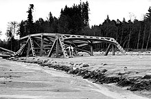
[2] The highway follows a minor stream heading southeast into the wetlands around Silver Lake, where the Mount St. Helens visitor center and Seaquest State Park lie.The company also operates the Charles W. Bingham Forest Learning Center, a museum that overlooks the North Fork Toutle River and also includes a rest area.From the Elk Rock area, the highway forms the northern boundary of the Mount St. Helens National Volcanic Monument and encounters more mountainous terrain that results in several hairpin turns between other scenic viewpoints.SR 504 follows South Coldwater Creek upstream through a narrow valley to its headwaters near Spirit Lake, passing several trailheads, and turns west to continue its ascent.[21] The highway turns east once again near the Loowit Viewpoint and reaches the Johnston Ridge Observatory,[5] the volcano's main visitor center open from spring to autumn and situated at an elevation of 4,314 feet (1,315 m).[33][34] Expanded logging and a planned ski resort on Mount St. Helens hastened the construction of a modern highway linking Spirit Lake to the timberline on the mountain's northern slopes in the 1950s.[35][36] Despite support from the state government, the Forest Service, and Bureau of Public Roads, the highway project was put on hold for several years due to funding shortfalls.The highway would include 23 miles (37 km) of new road built at a higher elevation between Kid Valley and the newly formed Coldwater Lake, crossing over various creeks with ten major bridges.[72] After finding that elk herds were leaving areas with improved highway access, the Forest Service established restricted zones within the national monument that prohibited off-trail hiking, pets, fires, and camping.[89][90] An evacuation of the area was ordered in early October 2004 due to seismic activity, indicating a possible buildup of magma, forcing 2,500 visitors to leave the Coldwater and Johnston centers for several days.[93][94] A mudslide and debris flow, known as the 2023 South Coldwater Slide, occurred on May 14, 2023, destroying the 85-foot (26 m) Spirit Lake Outlet Bridge and severing SR 504 northeast of Johnston Ridge Observatory at milepost 49.Twelve people were airlifted from the area beyond the mudslide; the observatory's seasonal reopening was postponed and the highway east of Coldwater Lake was closed to all traffic.[95][96] WSDOT contractors cleared debris over the highway by July and created a temporary gravel road to access Johnston Ridge for vehicle retrieval and to prepare for reopening in 2024,[97][98] but the interim roadway was washed out in November due to a collapsed culvert caused by heavy rainfall and erosion unrelated to the earlier landslide.[99] WSDOT announced in early 2024 that because of the costs and difficulties in making repairs to the bypass, based on a limited construction window due to weather and elevation as well as the steepness of the terrain, the highway and access to the observatory was to remain closed until 2026.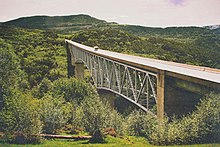

SR 411Castle RockSR 505ToutleJohnston Ridge ObservatoryMount St. Helens NVMUnited StatesWashingtonCowlitzSkamaniaState highways in WashingtonInterstateScenicPre-19641964 renumberingFormerSR 503state highwayNorth Fork Toutle RiverMount St. HelensMount St. Helens National Volcanic MonumentInterstate 5Spirit LakeCowlitz CountyColumbia National ForestGifford Pinchot National ForesttimberlineMay 18, 1980, eruptioninterpretive centersToutle River Sediment Damspur routeI-5 BusinesswinerieswetlandsSilver Lakevisitor centerSeaquest State ParkToutle RiverToledoKid Valleyheliporttruss bridge1980 eruption of Mount St. HelensWeyerhaeuserrest areahairpin turnspartial cloverleaf interchangeColdwater Science and Learning CenterColdwater Lakemilepostavalanches1980 eruptiontrailheadsRocky Mountain elkWashington State Department of Transportationannual average daily trafficstate scenic bywayNational Forest Scenic BywayUnited States Forest ServiceBureau of Public Roadsski resort1964 state highway renumberingWeyerhauserwashed outearthquake swarmroadblockDixy Lee Raymassive eruptionclearanceBailey bridgesFederal Highway AdministrationDavid A. Johnstonshuttle busesWindy Ridgetoll road2023 South Coldwater Slidegravel roadI-5 BLPortlandSeattleSR 504 Spurannual daily trafficThe Daily NewsThe ColumbianGoogle MapsPhiladelphia InquirerNewspapers.comLos Angeles TimesDallas Morning NewsThe Seattle TimesBend BulletinThe OregonianSasquatch BooksThe Oregon Daily JournalMeasuringWorthGross Domestic Product deflatorLongview Daily NewsThe Daily ChronicleWashington State Highway CommissionHistoryLinkAlbany Democrat-HeraldTimes-NewsThe SentinelCorvallis Gazette-TimesEvening TribuneThe New York TimesThe News TribuneJournal and CourierSeattle Post-IntelligencerYakima Herald-RepublicSR 500SR 501SR 502SR 503SR 505SR 506SR 507SR 508SR 509SR 510SR 512SR 513SR 515SR 516SR 518SR 519