Kashmir
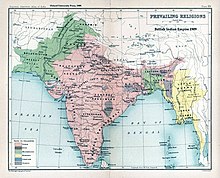
[4] In 1846, after the Sikh defeat in the First Anglo-Sikh War, and upon the purchase of the region from the British under the Treaty of Amritsar, the Raja of Jammu, Gulab Singh, became the new ruler of Kashmir.The Ancient Greeks called the region Kasperia, which has been identified with Kaspapyros of Hecataeus of Miletus (apud Stephanus of Byzantium) and Kaspatyros of Herodotus (3.102, 4.44).Kashmir is called Cachemire in French, Cachemira in Spanish, Caxemira in Portuguese, Caixmir in Catalan, Casmiria in Latin, Cașmir in Romanian, and Cashmir in Occitan.[4] In 1819, the Kashmir Valley passed from the control of the Durrani Empire of Afghanistan to the conquering armies of the Sikhs under Ranjit Singh of the Punjab,[25] thus ending four centuries of Muslim rule under the Mughals and the Afghan regime.[28] The Sikhs enacted a number of anti-Muslim laws,[28] which included handing out death sentences for cow slaughter,[26] closing down the Jamia Masjid in Srinagar,[28] and banning the adhan, the public Muslim call to prayer.[28] Kashmir had also now begun to attract European visitors, several of whom wrote of the abject poverty of the vast Muslim peasantry and of the exorbitant taxes under the Sikhs.Gulab Singh, then a youngster in the House of Jammu, enrolled in the Sikh troops and, by distinguishing himself in campaigns, gradually rose in power and influence.According to The Imperial Gazetteer of India: Gulab Singh contrived to hold himself aloof till the battle of Sobraon (1846), when he appeared as a useful mediator and the trusted advisor of Sir Henry Lawrence.By the first the State of Lahore (i.e. West Punjab) handed over to the British, as equivalent for one crore indemnity, the hill countries between the rivers Beas and Indus; by the second the British made over to Gulab Singh for 75 lakhs all the hilly or mountainous country situated to the east of the Indus and the west of the Ravi i.e. the Vale of Kashmir.[25]Drafted by a treaty and a bill of sale, and constituted between 1820 and 1858, the Princely State of Kashmir and Jammu (as it was first called) combined disparate regions, religions, and ethnicities:[33] to the east, Ladakh was ethnically and culturally Tibetan and its inhabitants practised Buddhism; to the south, Jammu had a mixed population of Hindus, Muslims and Sikhs.[34] That same year, Prem Nath Bazaz, a Kashmiri Pandit journalist wrote: "The poverty of the Muslim masses is appalling."[35] Under Hindu rule, Muslims faced hefty taxation and discrimination in the legal system, and were forced into labor without any wages.[36] Conditions in the princely state caused a significant migration of people from the Kashmir Valley to the Punjab of British India.[34][38] Driven into docility by chronic indebtedness to landlords and moneylenders, having no education besides, nor awareness of rights,[34] the Muslim peasants had no political representation until the 1930s.Pakistan was left with territory that, although basically Muslim in character, was sparsely populated, relatively inaccessible, and economically underdeveloped.India's belated discovery of this road led to border clashes between the two countries that culminated in the Sino-Indian War of October 1962.Jammu and Azad Kashmir lie south and west of the Pir Panjal range, and are under Indian and Pakistani control respectively.Gilgit-Baltistan, formerly known as the Northern Areas, is a group of territories in the extreme north, bordered by the Karakoram, the western Himalayas, the Pamir, and the Hindu Kush ranges.Though these regions are in practice administered by their respective claimants, neither India nor Pakistan has formally recognised the accession of the areas claimed by the other.The Indus valley forms the north and north-eastern portion of the region which include bare and desolate areas of Baltistan and Ladakh.[50] After reaching the end of the Great Himalayan range, the Indus turns a corner and flows southwest into the Punjab plains.Adjacent to these hills are the lofty Great Himalayan ranges (14000–15000 feet) which divide the drainage of the Chenab and Jehlum from that of the Indus.The Pir Panjal Range acts as an effective barrier and blocks these monsoon tracts from reaching the main Kashmir Valley and the Himalayan slopes.There occur semi-deciduous species of Shorea robusta, Acacia catechu, Dalbergia sissoo, Albizia lebbeck, Garuga pinnata, Terminalia bellirica and T. tomentosa and Pinus roxburghii are found at higher elevations.The Blue Pine (Finns excelsa) Zone with Cedrus deodara, Abies pindrow and Picea smithiana occur at elevations between 2,800 and 3,500 m. The Birch (Betula utilis) Zone has Herbaceous genera of Anemone, Geranium, Iris, Lloydia, Potentilla and Primula interspersed with dry dwarf alpine scrubs of Berberis, Cotoneaster, Juniperus and Rhododendron are prevalent in alpine grasslands at 3,500 m and above.[61] In Gilgit-Baltistan the Deosai National Park is designated to protect the largest population of Himalayan brown bears in the western Himalayas.[66] Among the Hindus of Jammu province, who numbered 626,177 (or 90.87% of the Hindu population of the princely state), the most important castes recorded in the census were "Brahmans (186,000), the Rajputs (167,000), the Khattris (48,000) and the Thakkars (93,000).Given its temperate climate, it is suited for crops like asparagus, artichoke, seakale, broad beans, scarletrunners, beetroot, cauliflower and cabbage.The chief trees are deodar, firs and pines, chenar or plane, maple, birch and walnut, apple, cherry.


Kashmir (disambiguation)Kasmir (disambiguation)Kashmarnorthernmost geographical regionIndian subcontinentKashmir ValleyGreat HimalayasPir Panjal RangeJammu and KashmirLadakhAzad KashmirGilgit-BaltistanAksai ChinTrans-Karakoram TractPahalgam ValleyNanga ParbatSikh EmpireRanjit SinghFirst Anglo-Sikh WarBritishTreaty of AmritsarGulab SinghBritish CrownPartition of Indiaprincely stateBritish Indian Empiredisputed territoryPakistanSanskritKashyapamantraSharadaSharada PeethAncient GreeksHecataeus of MiletusStephanus of ByzantiumHerodotusPtolemyAshtadhyayiPāṇiniMahabharataSabha ParvaMatsya PuranaVayu PuranaPadma PuranaVishnu PuranaVishnudharmottara PuranaHuientsangBuddhistOccitanKashmiri languageGovernment of IndiaHistory of KashmirHistory of Gilgit-BaltistanHistory of LadakhHinduismBuddhismKashmir ShaivismRinchan ShahMuslimKashmir SultanateMughal EmpireDurrani EmpireAfghanistanPunjabMughalsAfghanJamia MasjidKashmir shawlsstate of JammuZorawar Singh KahluriaRajouriKishtwarKargilBaltistanJammu and Kashmir (princely state)MaharajaThe Imperial Gazetteer of Indiabattle of SobraonSir Henry LawrenceState of LahoreTibetanbrahminKashmiri PanditsShia IslamGilgit AgencyIndian Rebellion of 1857direct rulesuzeraintyPrem Nath BazazKashmiri PanditKashmir conflictTimeline of the Kashmir conflict1947 Poonch RebellionIndo-Pakistani War of 19471947 Jammu massacres1947 Mirpur massacreHari SinghpartitionIndian EmpireDominion of IndiaDominion of PakistanBurton SteinHyderabadMountbattengovernor-generalplebisciteunion territorieslimited autonomyEncyclopædia BritannicaJhelum valleycommunist revolution of 1949Chinese armyXinjiangSino-Indian Warterritorial disputeSiachen GlacierSaltoro RidgeKarakoramHimalayasHindu KushGilgitKunlunIndo-AryandesertTibetan Plateau