Hull and Barnsley Railway
Following incorporation into the London and North Eastern Railway (LNER), duplicated infrastructure was closed or reduced in function – notably Cannon Street station and the Springhead Locomotive Works.Goole had risen from nothing as a port on the Ouse with the creation of the Knottingley to Goole Canal in 1826 by the Aire and Calder Canal Company; the port, built to generous specifications rapidly gained inward and outward trade – much to the chagrin of Hull, and spurred the development of the extension of the Leeds and Selby Railway to Hull which opened in 1840.A custom-built railway dock and the use of specialised coal barges and unloading facilities, as well as the backing of the Aire and Calder Canal company, made it a very viable competitor to Hull for trade.[4] Additionally, as a competitor to the port of Hull (and equally well placed for European trade), Grimsby began to grow after the 1840s when the Ashton-under-Lyne and Manchester Railway Company built a rail connection, and the Royal Dock was completed in 1852.[6] Despite all this activity, the Dock company was criticised for lack of action – specifically with regard to construction of facilities that would make Hull a foremost coal-exporting port.[7] The situation became untenable when, in 1872, with the NER refusing or unable to transport shipments from the port, deliveries of fish were delayed, and there was a general traffic jam on the rails:[note 3] "..the traffic overwhelmed the powers of the Railway Company; orders for supplies of goods could not be executed, vessels could not receive or discharge cargoes, and the general trade of the port was almost paralysed.[10] As part of the Hull Corporation's involvement with the scheme came the power to veto any joint workings with other railway companies or selling or leasing of land,[11] and despite the opposition of the NER (which had been instrumental in blocking previous plans[7]), the Bill of Parliament was passed with minor alterations on 26 August 1880.[12] The engineer for the main line was William Shelford, whilst Stephen Best was responsible for the Hull section, and Benjamin Baker designed the Alexandra Dock.At Beverley Road, Willerby & Kirk Ella, North Cave and Wallingfen were two-storey buildings with the upper storey accessing the embanked track.[12] At this point the line was almost complete but the subsequent cost cutting meant that the planned grand terminus close to the centre of Hull was never built.Next was a minor goods yard situated at Burleigh Street, then the Foredyke Stream (a drainage canal) and the NER's Hull to Hornsea Line were crossed close together.Westward from Sculcoates goods yard a spur ran backwards to serve Hull Corporation's own electricity power plant (opened 1895[25]).[15][26][27] The station was in one of the most densely populated areas of the town, close to the river and its associated seed oil and varnish works, the buildings being quickly constructed of wood, and surrounded by the company's own coal yards, all of which would have given a poor impression compared with the facilities offered by the NER.[30] From the wye of track at Springbank junctions on the route towards Barnsley the line continued west past the Springhead works.The works were built on green-field land north of the main line outside the then area of urbanisation of Hull, and expanded considerably post opening.[31] At Springhead, south of the main line, there was a through goods loop which also gave access to a considerable area of sidings operated from 1908 onwards.[34] Beyond Springhead the line continued on embanked track towards Willerby and Kirk Ella station, then crossing the small shallow valley at Eppleworth in the foothills of the Yorkshire Wolds by a brick viaduct[img 2] (locally known as "five arches").The line then passed westward through Brierley junction where a southward-turning chord connected with the Dearne Valley Railway on which the H&BR had running powers.[36] In the following years of the 1890s various proposals, including another to merge the NER and HB&WRJR&DCo., and others for expansion of the Hull docks came, but were blocked by one party's interests or another's.From 1907 at Sandholme there were marshalling yards and a turntable, enabling freight trains to be split in two for the steep section towards Hull into the Wolds hills.[44] After exiting receivership, the fortunes of the Hull and Barnsley recovered and it began to pay reasonable dividends on ordinary stock.[8] In 1916 the Hull and Barnsley and Great Central Joint Railway opened, adding to the number of collieries from which the company could transport coal.[52] A total of 186 engines were operated by the Hull and Barnsley Railway, on merging into the NER the locomotives were briefly renumbered by adding 3000 to the original number.[63][note 11] Mainline freight work commonly used the ex Great Central Robinson 2-8-0 locomotives (later classified as LNER Class O4).[64] In 1929 a halt west of Springhead works and sidings was constructed,[note 12] The station was unstaffed, and possibly the smallest in Britain,[66] with two wooden platforms one coach in length each (25 ft).Network Rail, Associated British Ports, Yorkshire Forward, Hull City Council and The Northern Way were involved in funding or supporting the scheme.[90][91][92] In rural areas the embankments and earthworks remain as boundaries between fields, the trackbed west of Weedley Tunnel forms part of the Yorkshire Wolds Way and High Hunsley Circuit walks, and a section of the embankment between Kirk Ella and Hull also carries a footpath whilst a section further west is covered by the B1232 road.It may be safely predicted that before long, and especially if business competition becomes keener, Hull will again realise that emancipation from railway thraldom is a necessity of her existence as a first-class trading port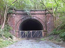


Hampton and Branchville RailroadTrack gaugeHull and Hornsea RailwayHull and Holderness RailwayAlexandra DockVictoria DockRiver HullWilmington BridgeBeverley RoadHull Cannon StreetHull ParagonHull-Selby LineSpringhead HaltWillerby and Kirk EllaLittle WeightonDrewton TunnelSugar Loaf TunnelWeedley TunnelSouth CaveNorth CaveWallingfenSandholmeNorth EastringtonSouth HowdenBarmbyRiver Ouse swing bridgeDrax AbbeySelby to Goole LineCarlton TowersRiver AireH&B & Great Central Joint RlyWakefield, Pontefract & Goole RlyLancashire and Yorkshire RailwayDoncaster-SelbyKnottingley & Goole CanalAskern Branch Line(L&YR)Kirk SmeatonBarnsdale TunnelSouth Yorkshire Junction RailwayWrangbrook JunctionUpton and North ElmsallSwinton & Knottingley Jt RlyWest Riding and Grimsby RailwayHemsworth andSouth KirkbyMoorhouse andSouth Elmsall HaltHickleton and Thurnscoe HaltDearne Valley RailwayMidland RailwayStairfootBarnsleyCudworthThe Hull & South Yorkshire Extension RailwayWath-upon-DearneHull and Barnsley and Great Central Joint RailwayGroupingNorth Eastern RailwayLondon and North Eastern RailwayCannon Street stationEngineer's Line ReferenceAire and Calder Canal CompanyLeeds and Selby RailwayHull and Selby RailwayF. B GrotrianWilliam ShelfordBenjamin BakerLucas and Airdsteam navviesRiplinghamMagnesian LimestoneRailway ManiaMessrs. Handyside of Derbygraving docksHull to Withernsea LineHull to Hornsea LineBeverley and Barmston DrainYorkshire WoldsHull to Selby LineRiver Ouseswing bridge at Long DraxGreat Central RailwayHull and Barnsley and Great Central Joint LineWakefield, Pontefract and Goole RailwayEast Coast Main LineShaftholmeKnottingley and Goole CanalKirk Smeaton stationDenabySwinton and Knottingley joint lineMidlandNorth EasternWest Riding and Grimsby joint lineManchester, Sheffield and LincolnshireGreat CentralGreat NorthernBrierleyMonk Bretton stationCudworth stationSir Edward WatkinNational Radiator companyKing George V DockSpringhead engine shed, HullAlexandra Dock engine shed (Hull)Locomotives of the Hull and Barnsley RailwayLocomotives of the North Eastern RailwayLocomotives of the London and North Eastern RailwayW. KirtleyLondon, Chatham and Dover RailwayMatthew StirlingPatrick Stirling'Stirling Single'brunswick greenultramarinevermilionEarle's shipbuilding of HullKinderdijkB.T. Docks BoardRailways Act 1921Robinson 2-8-0 locomotivesLNER Class O4NER Class P1NER Class YNER Class TNER Class T2