United States Space Surveillance Network
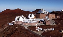
The United States Space Surveillance Network (SSN) detects, tracks, catalogs and identifies artificial objects orbiting Earth, e.g. active/inactive satellites, spent rocket bodies, or fragmentation debris.There is an Image Information Processing Center and Supercomputing facility at the Air Force Maui Optical Station (AMOS).known as the National Space Surveillance Control Center (NSSCC), located at Hanscom Field in Bedford, Massachusetts.In 1960, under Project Space Track, Fitzpatrick and Findley developed detailed documentation of the procedures used at the NSSCC.Early Space Track observations of satellites were collected at more than 150 individual sites, including radar stations, Baker–Nunn cameras, telescopes, radio receivers, and by citizens participating in the Operation Moonwatch program.These systems used modified Schmidt telescopes of great resolution to photograph and identify objects in space.The Baker-Nunn system, like Minitrack, provided little real-time data and was additionally limited to night-time, clear weather operations.The amount of satellite tracking data accumulated required creation or expansion of organizations and equipment to sift through and catalog the objects.The need for real-time detection and tracking information to deal with Soviet satellite launches led on 19 December 1958 to ARPA's implementation of Executive Order 50-59 to establish a spacetrack network.ARDC took up the spacetrack mission in late 1959 and in April 1960 set up the Interim National Space Surveillance Control Center at Hanscom Field, Massachusetts, to coordinate observations and maintain satellite data.The orbital elements and their associated partial derivatives are expressed as series expansions in terms of the initial conditions of these differential equations.Assumptions must be made to simplify these analytical theories, such as truncation of the Earth's gravitational potential to a few zonal harmonic terms.Becoming operational in 1977, Cobra Dane also had a primary mission of monitoring Soviet tests of missiles launched from southwest Russia aimed at the Siberian Kamchatka peninsula.Although limited by their mechanical technology, Pirinclik's two radars gave the advantage of tracking two objects simultaneously in real time.Its location close to the southern Former Soviet Union made it the only ground sensor capable of tracking actual deorbits of Russian space objects.General Electric Heavy Military Electronics Division (HMED) in Syracuse, NY was the prime contractor and Lincoln Laboratory was a subcontractor.After circling the Earth in an apparently dormant state for 9 months, on November 13, 1986 the SPOT 1 Ariane third stage violently separated into some 465 detectable fragments - the most severe satellite breakup yet recorded prior to 2007.[18] Blue Nine refers to a project which produced the AN/FPS-79 Tracking Radar Set built by General Electric, used with the 466L Electromagnetic Intelligence System (ELINT); US Air Force.[19] As of June 23, 2019[update], the catalog built using SSN data listed 44,336 objects including 8,558 satellites launched into orbit since 1957.Ground-based Electro-Optical Deep Space Surveillance, or GEODSS, is an optical system that uses telescopes, low-light level TV cameras, and computers.Moron Optical Space Surveillance (MOSS), a transportable 22-inch aperture telescope that contributed to the GEODSS system was operational at Morón Air Base, Spain 37°10′12″N 5°36′32″W / 37.170°N 5.609°W / 37.170; -5.609 from 1997 to 2012.This sensitivity, and sky background during daytime that masks satellites reflected light, dictates that the system operate at night.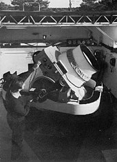


United States space programU.S. Space ForceMercuryGeminiApolloSkylabSpace ShuttleShuttle–MirInternational Space StationCommercial CrewConstellationArtemisLunar GatewayExplorersLarge StrategicLunar OrbiterLunar PrecursorMarinerMars ExplorationNew MillenniumPioneerPlanetary MissionsDiscoveryNew FrontiersPlanetary ObserverRangerSurveyorVanguardVikingVoyagerNASA Astronaut CorpsEastern RangeCape Canaveral Space Force StationKennedy Space CenterWallops Flight FacilityMid-Atlantic Regional SpaceportPacific Spaceport Complex – AlaskaWestern RangeVandenberg Space Force BaseAntaresAtlas VElectronFalcon 9Falcon HeavyLauncherOneMinotaurNew GlennNew ShepardPegasusSpace Launch SystemStarshipVulcan CentaurUnited States Space ForceNational Reconnaissance OfficeUnited States Space CommandDepartment of Energy national laboratoriesFederal Aviation AdministrationOffice of Commercial Space TransportationNational Oceanic and Atmospheric AdministrationNational Environmental Satellite, Data, and Information ServiceOffice of Space CommerceSpace Weather Prediction CenterDepartment of State Office of Space AffairsOffice of Science and Technology PolicyBall AerospaceBigelow AerospaceBlue OriginBoeingFirefly AerospaceLockheed MartinRaytheonRocket LabNorthrop GrummanSierra Nevada CorporationSpaceXUnited Launch AllianceVirgin GalacticVirgin Orbitorbiting Earthsatellitesrocketfragmentation debrisdecaying space objectre-enterEarth's atmospherefalse alarmEarth orbittechnical intelligenceanti-satellite weaponAir Force Maui Optical StationUS governmentHanscom FieldBedford, MassachusettsProject Space TrackOperation MoonwatchIBM 709geocentricephemerisSputnik 1Soviet UnionMinitrackBaker-Nunn satellite tracking camerasRoyal Canadian Air ForceSmithsonian Institution's Astrophysics Observatoryreal-time dataARPA'sMassachusettsLaredo, TexasMoorestown, New JerseyKaena PointAntiguaAscension IslandNaval Station San MiguelKwajalein AtollPave PawsPassive electronically scanned arrayCavalier, NDEglin, FLMaui Space Surveillance SystemGlobus IISan Vito dei Normanni Air StationMIT Lincoln LaboratoryAir Force Space Surveillance Systemvery high frequencyCaliforniaGeorgia