Tendaguru Formation
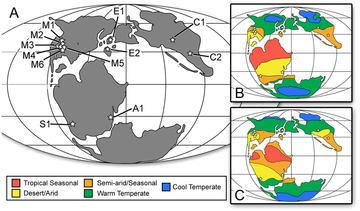
[1] The Tendaguru Formation represents the oldest sedimentary unit in the Mandawa Basin, directly overlying Neoproterozoic basement consisting of gneiss.[8] The main rift phase in present-day southeastern Africa led to the separation of Madagascar and the then-connected Indian subcontinent that happened during the Early Cretaceous.[12] The upper parts of the formation, the Middle Dinosaur and Rutitrigonia bornhardti-schwarzi Members in particular, showed prevailing semiarid conditions with pronounced dry seasons, based on palynologic analysis.Africa became increasingly isolated from most other continents by marine barriers from the Kimmeridgian into the Early Cretaceous, but retained a continental connection with South America.[15] The sedimentary rocks and fossils record a repeated shift from shallow marine to tidal flat environments indicating that the strata of the Tendaguru Formation were deposited near an oscillating strandline which was controlled by sea level changes.[16] The composition of benthic molluscs and foraminifera, euhaline to mesohaline ostracods, and dinoflagellate assemblages indicate marine, shallow water conditions for the Nerinella Member, in particular for the lower part.[19] The coarse-grained sandstone of the lower part of the Indotrigonia africana Member that shows highly variable transport directions is interpreted as deposits of large tidal channels.Stacked successions of trough cross-bedded, medium- to coarse-grained sandstone of the upper part of the Indotrigonia africana Member are interpreted as tidal channel and sand bar deposits.[17] In the Tingutinguti stream section, the Indotrigonia africana Member exhibits several up to 20 centimetres (7.9 in) thick, poorly sorted, conglomeratic sandstone beds.They contain mud clasts, reworked concretions and/or accumulations of thick-shelled bivalves (mainly Indotrigonia africana and Seebachia janenschi), and exhibit megaripple surfaces.[17] The small-scale trough and ripple cross-bedded fine-grained sandstone at the base of the Upper Dinosaur Member is interpreted as tidal flat deposits.[16] The Tendaguru Beds as a fossil deposit were first discovered in 1906, when German pharmacist, chemical analyst and mining engineer Bernhard Wilhelm Sattler, on his way to a mine south of the Mbemkure River in German East Africa in today's Tanzania, was shown by his local staff enormous bones weathering out of the path near the base of Tendaguru Hill, 10 kilometres (6.2 mi) south of Mtapaia (close to Nambiranji village, Mipingo ward, 60 kilometres (37 mi) northwest of Lindi town).


HWL - high water line, LWL - low water line


Stratigraphic range?CallovianHauterivianPreꞒGeological formationNeoproterozoicgneissbasementSandstonesiltstoneconglomeratelimestoneCoordinatesApproximate paleocoordinatesLindi RegionTanzaniaJanenschHennigfossiliferousformationLagerstätteunconformityMiddle JurassicEarly CretaceousOxfordianCalloviansandstonesshalessiltstonesconglomeratesooliticlimestonescoastal plainenvironmentfluviallacustrinetsunamiPaleogeographicalLate JurassicstrataAfricamammaliaformsgeneradinosaurscrocodyliformsamphibiansinvertebratesMorrison FormationKimmeridgeOxford ClaysEnglandSables de GlosArgiles d'OctevilleMarnes de BlévilleFranceAlcobaçaGuimarotaLourinhã FormationsPortugalVillar del Arzobispo FormationShishugouKalazhaShangshaximiao FormationsToqui FormationCañadón Calcáreo FormationBrachiosaurusStegosaurusGiraffatitanKentrosaurusWerner JanenschEdwin Hennigdepositional environmentsfacieslagoonalAlbianAptianBarremianValanginianBerriasianKimmeridgianMid OxfordianEarly JurassicTriassicPaleozoicMesozoicrift basinArcheancrop outMadagascarIndian subcontinentgas fieldsGondwanaLaurasianTethys OceanGlobal sea levelstrenchessand barstempestitestidal flatsbrackishcharophytestrace fossilstidal deltasshoalsconcretionsClassopollisconifersargillaceouscheirolepidiaceanGermanGerman East AfricaWamwera peoplepalaeontologistEberhard FraasMuseum für Naturkunde, BerlinBritish MuseumWilhelm von BrancaGerman EmpireStuttgartGermanyGigantosaurusJanenschiaTornieriaBerlin Natural History MuseumHans Reckprovenance