Mercier, Montreal
Mercier (French pronunciation: [mɛʁsje] ⓘ) denotes the eastern portion of the Mercier–Hochelaga-Maisonneuve borough of the city of Montreal, Quebec.This social transformation was induced by the arrival of large industries in Longue-Pointe and the building of a tramway on Notre-Dame Street.The extension of the metro and elimination of the tramway exacerbated industrial activity, and the remnants of the rural landscape of Longue-Pointe disappeared.[1] Unlike neighbouring Hochelaga-Maisonneuve, it suffered a lesser degree of economic decline and poverty related to the movement of capital and production to Toronto.Other notable features include the Place Versailles shopping mall, the Institut universitaire en santé mentale de Montréal, the Sanctuaire Marie-Reine-des-Coeurs and the historic Chateau Dufresne.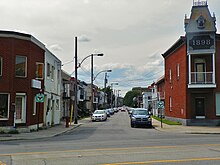

Mercier, QuebecNeighbourhoodLouis-Hippolyte-La Fontaine tunnelMontrealCanadaProvinceQuebecBoroughMercier–Hochelaga-MaisonneuvePostal code(s)Area codes(514) and (438)Honoré MercierPremier of QuebecNotre-Dame StreetExpo 67Autoroute 25Port of MontrealSt. Lawrence Riverpromenade BelleriveHochelaga-MaisonneuveTorontogentrificationPromenade Bellerive ParkPlace VersaillesInstitut universitaire en santé mentale de MontréalChateau DufresneCanadian Armed ForcesCFB MontrealSt-Lawrence RiverMontréal-EstRosemontSaint-LéonardAssomptionCadillacLangelierRadissonHonoré-BeaugrandGreen lineRue SherbrookeLouis-Hippolyte Lafontaine TunnelRue Notre-DameHochelagaHonoré-MercierLa Pointe-de-l'ÎleBourgetAnjou-Louis-RielMontreal city councilCommission scolaire de Montréalaérospatialefoster careEnglish Montreal School BoardVincent Massey CollegiateUrban agglomeration of MontrealCôte Saint-LucHampsteadMontreal EastMontreal WestMount RoyalWestmountWest IslandBaie-D'UrféBeaconsfieldDollard-des-OrmeauxDorvalKirklandL'Île-DorvalPointe-ClaireSainte-Anne-de-BellevueSennevilleBoroughs of MontrealAhuntsic-CartiervilleCôte-des-Neiges–Notre-Dame-de-GrâceL'Île-Bizard–Sainte-GenevièveLachineLaSalleMontréal-NordOutremontPierrefonds-RoxboroLe Plateau-Mont-RoyalRivière-des-Prairies–Pointe-aux-TremblesRosemont–La Petite-PatrieLe Sud-OuestSaint-LaurentVerdunVille-MarieVilleray–Saint-Michel–Parc-ExtensionNeighbourhoodsAhuntsicBenny FarmBois-FrancCartiervilleCentre-SudChinatownCité du HavreCité MultimédiaCôte-des-NeigesCôte-Saint-PaulDowntownFaubourg à m'lasseFaubourg Saint-LaurentGarment DistrictGay VillageGlenmountGolden Square MileGoose VillageGreektownGriffintownHistoric Jewish QuarterL'Île-BizardÎlot-Trafalgar-GleneaglesLittle BurgundyLittle ItalyLittle MaghrebLittle PortugalMile EndMilton ParkMonkland VillageNotre-Dame-de-GrâceNouveau-BordeauxNuns' IslandOld MontrealOverdalePark ExtensionLa Petite-PatriePierrefonds