Côte-des-Neiges
It is located at the geographic centre of the Island of Montreal on the western slope of Mount Royal and is part of the borough of Côte-des-Neiges–Notre-Dame-de-Grâce.In 1876, land owner and farmer James Swail began residential subdivisions on the eastern side of Decelles Avenue.[5] Geographically it was bordered by Decelles Avenue to the north east and the Notre Dame des Neiges Cemetery to the south east, Westmount to the southwest and situated on the confluence of Côte-des-Neiges Road and Queen Mary Road.Up until World War II it remained a village surrounded by working farms to the north and west.With over 100 different ethnic communities, predominantly: Québécois, Filipino, West Indian (Black Canadians), South Asian (Tamils and Bengalis), Jewish, Latin American, Iranian, Chinese, Arab, Vietnamese and most recently Eastern European and African.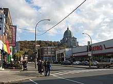

NeighbourhoodMontrealCountryCanadaQuebecBoroughCôte-des-Neiges–Notre-Dame-de-GrâceArea code(s)514, 438Chemin de la Côte-des-NeigeslocallyIsland of MontrealMount RoyalUniversité de MontréalNotre Dame des Neiges CemeteryWestmountCôte-des-Neiges RoadQueen Mary RoadWorld War IISaint Joseph's OratoryQuébécoisWest IndianBlack CanadiansTamilsBengalisCentre de services scolaire de MontréalEnglish Montreal School BoardMontreal Public Libraries NetworkHÉC MontréalPolytechnique MontréalCollège Jean-de-BrébeufSaint-Justine's HospitalJewish General HospitalSt. Mary's HospitalPlaza Côte-des-NeigesOrange LineSnowdonCôte-Sainte-CatherinePlamondonDe La SavaneBlue LineCôte-des-NeigesUniversité-de-MontréalÉdouard-MontpetitAndré BouchardNormand BrathwaiteNapoléon CharbonneauJohn Hamilton FultonKris JosephAlexander JulienVision EternelMarie-Anne-Marcelle MalletDavid Ross McCordPierre NadeauLéa RobackSugar SammyJustin TrudeauSophie Grégoire TrudeauXue YiweiArthur YalePlateau-Mount RoyalWayback MachineThe Globe and MailLa PresseNational PostCBC RadioCanadian Broadcasting CompanyUrban agglomeration of MontrealCôte Saint-LucHampsteadMontreal EastMontreal WestWest IslandBaie-D'UrféBeaconsfieldDollard-des-OrmeauxDorvalKirklandL'Île-DorvalPointe-ClaireSainte-Anne-de-BellevueSennevilleBoroughs of MontrealAhuntsic-CartiervilleL'Île-Bizard–Sainte-GenevièveLachineLaSalleMercier–Hochelaga-MaisonneuveMontréal-NordOutremontPierrefonds-RoxboroLe Plateau-Mont-RoyalRivière-des-Prairies–Pointe-aux-TremblesRosemont–La Petite-PatrieLe Sud-OuestSaint-LaurentSaint-LéonardVerdunVille-MarieVilleray–Saint-Michel–Parc-ExtensionNeighbourhoodsAhuntsicBenny FarmBois-FrancCartiervilleCentre-SudChinatownCité du HavreCité MultimédiaCôte-Saint-PaulDowntownFaubourg à m'lasseFaubourg Saint-LaurentGarment DistrictGay VillageGlenmountGolden Square MileGoose VillageGreektownGriffintownHistoric Jewish QuarterHochelaga-MaisonneuveL'Île-BizardÎlot-Trafalgar-GleneaglesLittle BurgundyLittle Italy