Search for Malaysia Airlines Flight 370
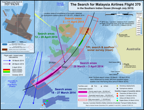
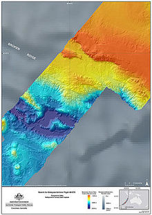
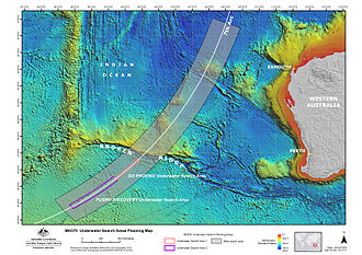
[11] In December 2024, it was reported that Ocean Infinity would resume the search for the missing Malaysia Airlines Flight MH370 under a $70 million 'no find, no fee' agreement with the Malaysian government.[17] The crew was expected to contact air traffic control in Ho Chi Minh City as the aircraft passed into Vietnamese airspace just north of the point where the final verbal communication was made.[20][21] When Malaysia Airlines issued a media statement two hours later, they claimed that they were "working with the authorities who have activated their Search and Rescue team to locate the aircraft".[22] On 9 March, the Chief General of the Royal Malaysian Air Force announced that Malaysia was analysing military radar recordings and that there was a "possibility"[23] that Flight 370 had turned around and travelled over the Andaman Sea.[23][24][25] The search radius was increased from the original 20 nmi (37 km; 23 mi) from its last known position,[26] south of Thổ Chu Island, to 100 nmi (190 km; 120 mi), and the area being examined then extended to the Strait of Malacca along the west coast of the Malay Peninsula, with waters both to the east of Malaysia in the Gulf of Thailand, and in the Strait of Malacca along Malaysia's west coast, being searched.[40] The Malaysian government mobilised its civil aviation department, air force, navy, and Maritime Enforcement Agency; and requested international assistance under Five Power Defence Arrangements provisions and from neighbouring states.[56] The Comprehensive Nuclear-Test-Ban Treaty Organization Preparatory Commission analysed information from its network of infrasound detection stations, but failed to find any sounds made by Flight 370.[59][60] It was also reported that it had been tracked flying at a lower altitude across Malaysia to the Malacca Strait, approximately 500 kilometres (310 mi) from its last contact with civilian radar."[66][71] The following day, satellite operator Inmarsat released a public statement stating that "routine, automated signals were registered" on its network;[72] analysis of these "keep-alive message[s]" that continued to be sent after air traffic control first lost contact could help pinpoint the aircraft's location.[78] Malaysian authorities appealed to the U.S. to share if its Pine Gap satellite ground station or Jindalee (JORN) radar site might have data to help locate the missing aircraft.[84] This remote area, which Australian Prime Minister Tony Abbott described as "as close to nowhere as it's possible to be", is renowned for its strong winds, inhospitable climate, hostile seas, and deep ocean floors.[103] The abundant finds, none confirmed to be from the flight, brought the realisation of the prior lack of surveillance over the area, and the vast amounts of marine debris littering the oceans.[117][118] ADV Ocean Shield, fitted with a TPL-25 towed pinger locator, together with HMS Echo—which carried a "similar device", began searching for pings along a 240-kilometre (150 mi) seabed line believed to be the Flight 370 impact area.The following day, after analysis of data from the last mission, the ATSB announced the search in the vicinity of the acoustic detections was complete and the area could be discounted as the final location of Flight 370.Phoenix planned to use the SLH ProSAS-60 towed synthetic aperture side scan sonar system (rated to 6,000 m depth) to produce a high-resolution image of the ocean floor.[210][further explanation needed] On 13 May 2015, it was announced that Fugro Equator had discovered wreckage of a previously uncharted 19th century cargo ship 4,000 metres underwater, more than 1,000 km off Australia's west coast.[240] Satellite oceanographic data obtained by the CSIRO team revealed that in early March 2014, a ridge of high sea level cut across the main 7th arc search area, producing two prominent westward surface currents in the "intermediate" zone, one at 30°S and one at 35°S.[243] The recovery of the Boeing 777 flaperon at Reunion Island in July 2015 was unexpected by the prevailing drift analyses, as it appeared to arrive far earlier than was predicted for a crash location within the search area.These two data provided concurrence between the July 2015 arrival of the flaperon on Reunion Island, and it having had a source location in the northern end of the original search area.[240] Simulated drift trajectories of a large number of such flaperons were mapped in the analysis, based on them all having a source location within the southern end of the "remaining high probability area" identified in the ATSB First Principles Review (FPR) report.Maritime assets deployed by Ocean Infinity for the search include up to eight autonomous underwater vehicles (AUVs), each able to operate independently within a group, at depths down to 6,000 metres (20,000 ft) without physical tethering to a surface vessel.[272] In March 2022, Ocean Infinity committed to resuming its search in 2023 or 2024, pending approval by the Malaysian government, with two new robotic ships to replace Seabed Constructor.[9] On 8 March 2023, the ninth anniversary of the disappearance of flight MH370, Malaysian Transport Minister Anthony Loke vowed not to "close the book" on MH370, adding that due consideration would be given to future searches if there was "new and credible information" on the aircraft's potential location.Furthermore, the aircraft's flight data recorders were fitted with underwater "pingers", which emit a detectable, pulsating acoustic signal that could have potentially led searchers to their locations."The combination of circumstances necessary to allow [detection of an ocean impact] would have to be very particular", according to Mark Prior, a seismic-acoustic specialist at the Comprehensive Nuclear-Test-Ban Treaty Organization (CTBTO), who also explains that "given the continuing uncertainty regarding the fate of MH370, underwater acoustic data still has the possibility of adding something to the search."[280] When an Airbus A330 hit the Atlantic Ocean at speed of 152 kn (282 km/h; 175 mph), no data relating to the impact was detected in hydroacoustic recordings, even when analysed after the location of that aircraft was known.[16]: 12 Independent analyses of the detections made by ADV Ocean Shield determined that the signals did not match the performance standards of the ULBs attached to the aircraft's black boxes.Sonobuoy drops were carried out at locations along the calculated arc of the final satellite communication with Flight 370 where seafloor depths were considered favourable, near the MV Haixun 01 detections, and along the bearing determined by the Curtin University research team of a possible impact event.[16]: 13 The interim report released by the Malaysian Ministry of Transport in March 2015 mentioned, for the first time publicly, that the battery for the ULB attached to the flight data recorder had expired in December 2012.Two features within the search area—Broken Ridge and the Kerguelen Plateau—potentially contain oil and gas deposits, while a field of manganese nodules—which also contain iron ore, nickel, copper, and cobalt—on the seafloor could also be exploited.


Boeing 777-200ERMalaysia Airlines Flight 370Indian Oceanmarine debrisflaperonRéunion IslandOcean InfinityMalaysiaAustraliaNew ZealandSouth KoreaVietnamUnited KingdomUnited StatesSatellite imageryTomnodcrowdsourcingTimeline of Malaysia Airlines Flight 370TimelineSatellite communications analysisDisappearance theoriesList of missing aircraftKuala LumpurBeijingMalaysia AirlinesKuala Lumpur International AirportBeijing Capital International Airportlocal timeair traffic controlwaypointSouth China SeaGulf of Thailandflight levelACARS protocolarea air traffic controlHo Chi Minh Citysecondary radarArea Control CentreAndaman SeaThổ Chu IslandStrait of MalaccaMalay Peninsulaaviation fuelInternational Charter on Space and Major DisastersPenang IslandMaritime Enforcement AgencyFive Power Defence ArrangementsChina Meteorological Administrationnational space agencyairspacePulau MerantiCyberjayaAir France Flight 447Ministry of DefenceUK Hydrographic OfficeDepartment for TransportMet OfficeComprehensive Nuclear-Test-Ban Treaty Organization Preparatory CommissioninfrasoundMalaysia Airlines Flight 370 satellite communicationsNew ScientistAircraft Communications Addressing and Reporting SystemRolls-Royceflight pathPulau PerakRoyal Malaysian Air ForceThe Wall Street JournalInmarsatNajib RazakKazakhstanTurkmenistanThailandIndonesiaPine GapJindalee (JORN)underwater locator beaconsblack boxesrobotic submarineSumatraAustralian Maritime Safety AuthorityKerguelen IslandsTony Abbottstrong windsP-3 OrionP-8A PoseidonGaofen 1HMAS SuccessFrenchsatellitesThai satelliteRoyal NavyHMS EchoHMS Tirelessflight recordersAustralian Prime MinisterLearmonthADV Ocean Shieldtowed pinger locatorHaixun 01hydrophonesonobuoysside-scan sonarBluefin-21Ocean ShieldWarren TrussAustralian Transport Safety Bureaubathymetric surveyMV Fugro EquatorBroken RidgePetronasPhoenix InternationalYemenia Flight 626Adam Air Flight 574Tuninter Flight 1153synthetic aperture sonarWest Ridgemulti-beam echo soundersCanberratowfishFremantlePhoenix InternationalMV Havila Harmonyrescue and salvage tugespionagesignals intelligenceremotely operated underwater vehicle