Putnam County, Indiana
President Thomas Jefferson chose William Henry Harrison as the governor of the territory, and Vincennes was established as the future capital.The land containing Putnam County was brought into the possession and control of the United States by the Treaty of St. Mary's in 1818 (known as the New Purchase).The act tasked five commissioners to meet in May 1822 at the home of James Athey, a log cabin located at the forks of the Eel River.Records show the court met in session at Athey's cabin in June 1822 and again that September, but the assigned commissioners failed to accomplish their task of selecting a county seat.An incentive was 70 acres of ground donated for the county seat at Greencastle by Ephraim and Rebecca Dukes, who conveyed the corresponding deed in September 1823.The terrain of northern Putnam County is mostly flat; rolling hills become more evident in the center and southwest portions.At the time of settlement, the county was completely tree-covered (poplar, oak, walnut, maple, beech, and hickory),[1] but presently the flat portions have been cleared and used for agriculture; the drainage areas are still wooded.[7] Limestone deposits were extracted beginning in the nineteenth century, and a large iron-ore vein southwest of Cloverdale was discovered in the 1860s.In 1809, what was left of the great Miami Indian Confederacy sold the now southern one-third of Indiana to the US government, when the 10 O'Clock Treaty Line, which passes through Lieber SRA, was laid out.[23] The DePauw Nature Park is a 9-mile (14 km) moderately trafficked loop trail that features a lake, wildlife, and bird-watching.Steep forested sandstone cliffs, lush wooded ravines, and a profusion of ferns and bryophytes characterize the preserve.[25] Located in Putnam County north-northwest of Greencastle, the 371-acre (150 ha) Glenn Flint Lake is home to a relatively new population of game fish, including panfish.The Indiana Department of Natural Resources Division of Fish and Wildlife (DFW) manages the fishery at Glenn Flint.The facility is located 35 miles (56 km) west of Indianapolis and is open for club events and professional team testing.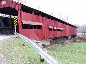

CountyGreencastleIndianaNamed forIsrael PutnamTime zoneUTC−5EasternUTC−4U.S. state2020 United States Censuscounty seatFrench and Indian WarAmerican Revolutionary WarNorthwest TerritoryThomas JeffersonWilliam Henry HarrisonVincennesMichigan TerritoryIllinois TerritoryNative AmericansTreaty of St. Mary'sSullivanDaviessOwen CountyIndiana General AssemblyEel RiverClay CountyParke CountyCecil M. HardenBainbridgeCloverdaleMontgomery CountyHendricks CountyMorgan CountyCagles Mill LakeFillmoreRoachdaleRussellvilleHeritage LakeVan Bibber LakeBarnardBelle UnionBlakesburgBrick ChapelBroad ParkBrunerstownCagle MillCarpentersvilleClinton FallsEdgewood LakeFincastleFox RidgeGrovelandJenkinsvilleKeytsvilleLimedaleManhattanMortonMount MeridianNew MaysvillePleasant GardensPortland MillsPutnamvilleRaccoonReelsvilleVivaliaWestlandClintonFranklinJacksonJeffersonMadisonMarionMonroeRussellWarrenWashingtonInterstate 70U.S. Route 36U.S. Route 40U.S. Route 231Indiana State Road 42Indiana State Road 75Indiana State Road 236Indiana State Road 240Indiana State Road 243Greencastle, IndianaGovernment of IndianaConstitution of IndianaIndiana Codesheriffcoronerauditortreasurerrecordersurveyorcourt clerkPutnam County JailRepublicanDemocraticThird party(ies)2010 United States CensusGermanAmericanEnglishpoverty lineWhite riverCataract FallsShawneePotawatomi10 O'Clock Treaty LineDePauw UniversityIndiana Department of Natural ResourcesIndianapolisGreencastle Community School CorporationGreencastle High SchoolList of Indiana covered bridgesHouck Covered BridgeUS 231Baker's Camp Covered BridgeRolling Stone Covered BridgeCoatesvilleNational Register of Historic Places listings in Putnam County, IndianaPutnam County, New YorkUnited States Census Bureau