November 2020 North American storm complex
The system originated from a weak gulf low off the coast of Texas on November 29, which began to move northeastward onto land the next day.It then began to strengthen, as well as slowing its movement down, resulting in heavy, wind-driven snow for prolonged periods of time in the Ohio Valley.It also triggered a major lake-effect snow event from December 1–2 as the system stalled over Lake Ontario, resulting in additional heavy snowfall.[5] The system reached a peak intensity of 993 millibars (29.3 inHg) at 00:00 UTC on December 1, while two of the low-pressure areas dissipated and the main low stalled out over Lake Ontario.[9] Winter Storm Warnings were issued in parts of Ohio and Pennsylvania, mainly along the shores of Lake Erie due to the potential for heavy snow.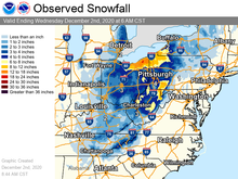
GOES-16storm complexOhio ValleyThompson, OhioEF1 tornadoSouthern United StatesNortheastern United StatesEastern Canada2020–21 North American wintertornado outbreaks of 2020gulf lowLake OntarioSoutheastMid-AtlanticThe Weather Channellow-pressure systemLouisianaAppalachiansWinter Storm WarningsLake ErieWinter Weather AdvisoriesTennesseePennsylvaniaClevelandElnora, IndianaDetroitPittsburghColumbusArab, AlabamaMurfreesboro, TennesseeGatlinburgPigeon ForgeNational Weather ServiceRobbinsville, North CarolinaVerrazano Narrows BridgeMarylandEnhanced Fujita ratingMadisonFloridaGeorgiaEast LakeOdessaPinellasHillsboroughPort DepositWoodlawnBaltimore CornerTemplevilleCarolineMD 313Queen Anne'stornado debris signatureHendersonMontgomeryvilleMontgomeryPA 309US 202Texas RoadhouseStaybridge SuitesCostcoApril 2016 North American storm complexTornado outbreak and floods of April 28 – May 1, 2017Tornado outbreak and blizzard of April 13–15, 2018time zoneCoordinated Universal TimeAon BenfieldWeather Prediction CenterOct 29–30Dec 4–6Dec 14–18Dec 30–Jan 2Jan 25–Feb 4Feb 6–8Feb 13–17Feb 15–20Mar 10–16Mar 16–17Apr 15–17Major snow and ice events in the United States2009–102010–112011–122012–132013–142014–152015–162016–172017–182018–192019–202020–212021–222022–232023–242024–25Feb 27–Mar 7Oct 4–11Jan 6–10Jan 12–13Mar 11–14Feb 11–14Nov 27–28Nov 6–11Mar 15–18Jan 27–28Nov 10–12Dec 25–26Nov 24–30Feb 17–18Mar 18–19Mar 18–22Mar 2–5Dec 11–13Jan 11–13Jan 18–21Mar 6–8Oct 25–30Dec 30, 1963 – Jan 4Jan 27–31Jan 26–27Feb 8–10Mar 5–8Dec 25–28Mar 3–5Jan 9–12Jan 28 – Feb 1