January 2010 North American winter storms
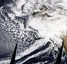
The storms developed from the combination of a strong El Niño episode, a powerful jet stream,[7] and an atmospheric river that opened from the West Pacific Ocean into the Western Seaboard.[4][5][13][14][6] From January 14 to 15, 2010, six extratropical disturbances developed over the north Pacific, within a large trough of low pressure, from the waters south of the Aleutian Islands to the east coast of Japan.[3][22] The storm was steered northeastward by a blocking ridge of high pressure over the Central United States, and made landfall on British Columbia on January 18, before dissipating late that day.[37] The fifth storm then moved northward and weakened,[38] stalling over the northeast Pacific for another several days, before being absorbed into another approaching extratropical cyclone late on January 24.[3] On January 18, 23,000 customers in Southern California lost power for a short time, due to the flooding caused by one of the storms.[50] On January 19, the fourth storm impacted Southern California, bringing flooding and powerful winds to Santee in San Diego County.[51] On the afternoon of January 19, the National Weather Service issued two tornado warnings for San Diego County within hours of each other, as potentially tornadic thunderstorms crossed the area.[52][53] On the morning of January 20, more than 500 homes were evacuated as floods struck multiple regions in California, as up to 6 inches (15 centimeters) of rain fell in the storms that had impacted the state by that point.[57] Freshly-fallen snow blanketed the north side of the San Gabriel Mountains on the morning of January 23, 2010, northwest of Wrightwood, California, after the sixth storm had left.[59] On January 25, Mayor Liz Harris of the City of Big Bear Lake issued a state of emergency, due to the damage caused by the storm.[28] A third tornado was reported by the public in Orange County, with cars overturned on the Pacific Coast Highway and roof damage in the area.
North American blizzards of 2010SuperstormBomb cycloneExtratropical cycloneBlizzardUpper-level lowTornado outbreakMammoth LakesSierra NevadaAlaskaContiguous United StatesCanadaMexicoGreenland2009–10 North American wintertornado outbreaks of 2010Enhanced Fujita scalewinter stormsCaliforniaEl Niñojet streamatmospheric riverWestern SeaboardWestern United StatesSouthwestern United StatestornadoeswaterspoutshurricaneextratropicaltroughAleutian Islands1997–98Pacific NorthwestcycloneGulf of AlaskaBritish ColumbiaWest Coast of the United Statesgale-forceridge of high pressureCentral United Statesbombing outNational Weather ServiceSan Diego CountyOregonNorthern CaliforniaSan FranciscoPineapple ExpressEurekaVenturaSouthern CaliforniaEastern United StatesEastern CanadaHudson BaySanteesinkholelightningSanta Barbaratornado warningsLong BeachAnaheimFlash floodSiskiyou Countypower linesmudslidesdroughtsnowpacksLa Paz County, ArizonaSan Gabriel MountainsWrightwood, CaliforniaCity of Big Bear LakeFlagstaffYavapai CountyWikieupBig Sandy RiverGreat PlainsPennsylvaniaNew JerseySan Diego CountiesHuntington BeachOrange CountyPacific Coast HighwayBlythe, CaliforniaSanta Barbara, CaliforniaWest FresnoFresnoCalifornia State Route 180Isla VistaSeal BeachOrangecatamaransmesonetHuntington Beach PierRipleyBlytheRiversideBrentwoodContra CostaColumbus Day Storm of 1962Los Angeles County flood of 2005January 2008 North American storm complexOctober 2009 North American storm complexGlobal storm activity of 2010Tornadoes of 2010October 2010 North American storm complexDecember 2010 North American blizzardNovember 2011 Bering Sea cycloneJanuary 2013 Northwest Pacific cycloneMarch 2014 North American winter stormNovember 2014 Bering Sea cycloneDecember 2014 North American storm complexJanuary 2015 North American blizzard2017 California floodsLa Niñatime zoneCoordinated Universal TimeAmerican Meteorological SocietyBibcodeMajor snow and ice events in the United States2009–102010–112011–122012–132013–142014–152015–162016–17