February 2023 North American storm complex
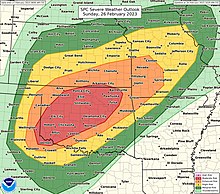
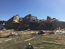
A large and dynamic storm system bought widespread impacts across much of the United States at the end of February 2023.In addition to the severe weather impacts, parts of the Midwestern United States also received periods of heavy snowfall and gusty winds along with ice, causing dozens of accidents, knocking out power, and canceling hundreds of flights.An upper-air disturbance, combined with high-altitude cold air and low pressure, dove southeast from British Columbia into the Western United States on February 21.[16][17][18][19] Weather watches and warnings were issued for snowfall, freezing rain, heavy rainfall, strong winds, and extreme cold.[26] In Arizona, American Airlines issued travel waivers for Flagstaff Pulliam Airport in anticipation of strong winds.[30][31][32] For much of the Portland metro area, the heavy snow came as a surprise with some weather models having struggled to capture eventual location of the system.[36] MAX Light Rail trains and TriMet buses were stalled, causing the delay of passengers arriving to their destinations.[9] Major League Soccer's 2023 season opener on February 25 at the Rose Bowl in Pasadena was rescheduled to July 4 due to the worsening weather.[51] Snow fell at unusually low elevations across Greater Los Angeles, (including in the upper reaches of the Crescenta Valley), the High Desert, and in parts of Northern California such as Eureka, Crescent City, Ukiah, Lakeport, and Cloverdale[52][53][54] and a waterspout moved ashore as an EFU tornado near Redway on February 27.[71][72] Snow stranded drivers and caused difficult conditions for first responders, including a near-miss when a semi almost hit a Wyoming Department of Transportation trooper.[76] The heavy snows, combined with 60 miles per hour (97 km/h) wind gusts, hindered efforts to rescue four people from an earlier avalanche, with only one surviving.[83] To the east, the National Weather Service forecast office in the Twin Cities warned of a "historic" winter storm.[138] On February 26, the greatest risk area was again extended across much of Oklahoma, and the SPC also messaged the potential for a few strong/EF2+ tornadoes across southwestern portions of the state.[139] On the morning of February 26, water vapor imagery depicted a well-defined and compact cold-core low progressing eastward across California and Nevada.As low-level flow increased in advance of the cold-core low, southerly winds allowed that moist airmass to surge rapidly northward throughout the morning and afternoon hours.[142] As the evening approached, supercells developed in the Texas Panhandle, further organizing as a cold front overtook the preexisting dryline and contributed to greater focus for convective activity.[143] To the north, a complex line of storms developed near a 988 millibars (29.2 inHg) surface low in southwestern Kansas, where multiple tornadoes were reported.[144] With time, the originally discrete storms from the Texas Panhandle became intertwined with a solidifying squall line pushing eastward into Oklahoma.Favorable wind shear profiles supported embedded mesovortices and QLCS tornadoes within the line as the storm complex continued east.[146][147] As storms entered eastern Oklahoma, they encountered a less favorable environment and weakened considerably, reducing the threat for severe weather with eastward extent into the pre-dawn hours of February 27, although scattered wind and tornado reports continued all the way into Missouri.[7] Over 100 reports of damaging straight-line wind gusts were received by the SPC, including multiple observations above hurricane-level windspeeds, peaking at 114 mph (183 km/h) in Memphis, Texas.[149] Amtrak's northbound Heartland Flyer was severely delayed due to debris on the tracks caused by the EF2 Norman tornado.An EF0 tornado overturned mobile homes and damaged abandoned farm structures at the Pickaway Correctional Institution near Orient.


Regional Snowfall IndexEF2 tornadoMemphis, TexasWesternSouthernMidwestern United Statestornado outbreaks of 20232022–23 North American winterUnited StatesWestern United StatesPortland, Oregon metropolitan areaGreat PlainsMississippi ValleySt. Louis metropolitan areaTexas PanhandleKansasOklahomawind guststornadoesCheyenne, Oklahomawind gustAugust 2020 Midwest derechoOklahoma City metro areaNormanIllinoisChicago metropolitan areaNortheastern United StatesBritish ColumbiaBay AreaLos Angeles CountySan DiegoVentura CountyFlagstaff Pulliam AirportPortland TimbersMajor League Soccer2023 seasonTroutdaleTigardStaytonCathedral ParkChapman SquareBeavertonPortlandGlenn L. Jackson Memorial BridgeUS 101Portland International AirportNewportMAX Light RailTriMetLincoln CitySan Francisco International AirportManhattan BeachWhittierBoulder CreekHollywood SignYucaipaSR 189CrestlineTujunga2023 season openerRose BowlPasadenaGreater Los AngelesCrescenta ValleyHigh DesertEurekaCrescent CityLakeportCloverdaleRedwayRedondo Beach pierLos Angeles International AirportDisneylandSR 128Yosemite National ParkLos AngelesArizonaCoconino CountyMaricopa CountyNew MexicoGallupAlbuquerqueNevadaStagecoachNational Transportation Safety BoardDenver International AirportVallecito ReservoirLa Plata CountyLa Manga PassWyomingWyoming Department of TransportationCascade RangeNorthern RockiesSeattleSpokaneSanford HealthAvera HealthSioux FallsKristi NoemNational Weather ServiceTwin CitiesMinneapolisSouthwestUnitedAmericanMinneapolis–Saint Paul International AirportWeather Prediction CenterTim WalzNational GuardMinnesota State PatrolMinnesota Department of TransportationBrooklyn ParkCrystalNew HopeLunds & ByerlysCottonwoodJacksonMartinWatonwanGreen Bay–Austin Straubel International AirportRochester, Minnesotajackknifed semi-trucksGreen BayKenoshaMilwaukee Mitchell International AirportMenasha