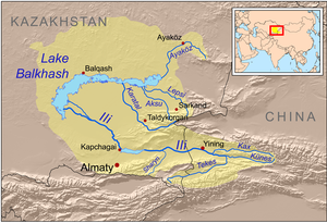
Jetisu
Jetisu (Kazakh: Жетісу, romanized: Jetısu [ʒʲetɘˈsuˑ])[1][2] or Semirechye (Russian: Семиречье, IPA: [sʲɪmʲɪˈrʲetɕje]) is a historical region in Central Asia corresponding to the southeastern part of modern Kazakhstan.In the north, where the province bordered Semipalatinsk, it included the western parts of the Tarbagatai range, the summits of which (3,000 m or 10,000 ft) do not reach the limit of perpetual snow.The remainder of the province consisted of a fertile steppe in the north-east (Sergiopol), and vast uninhabitable sand-steppes on the south of Lake Balkhash.When Dzungar Khanate was conquered by the Qing dynasty in 1755, the area formed part of the Qing dynasty and was under the direct rule of the general of Ili (Chinese: 伊犁將軍, Yīlí jiāngjūn [zh]), headquartered at the fort of Huiyuan (then more often known as Ili or New Kuldja)[16] about 30 km (19 mi) west of Ghulja (Yining).Most of Jetisu was annexed by the Russian Empire from Qing China in 1854,[17] before the outbreak of the Crimean War, which delayed the southern advance.The province was divided into six districts, the chief towns of which were Verny (the capital), Jarkent, Kopal, Pishpek, Przhevalsk and Sergiopol.From 1905, after the Russian-Japanese war and the construction of the Trans-Aral Railway, the settlement of Russian people in the area increased greatly under the guidance of the new Migration Department in St. Petersburg (Переселенческое Управление).Approximately 2,500 Russian settlers are thought to have been killed by the Kazakhs in the violence that followed in Jetisu, and this was followed by equally bloody reprisals against the nomadic population, led by the (all-Russian) workers' & soldiers' Soviets in Tashkent and Verny.


Jetisu (disambiguation)Semirechye OblastSemirechye CossacksSemirechye, Kugarchinsky District, Republic of BashkortostanKazakhromanizedCentral AsiaKazakhstanKyrgyzLake BalkhashJetisu RegionAlmaty RegionDefense Mapping AgencysteppesTian ShanIssyk KulSemipalatinskXinjiangFerganaSyr-daryaAkmolinskDzungarian AlatauAla-TauChimkentAuliye-ataTurkestanSergiopolLake KaindyAlmatyPrzhevalskBishkekIli Kazakh Autonomous PrefectureChu RiverGovernor-Generalship of the SteppesNaryn Riverlongitudinal valleyFergana ValleySyr DaryaIssyk-KulSon-KulChatyr-KulKazakhsRussiansTaranchiUyghursHistory of the central steppeIranianScythiansKhorezmDzungar KhanateQing dynastyChineseHuiyuanGhuljaRussian EmpireCrimean WarTreaty of TarbagataiChinese XinjiangPishpekRussian TurkestanJarkentAscension Cathedral, AlmatyRussian Revolution of 1917agricultureOrchardsBee-keepingRussian-Japanese warTrans-Aral RailwaySt. PetersburgVasile BalabanovAlexander DutovCentral Asian RevoltProvisional GovernmentSovietsTashkentMikhail FrunzeKazakh ASSRSoviet UnionSoviet RepublicKyrgyz ASSRKyrgyzstanOnsu CountyAksu PrefectureKizilsuSapta SindhuIndian subcontinentTurkishPersianMongolianKazakh TVHungarian Academy of SciencesYouTubeOle OlufsenWilliam HeinemannInternet ArchivearticlesHistoryKangjuRouran KhaganateGöktürksKangar unionKimek KhanateKarluksOghuz Yabgu StateXueyantuo KhaganateUyghur KhaganateKyrgyz KhaganateKara-Khanid KhanateMongol EmpireChagatai KhanateGolden HordeWhite HordeUzbek KhanateKazakh KhanateList of Kazakh khansAlash AutonomyKazakh SSRPostalGeographyAktogay CanyonAltay (Altai) MountainsAral Karakum DesertCaspian SeaKazakh SteppeKhan Tangiri ShyngyKyzylkum Desert