Lake Balkhash
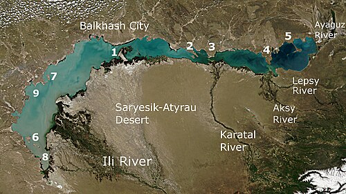
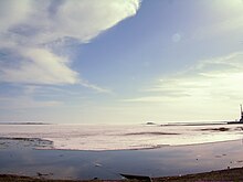
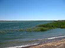
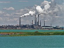
There is concern about the lake's shallowing due to desertification of microclimates and water extraction for multiplied industrial output.The present name of the lake originates from the word "balkas" of Tatar, Kazakh and Southern Altai languages which means "tussocks in a swamp".From the 8th century on, the land to the south of the lake, between it and the Tian Shan mountains, was known in Turkic as Jetisu "Seven Rivers" (Semirechye in Russian).Balkhash lies in the deepest part of the vast Balkhash-Alakol depression, which was formed by a sloping trough between mountains of the Alpine orogeny and the older Kazakhstan Block during the Neogene and Quaternary.Rapid erosion of the Tian Shan has meant the depression subsequently filled with sand river sediments in what is geologically a very short timespan.In ancient times Balkhash was much larger and many lakes in the area were part of it, such as Zhalanashkol, Itishpes, Alakol and Sasykkol.These parts are connected by the Uzynaral Strait (Kazakh: Ұзынарал – "long island") – 3.5 km wide and about 6 metres deep.One extends from the western coast (near Tasaral Island) to Cape Korzhyntubek, while the second lies south from the Gulf Bertys, which is the deepest part of the "half".[14] The western and northern shores of the lake are high (20–30 m) and rocky; they are composed of such Paleozoic rocks as porphyry, tuff, granite, schist and limestone and keep traces of ancient terraces.[19] The river rises in a very long, narrow, high sided valley lined by the Tian Shan mountains and is mainly fed by glacier.Projects were proposed to slow down the changes, such as by splitting the lake in two with a dam, called off as the Soviet Union saw recession, democratisation and secession.[4][11][22] Total losses amounted to 24.58 km3, including The minimal water level of recent decades (340.65 meters AOD) was in 1987, when the filling of Kapshagay Reservoir was completed.Water in the west half is nearly fresh, with the content of total dissolved solids about 0.74 g/L, and cloudy (visibility: 1 metre); it is used for drinking and industry.The east half has less silt in suspension (visibility: 5.5 metres) but resembles oceanic sea water in salinity, with concentration of 3.5–6 g/L.Under water grow two types of Myriophyllum – spiked (M. spicatum) and whorled (M. verticillatum); several kinds of Potamogeton – shining (P. lucens), perfoliate (P. perfoliatus), kinky (P. crispus), fennel (P. pectinatus) and P. macrocarpus; as well as common bladderwort (Utricularia vulgaris), rigid hornwort (Ceratophyllum demersum) and two species of Najas.Oriental bream (Abramis brama orientalis), Aral barbel (Luciobarbus brachycephalus), Siberian dace (Leuciscus baicalensis), tench (Tinca tinca), European perch (Perca fluviatilis), wels catfish (Silurus glanis), osman (Diptychus), Prussian carp (Carassius gibelio) and others.[13][19] Abundant and dense reeds in the southern part of the lake, especially in the delta of the Ili River, served as a haven for birds and animals.Changes in the water level led to the degradation of the delta – since 1970, its area decreased from 3,046 to 1,876 km2, reducing wetlands and riparian forests which were inhabited by birds and animals.Around the 1940s, Canadian muskrat was brought to the Ili delta; it quickly acclimatized, feeding on Typha,[26] and was trapped for fur, up to 1 million animals per year.[20] Balkhash is also the habitat of 120 types of bird, including cormorants, marbled teal, pheasants, golden eagle and great egret; 12 of those are endangered, including great white pelican, Dalmatian pelican, Eurasian spoonbill, whooper swan and white-tailed eagle.[20] In 2005, 3.3 million people lived in the basin of the Lake Balkhash, including residents of Almaty – the largest city of Kazakhstan.The western shore also hosts military installations built during the Soviet era, such as radar missile warning systems.The associated 49.5-MW Kerbulak Hydroelectric Power Plant will partially solve the problem of providing electricity to the southern areas of Kazakhstan and will serve as a buffer for daily and weekly fluctuations in the water level of the Ili River.The conference adopted a resolution and appeal to the government of Kazakhstan and international organizations, suggesting new ways of managing the ecosystems of Alakol and Balkhash basins.[21] At the 2005 International Environmental Forum devoted to Lake Balkhash, Kazakhmys announced that by 2006 it will restructure its processes, thereby reducing emissions by 80–90%.


Lake BaikalKazakhstanEndorheicSalinePrimary inflowsKaratalPrimary outflowsevaporationKazakh15th largest in the worldCentral AsiaBalkhash-Alakol Basinripariansubsurface flowprecipitationXinjiangAral SeastraitfreshwaterBalkhashdesertificationmicroclimatesSouthern Altai languagestussocksChineseTian ShanTurkicSemirechyeRussianMongolssteppeRussian EmpireTreaty of TarbagataiSoviet UnionKaratal RiverAlpine orogenyKazakhstan BlockNeogeneQuaternaryriver sedimentsDzungarian AlatauSasykkolAlakolAral–Caspian DepressionTokrauZhalanashkolItishpessicklehydrographicallyBasaralTasaral IslandPaleozoicporphyrygraniteschistlimestonecoastlineTasaralKorzhyndrainage basinKyrgyzglacierrelief precipitationglacial meltinggroundwaterAyaguzdroughtsKapshagay Hydroelectric Power PlantKapshagay Reservoirtotal dissolved solidscontinentalrelative humidityirradiancewillowriparian forestsPopuluscommon reedS. lacustrisendemicMyriophyllumM. spicatumM. verticillatumPotamogetonP. lucensP. perfoliatusP. crispusP. pectinatusUtricularia vulgarisCeratophyllum demersumPhytoplanktonbiodiversityshellfishcrustaceanschironomidaeoligochaetazooplanktonIli marinkaBalkhash marinkaBalkhash perchTriplophysa strauchiiT. labiataBalkhash minnowcommon carpOriental breamAral barbelSiberian daceEuropean perchwels catfishDiptychusPrussian carppesticidesvertebratesRed BookCaspian tigerwild boarmuskratcormorantsmarbled tealpheasantsgolden eaglegreat egretgreat white pelicanDalmatian pelicanEurasian spoonbillwhooper swanwhite-tailed eagle