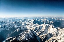
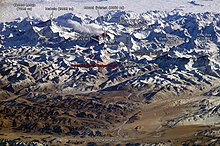
Himalayas

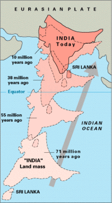
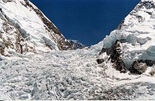
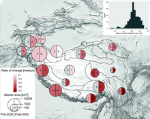
The mountains consist of large glaciers, which are remnants of the last ice age, and give rise to some of the world's major rivers such as the Indus, Ganges, and Tsangpo–Brahmaputra.[7][8] The name of the range is mentioned as Himavat (Sanskrit: हिमवत्) in older literature such as the Indian epic Mahabharata, which is the personification of the Hindu deity Himavan.The Himalayas run as an arc for 2,400 km (1,500 mi) from west-northwest to east-southeast at the northern end of the Indian subcontinent, separating the Indo-Gangetic Plains from the Tibetan Plateau.[20][21] The Sivalik Hills form the lowest sub-Himalayan range and extends for about 1,600 km (990 mi) from the Teesta River in the Indian state of Sikkim to northern Pakistan.The name derives from Sanskrit meaning "Belonging to Shiva", which was originally used to denote the 320 km (200 mi) stretch from Haridwar to the Beas River.The high altitude regions are uninhabitable with few mountain passes inbetween that serve as crossovers with the human settlements in the lower valleys.[32] The Assam Himalaya forms the eastern most sub-section that extends eastward for 720 km (450 mi) from the Indian state of Sikkim through Bhutan and north-east India past the Dihang River to the India-Tibet border.During miocene (20 mya), the increasing collision between the plates resulted in the top layer of metamorphic rocks getting peeled, which moved southwards to form nappes with trenches in between.[34][38] The summit of Mount Everest is made of unmetamorphosed marine ordovician limestone with fossil trilobites, crinoids, and ostracods from the Tethys ocean.[34] The Himalayas and the Central Asian mountain ranges consist of the third-largest deposit of ice and snow in the world, after the Antarctic and Arctic regions.[54] Since the late 20th century, scientists have reported a notable increase in the rate of glacier retreat across the region as a result of climate change.While the mountains were formed gradually, the rivers concurrently cut across deeper gorges ranging from 1,500–5,000 m (4,900–16,400 ft) in depth and 10–50 km (6.2–31.1 mi) in width.[67][74] Due to its location and size, the Himalayas acts as a climatic barrier which affects the weather conditions of the Indian subcontinent and the regions north of the range.The post monsoon season is largely devoid of rain and snow before beginning of cold winters in December-January with intermediate spring before the summer.[79] The effect of Himalayas on the hydroclimate impacts millions in the plains as the variability in monsoon rainfall is the main factor behind wet and dry years.[94] The increased warming and melting of snow is projected to accelerate the regional river flows until 2060 after which it would decline due to reduction in ice caps and glacier mass.The extreme weather events might cause physical harm directly and indirectly due to lack of access and contamination of drinking water, pollution, exposure to chemicals, and destruction of crops, and drought.Tropical and subtropical broadleaf forests are mostly constricted to the high temperature and humid regions in Eastern and Central Himalayas, and pockets of Kashmir in the west.Major vegetation include Juniperus, Rhododendron on rocky terrain facing the Sun, various flowering plants at high elevations, and mosses, and lichens in humid, shaded areas.[74] The Himalayas are home to various medicinal plants such as Abies pindrow used to treat bronchitis, Andrachne cordifolia used for snake bites, and Callicarpa arborea used for skin diseases.The population of the Himalayas has grown considerably over the last five decades from 19.9 million in 1961 with the annual growth rate (3.31%) more than three times higher than the world average (1.1%) during the same period.The major human migration towards the Himalayan region occurred in 2000 BCE when Aryans came from Central Asia and progressively settled along the plains to the south.Various ethnic people such as Ladakhi, Balti, and Dard live on the north of the Great Himalayas along the Indus basin in the Kashmir and Ladakh regions spread across India, Pakistan, and China.People of various ethnicity such as Newar, Tamang, Gurung, Magar, Sherpa, Bhutia, Lepcha, and Kirat, who speak Tibeto-Burman languages, are spread across the mountainous regions of Nepal, Bhutan, and parts of North East India.The Indian state of Arunachal Pradesh along the eastern edge is home to various Tibeto-Burman speaking ethnic groups such as Abor, Aka, Apatani, Dafla, Khamti, Khowa, Mishmi, Momba, Miri, and Singpho, who mostly practice shifting cultivation.The Himalayan region is occupied by people of various religions and several places in the Himalayas are of religious significance in, Bon, Buddhism, Hinduism, Islam, Jainism, and Sikhism.[139][140] In Jainism, Mount Ashtapada of the Himalayan mountain range is a sacred place where Rishabhanatha, the first Jain tirthankara, attained liberation.[144][115] Due to the higher rate of flow of the Himalayan rivers, they have been dammed at multiple places for development of irrigation facilities and generation of hydroelectricity.In the Western Himalays, coal is found in Jammu region, bauxite, copper, and iron ore in Kashmir valley, borax and sulfur in Ladakh, and semi precious stones such as sapphire in Zanskar range.[144] There are a number of hill stations and religious centers on the lower ranges of the Himalayas and hence tourism is an important economic activity in the region.
Political map of the Himalayan region.
Geologic map showing the regions and major features of the Himalayas.
A view of the Western Himalayas .
The 6,000 km-plus journey of the India landmass before its collision with the Eurasian Plate more than 10 mya .
The movement of the Indian plate into the Asian plate makes the region seismically active. Earthquakes in the Himalayan region (1900–2016).
Confluence of the Indus and Zanskar Rivers in the Himalayas.
Bhagirathi , one of the head streams of Ganges at Gangotri .
Map showing various climatic zones in the Indian subcontinent.
Map of India showing the onset of summer and winter monsoon.
Loss of glacier mass in the Himalayas since the 20th century.
Glacial lakes in Bhutan formed by increasing glacier melt, some of which may be prone to dangerous floods.
The Silk Road and connecting routes in the 1st century CE.
The Harmukh mountain, north of Kashmir valley , is sacred in Hinduism .
Taktsang monastery in Bhutan
Terrace farming in the foothills.
Nainital , a hill station in the Lower Himalayas.
Srinagar-Leh highway (NH1) connects the Vale of Kashmir with Ladakh in India.
Kalka-Shimla Railway is one of the two Mountain Railways of India operating in the Himalayan region.
Himalaya (disambiguation)eight-thousandersIndo-Gangetic PlainTibetan plateauGangesYarlung TsangpoBrahmaputraMount EverestElevationCoordinatesHindu KushCountriesAfghanistanBhutanPakistanContinentOrogenyAlpine orogenyRock ageCretaceousCenozoicRock typesMetamorphicsedimentarymountain rangeplainsIndian subcontinentseveral peakshighest mountainsix countriesKashmirKarakoramNanga ParbatIndus riverNamcha BarwaYarlung Tsangpo RiverSivalik HillsLower HimalayasGreat HimalayasTibetan HimalayasformedsubductionIndian tectonic plateEurasian Plateconvergent boundaryseismicallyglaciersice ageworld's major riversTsangpodrainage basinendorheicCentral Asiamonsoonssubtropicalcold and dry desertSouth AsiaIndianTibetanHinduismBuddhismJainismGangkhar PuensumMachapuchareKailashSanskritHimavatIndian epicMahabharataHimavanNepaliBengalisimplified Chinesetraditional ChinesepinyinChineseEmily DickinsonHenry David ThoreauList of Himalayan peaks and passesHimalayan RimIndo-Gangetic PlainsPakistan-administered KashmirTibet Autonomous RegionTeesta RiverSikkimHaridwarBeas RiverChuria RangeLower or Lesser HimalayaGreater HimalayasArunachal PradeshgraniteWestern HimalayaswesterncentraleasternSatlejHimachal PradeshZanskarPir Panjal RangesKumaonUttarakhandnorthern IndiaKali Rivertemperate climateNanda DeviEastern HimalayasNorth East IndianWest BengalTeesta RiversKanchenjungaMakaluAssam HimalayaDihang RiverNathu LaJelep LaGeology of the HimalayasIndia landmassmetamorphic rockplate tectonicscontinental collisionEurasian PlatesJurassic periodTethys OceanGondwanaIndo-Australian plateAustralian Platecontinental crustsoceanic crustsfoldingthrust faultsbasaltEarth's mantlepaleogenesubductmiocenenappesDeccan plateaupleistocenegneissordovicianlimestonetrilobitescrinoidsostracodsShivalik HillsLesser HimalayasKathmanduEarthquakesMain Frontal ThrustMain Boundary ThrustMain Central ThrustArakan YomaMyanmarAndaman and Nicobar IslandsBay of BengalthrustingHimalaya southern frontPodzolicIndus basinShyok RiversLadakhsaline soilalluvial soilsKashmir valleylithosolsIcefallKhumbu GlacierAntarcticArcticSouth ColGangotrilast ice ageKangchenjungaglacier retreatZanskar Riverswater divideLadakh RangeKailasNyenchen Tanglha MountainsLake ManasarovarJhelumChenabSutlejPunjab PlainsIndus DeltaArabian seaBhagirathiGanges-Brahmaputra BasinAlaknandaYamunaRamgangaGhagharaGandakiBagmatiTeestaRaidakGanges-Brahmaputra DeltaGyala PeriIrrawaddy RiverAndaman SeaSalweenMekongYangtzeYellow RiversList of Alpine lakes in IndiaGurudongmar Lakefreshwatersaline lakeslithologyholocenePangong LakeWular LakeTso MoririTso KarNilnagTarsar LakeJammu and KashmirGurudongmarChholhamuTsomgo LakesTilichoPhoksundoGokyo Lakesglacial lake outburst floodEcology of the Himalayaslatitudesub-tropicaltemperatesemi-aridBrahmaputra valleylatent heatcondensessnow lineequatorialNew GuineaRwenzorisColombiaheat islandsamount of heatDarjeelingEverestsnowfallsouth west monsoonTaklamakanIndian Oceanatmospheric pressurethermal loworographic effectCherrapunjiclimate changegrowing seasonlandslidesfloodsglacial lakespermafrostGlobal Southtropical diseasesmalariadenguedrinking waterpollutiondroughtpredatorsconflict with humansParis agreementclimate change mitigationadaptationemissionsrenewable energycrop cyclesdrought resistantcanalsforest firesIndomalayan realmbiodiversityHimalayan subtropical broadleaf forestsHimalayan shrub and meadowsfour typestropical and subtropicalconiferousgrasslandsTropical and subtropical broadleaf forestsEastern and Central HimalayasAngiospermsDipterocarpusCeylon ironwoodIndian horse chestnutlithosolHimalayan subtropical pine forestsHimalayan screw pinebambooWestern Himalayan broadleaf forestssal treesWestern Himalayan subalpine conifer forestsconifersChir pineDeodar cedarblue pinemorinda spruceEastern Himalayan alpine shrub and meadowsWestern Himalayan alpine shrub and meadowsJuniperusRhododendronmosseslichensAbies pindrowbronchitisAndrachne cordifoliasnake bitesCallicarpa arboreaskin diseasesdeforestationSnow leopardHimalayan tahrSouth East AsiaMediterraneangiraffehippopotamusAfricanmammalsIndian elephantIndian rhinocerosAsiatic black bearclouded leopardherbivoresbharalHimalayan serowHimalayan musk deerHimalayan goralbrown bearred pandaHimalayan water shrewGee's golden langurKashmir gray langurmagpiesblack-rumped magpieblue magpietitmicechoughswhistling thrushesredstartsRaptorsbearded vultureblack-eared kiteHimalayan griffonSnow partridgeCornish choughblack-necked cranebar-headed goosereptilesJapalurablind snakesinsectsbutterfliesfresh water fishGlyptothoraxextremophilespidersProtected areas in IndiaProtected areas in NepalProtected areas in PakistanProtected areas in Bhutancritically endangeredhangulbiodiversity hotspotsecoregionsUNESCOWorld Heritage SitesSilk RoadDravidian peopleDravidian languagesAryansHindu literaturePuranasMiddle AgesRajputMughal ruleGurkha kingdomBritish influenceLanguage familiesIndo-EuropeanTibeto-BurmanAustroasiaticDravidianTibetan peopleKashmiri peopleKashmiriVale of KashmirGujjarGaddi peopleGujaripastoralnomadicLadakhiKumaon regionLahul-SpitiPahari peoplePahariTamangGurungSherpaBhutiaLepchaNorth East IndiaKathmandu valleyAnnapurnaApataniKhamtiMishmiSingphoshifting cultivationHarmukhSikhismHindusParvatiSvayambhuLingamAyurvedaasanasSiddha yogaChota Char DhamYamunotriBadrinathKedarnathAmarnath TempleSind ValleystalagmiteAmarnath PeakPashupatinathShaivismMuktinathShakta pithasChar Dham of NepalsaligramaVishnuTaktsangParo TaktsangPadmasambhavaVajrayana BuddhistmonasteriesRishabhanathatirthankaraliberationnirvanaBharataTirthankarasTerrace farmingalluviumFruitscherrywalnutalmondspicesNainitalhill stationirrigationhydroelectricitylivestockgrazingJammu regionbauxitecopperiron oresulfursemi precious stonessapphireZanskar rangegypsumgraphitehill stationstourismmountaineeringSustainable tourismreduction in forest coverfirewoodtimberSrinagar-Leh highwayKalka-Shimla RailwayMountain Railways of IndiaKarakoram HighwayPakistan administered KashmirXinjiang regionHindustan-Tibet RoadIndo-Pakistan borderIndia-China borderShipka PassManali-Leh HighwayKhardung passJammu–Srinagar HighwayPir Panjal RangeEast-West HighwayKathmandu–Terai ExpresswayPokharaArniko HighwayKodari passTribhuvan HighwayIndian Railwaysnarrow gauge railwaymountain railway linesDarjeeling Himalayan RailwayRaxaulAmlekhganjJammu–Baramulla lineKangra Valley RailwayKathmandu airportSrinagar airportTenzing-Hillary AirportParo AirportDaulat Beg OldiWestern HimalayaIndian Himalayan RegionList of Himalayan topicsList of mountains in IndiaList of Ultras of the HimalayasTrekking peakKashmir regionBishop, BarryBritannicaOxford English DictionaryOxford University PressRoshen DalalPenguin BooksBBC NewsDickinson, EmilyThoreau, Henry DavidGeological Survey of IndiaElsevierSpringer GeologyWorld Wide Fund for NatureColumbia UniversityBibcodeNational GeographicAmsterdamGeoJournalReutersIndian Space Research OrganisationGovernment of LadakhGovernment of Jammu and KashmirSpringer NatureGovernment of NepalThe GuardianWorld Food ProgramNature Partner JournalsUniversity of MichiganEncyclopedia of EarthCambridge Scholars PublishingSpringer ScienceGovernment of UttarakhandThe HinduThe Huffington PostThe Times of IndiaUniversity Grants CommissionRoutledgeCambridge University PressCornell University PressGovernment of IndiaOpen UniversitySurvey of IndiaWorld Heritage CommitteeThe History ChannelCambridgeNew YorkBostonHeidelbergLexingtonUniversity Press of KentuckyAitken, BillGansser, AugustoGruschke, AndreasHunt, JohnIsserman, MauriceSwami SundaranandTapovan MaharajTilman, H. W.Wayback MachineBangladeshGeologyIndian plateMain Himalayan ThrustSouth Tibetan DetachmentBlack MountainsDundwa RangeGanesh HimalGurans HimalMahalangur HimalMishmi HillsNalakankar HimalDhauladharDudhatoliGarhwalKishtwar HimalayaMargalla HillsPir PanjalJaintiaLushaiPurvanchalTranshimalayaEight-thousanderAnnapurna ICho OyuDhaulagiri ILhotseManasluShishapangmaUltrasAma DablamBandarpunchDorje LakpaGurla MandhataGyachung KangJomolhariKangtegaKangtoKula KangriLabuche KangLangtang LirungMana PeakNoijin KangsangNuptseTongshanjiabuYangraPassesBanihalBara-lacha laChangla PassKhardung LaKora LaKunzumLipulekhRohtangShipki LaThorong LaUmling LaZoji LaKangraRolwalingAmbulapchaChhotaChumikDakshiniDrang-DrungGomukhKalabalandKangshungKhatlingKhumbuKhumbu IcefallLangtangMachoiNangpaiNgozumpaNupchuPanchchuliPindariRathongRongbukSatopanthShafatSiachenTeesta KhangtseThulagiYamatariMarusudarLidderNeelumPoonchShingoYapolaMarkhaTsarapDibangDihingKamengKolongSankoshSubansiriMandakiniPindarNandakiniDhauligangaRishigangaBhilangnaJahanaviGori GangaShardaAncharBhimtalBhriguBhullatalChanderChandraDashairDehnasarDeoriaDhankarDoditalGadsarGangabalGangapurnaGhadhasaruHokersarHomkundKamrunagKareriKausarKedartalKhajjiarKhanpursarKhushalKrishansarMenmechoMacchialMahakaliManasbalManimaheshMansarMarsarNandanNarayanbaghNaukuchiatalNigeenNundkolPandohPangongPrasharRenukaRewalsarRoopkundRukmaniSamitiSatsarSattalSeruvalsarSheshnagSouth LhonakSurinsarTarsarTso LhamoTsomgoTulianVishansarWaskuraEastern Himalayan subalpine conifer forestsEastern Himalayan broadleaf forestsDehradunDharamshalaManaliMussoorieShimlaSrinagarNimmu–Padum–Darcha roadPath of the ManiChinyalisaurDaporijoKullu-ManaliPakyongPithoragarhGreat Himalaya TrailHimalayan Mountaineering InstituteSnowman TrekKhamti peopleAmarnathChangriKardangSpitukThikseHimalayan DatabaseIndian HimalayasInternational Centre for Integrated Mountain DevelopmentSulaimanToba KakarWestern GhatsAmbanadAnaimalaiBiligirirangaCardamomNilgiriSatmalaSelbariPalaniThirumoorthyTrimbakeshwarEastern GhatsBilgiriBodhamalaiChitteriErramalaGandhamardanGarhjatJavadiKalrayanNallamallaNiyamgiriPachaimalaiPalkondaSeshachalamSimhachalamServarayanSirumalaiVelikondaAravalliSatpuraVindhyaBalochistanChota NagpurDeccanMysorePothoharGanges BasinPunjab PlainSundarbansCoastal IndiaEast CoastCoromandelWest CoastCanaraKonkanMalabarRann of KutchMakranLaccadive SeaAndaman and NicobarLakshadweepMajuliPambanMaldivesSri LankaregionLittoralIslandNorthernNorthwesternNortheasternSouthernSouthwesternSoutheasternGeography of IndiaFossil ParksGeological MonumentsStonesCultureHistoryNational monumentsSacred GrovesLandformsBeachesBordersCoastsDesertExtreme pointsHighest point by statesIslandsMountainsMountain passesRiversValleysVolcanoesWaterfallsRegionsNorth IndiaNorthwestNortheast IndiaEast IndiaSouth IndiaWest IndiaCentral IndiaGeographical regionsEastern Coastal PlainsCircarsHimachalHimadriSivalikThar DesertWestern Coastal PlainsKathiawarSubdivisionsStates and territoriesAutonomous areasDivisionsDistrictsCitiesMunicipalitiesEcologyBiogeographic classificationClimateEnvironmental IssuesForestsProtected AreasBiosphere reservesCommunal forestsConservation areasConservation and community reservesNational parksRamsar SitesReserved and protected forestsTiger reservesWildlife sanctuariesWildlifearticlesBhadrabahuShakya RepublicGautama BuddhaMaya (mother of Buddha)Kirata kingdomYalamberLichchhavi ruleManadevaAmshuvermaBhrikutiAranikoArimallaKhasa kingdomBaise RajyaChaubisi Rajya Newa kingdomsEarly Shah ruleGorkha KingdomPrithvi Narayan ShahUnificationKalu PandeKingdom of NepalMonarchsSino-Nepal WarBhimsen ThapaAnglo-Nepal WarBalbhadra KunwarTreaty of SugauliRana ruleKot massacreJung Bahadur RanaTibetan WarTreaty of ThapathaliLamjang and KaskiTribhuvanNepal–Britain Treaty of 1923Panchayat1951 revolutionPanchayat systemBack to the Village campaignJana Andolan IRoyal massacre2005 coup d'étatCivil warJana Andolan IIGeographyDhaulagiriCities of NepalInner Terai Valleys of NepalSiliguri Corridor (Chicken's Neck)Karnali (Ghaghara)Koshi (Kosi)Narayani (Gandaki)West RaptiEnvironmentPoliticsConstitutionConstituent AssemblyElectionsForeign relationsMilitaryChief of the Army StaffParliamentProvincial assembliesPolitical partiesCommunismHeads of statePresidentVice PresidentPrime MinisterCouncil of MinistersSupreme CourtChief JusticeProvincesRural MunicipalitiesBharatpurBiratnagarBirgunjHetaudaItahariJanakpurKathmandu (capital)LalitpurNepalgunjEconomyAgricultureEnergyChild labourCompaniesSouth Asian Free Trade AreaRupee (currency)SquattingTelecommunicationsTransportWorkforceCuisineDemographicsEducationLanguagesLiteratureGurkhas/GorkhasInternational rankingsNepal AcademyNepal Academy of Fine ArtsPeopleEthnic groupsPublic holidaysReligionChristianityFestivalsDashainMohani SwontiDipankha YatraYomari PunhiGadhimaiBuddha JayantiMaghe SankrantiUdhauliUbhauliGyalpo LhosarTamu LhosarSonam LhosarChhathChasok TangnamChhechuNwaranBratabandha BahraShraddhaAntyestiAbortionWitch-huntsCapital punishmentHealthHuman rightsIntersexHuman traffickingOutlineBibliographyGeography of ChinaAltai MountainsDzungarian AlatauTian ShanBorohoro MountainsTarbagatai MountainsKunlun MountainsAltyn-TaghQilian MountainsHelan MountainsLiupan MountainsQinghai-TibetPamir MountainsArgu TaghYengisogatHoh XilBayan Har MountainsAmne MachinTanggula MountainsHengduan MountainsGaoligong MountainsYunling MountainsAilao MountainsQionglai MountainsDaxue MountainsMin MountainsNortheastGreater KhinganLesser KhinganChangbai MountainsWanda MountainsQian MountainsYin MountainsLang MountainsLüliang MountainsTaihang MountainsZhongtiao MountainsMount TaiTianmu MountainYandang MountainsWuyi MountainsQinlingDaba MountainsDabie MountainsWudang MountainsJingshan MountainsLuoxiao MountainsJiuling MountainsMufu MountainsWugong MountainsHuangshanWuling MountainsXuefeng MountainsCang MountainDaliang MountainsDalou MountainsNanling MountainsJiuyi MountainsYuecheng MountainsLongmen MountainsWestern Mountains