Selbari Range
The mountain range was formed by the same historical events that gave birth to the Western Ghats.Resting on the Deccan Plateau geologically identified as a large igneous province, it consists of solidified Flood basalt dating back to the Cenozoic era.East of this hill is situated the Selbari pass facilitating road communication in the depression caused by the headward erosion across this range by the Salvar nala, a tributary of the Panjhra river of Dhule district.Near the eastern extremity of this range within the district is situated the Galna fort, which has given its name to this line of hills, commanding a pass route from south to north.The Highest list in the Selbari range (excluding Dholbari) is the Mangi-Tungi peak with its higher pinnacle Mangi rising up to 4360 feet.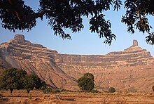

ElevationCoordinatesParent rangeWestern GhatsMountain typeFlood basaltRock typeBasaltNashik DistrictMaharashtraSahyadrisDhule districtMangi-TungiMausam RiverGujaratSalhersecond highest peakSatmala RangeList of mountain peaks of MaharashtraStatesKarnatakaKeralaTamil NaduKongu NaduKonkanMalabarMalenaduNorth MalabarTulu NaduAgasthyamalaiAmbukuthiAnamudiAngindaAnjaneriBaba BudangiriBanasuraBrahmagiriChembraDevar MalaDevimalaDhodapDoddabettaElivai MalaiEravimalaEttina BhujaGangamoolaGopalaswamy BettaIllikkal KalluKalsubaiKarimala GopuramKattumalaKemmangudiKodachadriKodikuthi MalaKolaribettaKottamalaKudremukhKumara ParvataKumarikkal MalaKurumbalakottaMadikeriMahendragiriMahuliMalleswaranMarunthuvazh MalaiMeenuliyan ParaMeesapulimalaMukurthiMullayanagiriNedumparaPadagiriPaithalmalaPerumal MalaiPratapgadPurandarRaigadRajgadRangaswamyRanipuramRatangadSaptashrungiSaputaraSinhagadSisparaSonsogorTadiandamolTaramatiVagamonVandaravuVarayadumottaVavul MalaVelliangiriAmbanadAnaimalaiBiligirirangaCardamomNilgiriSatmalaPalaniThirumoorthyTrimbakeshwarAchankovilAmarjaAmbankadavuAnjarakandi RiverArkavathiAyalurpuzha BangangaBhadraBharathappuzhaBhavaniBindusaraChakraChalakudyChaliyarCherukunnapuzhaCheruthoniChitravathiChittarChulki NalaChulliyarDahisarDaman GangaDandavati DarnaEdamalayar