U.S. Route 25E
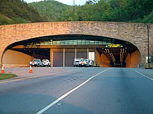
US 25E follows the original pathway of early U.S. pioneer Daniel Boone's Wilderness Road,[4] which contributed to the increased settlement of Appalachia given its access through the rugged Cumberland Gap.[11] US 25E serves as an arterial expressway for long-distance travelers and truckers connecting central Appalachia to the Great Lakes and Eastern Seaboard regions of the U.S. via access to I-75, I-81, and proximity to I-26 and I-40.Since the completion of the Cumberland Gap Tunnel in 1996, upgrades to freeway-grade standards have been planned and constructed for US 25E in both states to improve regional freight movement.[2][18] Entering Hamblen County, US 25E widens to a four-lane divided expressway at I-81 exit 8 and is designated ADHS Corridor S and the Davy Crockett Parkway.It meets SR 160 (Governor Dewitt Clinton Senter Highway), a southern bypass route of Morristown at a partial cloverleaf interchange.North of this interchange, US 25E downgrades to a limited-access four-lane highway along another exurban commercial corridor as it approaches the Hamblen–Grainger county line at the Cherokee Lake impoundment of the Holston River.[19] After this crossing, US 25E enters the town of Bean Station in Grainger County, passing by tourist-based commercial development along a peninsula on the Cherokee Reservoir shoreline near Johnson Ridge.Exiting the tourist area on a rock-fill embankment surrounded by the Cherokee Reservoir shoreline, the highway traverses Collins Ridge, passing by the Crosby Pothole Nature Refuge and is surrounded by Cherokee Reservoir on another rock-fill embankment, before approaching the restricted junctions of Broadway Drive, an old alignment of US 25E, and the northern terminus of SR 375.[2] North of SR 375, US 25E becomes a freeway on a rock cut atop the Richland Knobs' Big Ridge, bypassing Bean Station's central business district to the west.[2] US 25E/US 11W continues northwest, downgrading to a limited-access highway through a minor commercial district on its north and an impounded German Creek on its south in west Bean Station.Three miles (4.8 km) west of Bean Station at its town limits near Briar Fork Creek, US 25E splits from US 11W at an incomplete semi-directional T interchange near the southern base of Clinch Mountain, as US 11W heads westbound along the Richland Valley toward Knoxville.[2][20] North of Thorn Hill, US 25E traverses through the rugged forested Copper Ridge and Broken Valley area, passing by natural water springs and the former Imperial Tennessee marble quarry;[21][22] approaching the pre-stressed box girder Indian Creek bridge.[24] Entering Claiborne County, US 25E winds through the forested and mountainous Caney Valley region and crosses the Norris Lake impoundment of Big Sycamore Creek on a stringer bridge.[2] US 25E then immediately enters the southern city limits of Harrogate after crossing the Powell River on a girder bridge, picking up the Cumberland Gap Parkway designation.US 25E then makes an S-shaped curve, dipping south then turning back northwest as it approaches the city of Barbourville, designed originally as a bypass.US 25E then reunites with US 25W, and the unsuffixed US 25 at a heavily congestion intersection, dubbed by Kentucky transportation personnel as "Malfunction Junction", where US 25 continues north toward London.[28] The route of US 25E was recorded to be first traversed by Native Americans, predominately the Cherokee people, long before the Appalachian region was settled by European pioneers.[33] In 1915, the initial Bean Station Turnpike, along with a southward extension to Morristown and the old Wilderness Road from Cumberland Gap to Corbin, was designated as part of the Dixie Highway, one of the first federal auto trails.[49] In November 1955, KYTC announced a $3-billion (equivalent to $26.6 billion in 2023[46]) 20-year comprehensive plan for statewide roadway improvements, including a proposal for US 25E to become a four-lane median divided limited-access highway for its entire length in the state.[53] In the same year, then Kentucky governor Ned Breathitt announced a two miles (3.2 km) four-lane extension of US 25E, coined the "US 25 Connector", from its terminus from its conjunction into US 25 with US 25W in Corbin, to the under-construction I-75 at a diamond interchange to provide better access to Middlesboro and entering Tennessee.[63][64] In 1969, construction work on a 13-mile (21 km) four-lane bypass around the town of Cumberland Gap from the terminus of US 58 to north of the Powell River bridge in Harrogate started.[79] By 1992, funding for the survey and design of US 25E between Tazewell and the Springdale community in Claiborne County was allocated by Governor Ned McWherter's state budget.The plan, consisting of the construction of twin 4,600-foot-long (1,400 m) tunnels, five miles (8.0 km) of new a four-lane controlled-access US 25E, two interchanges, seven bridges, and the restoration of the Cumberland Gap, was presented with a cost of $265 million (equivalent to $1.39 billion in 2023[46]) and was led by joint effort between the NPS and FHWA.[84] Since the 2000s, congestion from truck and commuter traffic and the issue of access control has brought several projects in Tennessee and Kentucky on upgrading US 25E up to Interstate Highway standards.[12][86][87] Construction work on a new split single-point urban interchange at College Park Drive near WSCC for US 25E started in Morristown on September 2, 2011, by general contractor Summers-Taylor, Inc., of Elizabethton.[89] In February 2018, KYTC started work on a widening and access management project on US 25E between the US 25/US 25W terminus and the intersection at KY 3041 (Corbin Bypass).


US 25US 25WUS 70Newport, TNMorristown, TNUS 11EUS 11WBean Station, TNSR 33Tazewell, TNSR 63Harrogate, TNUS 58Cumberland Gap, TNKY 74Middlesboro, KYUS 119Pineville, KYKY 11Barbourville, KYNorth Corbin, KYKY 770United StatesTennesseeKentuckyJeffersonHamblenGraingerClaiborneLaurelUnited States Numbered Highway SystemSpecialDividedInterstateParkwaysTennessee State Routeseastern branchNewport, TennesseeNorth Corbin, KentuckyInterstate 75Laurel CountyAppalachiaCumberland PlateauRidge-and-ValleyEast TennesseeCorbinMiddlesboroMorristownDaniel BooneWilderness RoadCumberland GapunsignedState Route 32Tennessee State Route SystemDixie Highwayauto trailsU.S. Numbered Highway SystemAppalachian Regional CommissionAppalachian Development Highway SystemCorridor FHarrogatePinevillelimited-access highwaytruck routeFederal Highway AdministrationNational NetworkNational Highway SystemCongressIntermodal Surface Transportation Efficiency ActCumberland Gap Tunnelcivil engineeringGreat LakesEastern Seaboardfreeway-grade standardsNorth CarolinaEast Tennessee Crossing BywayNational Scenic BywayTennessee Department of TransportationKentucky Transportation CabinetNewportCocke CountyDandridgeSR 35US 321Douglas LakeFrench Broad Riverbulb-T beamJefferson CountyBaneberryWhite PineSR 341Walters State Community Collegefour-lane divided expresswayindustrial parkSR 343SR 113Bays MountainfreewaySR 160bypass routepartial cloverleaf interchangecentral business districtCollege Square Mallsingle-point urban interchangeCherokee LakeHolston Riversteel stringer beamBean StationSR 375trumpet interchangesemi-directional T interchangeClinch MountainKnoxvillePoor ValleySR 131Thorn HillTennessee marblepre-stressed box girderClinch Rivergirder bridgeNorris LakeTazewellMaynardvilleSR 345Powell RiverLincoln Memorial University