Sumidero Canyon
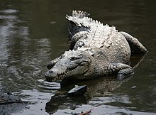
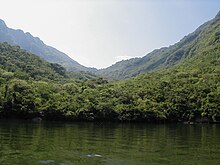
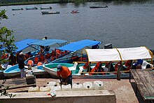
Sumidero Canyon has vertical walls which reach as high as 1,000 metres (3,300 ft), with the river turning up to 90 degrees during the 13-kilometre (8 mi) length of the narrow passage.At the north end of the canyon is the Chicoasén Dam and its artificial reservoir, one of several on the Grijalva River, which is important for water storage and the generation of hydroelectric power in the region.More importantly, the urban areas and logging industries upstream from the canyon have caused serious pollution problems, with up to 5000 tons of solid waste extracted from the Grijalva River each year.[3][4] The process of its formation began about 35 million years ago, making the Sumidero contemporary with the Grand Canyon on the Colorado River.[6][7] These walls expose a long process of disturbance in the Earth's crust with layers of limestone from the Upper Mesozoic, which contain fossils of marine creatures.This geography produces a channel for air flow from northwest to southeast as well as three main climates based on the Köppen system as modified for Mexico.[7] Medium-height deciduous rainforest is mostly located on either side of the canyon, in the north and east of the part towards San Fernando and in the Cañada Muñiz at altitudes of between 150 and 1250 masl.The density of the tree cover in these areas is enough to lower temperatures on the ground in the summer rainy season due to the maximum foliage which occurs at this time.The tree cover is composed of the following species: breadnut (Brosimum alicastrum), guanacaste (Enterolobium cyclocarpum), totoposte (Licania arbórea), jocotillo (Astronium graveolens), cedar (Cedrela odorata), cuaulote blanco (Luehea candida), hormiguillo (Platymiscium dimorphandrum), chicozapote (Manilkara zapota), tempisque (Mastichodendron capiri) and various types of amate fig trees (Ficus spp.).[4] Medium-height perennial rainforest (also known as evergreen cloud forest) exists only in small dispersed patches, mostly on the sides of the canyon in contact with the Grijalva River.It is seen on the north and south sides of the canyon and is usually associated with secondary vegetation such as Tecoma stans, Gliricidia sepium, Plumeria rubra and Acacia collinsii, occupying an area of 6,539 hectares (16,160 acres) in the park.[4] Endangered and threatened species include the spider monkey (Ateles geoffroyi), jaguarundi, ocelot, lowland paca, white-tailed deer, anteater (Tamandua tetradactyla) and buzzard (Sarcoramphus papa).[4] In 2005 and 2006, this agency enlarged the park again with the expropriation of lands in the municipalities of San Fernando and Tuxtla Gutiérrez, adding a total of 1,660 hectares (4,100 acres).The park's borders on this river are marked by the Belisario Domínguez Bridge, over which the Pan-American Highway runs, in the south and the Chicoasén Dam, 35 kilometres (22 mi) to the north.[3][9] The rest of the park's borders extend into the municipalities of Tuxtla Gutiérrez, Chiapa de Corzo, Osumacinta and San Fernando.There are eight ejidos which border the parks and whose activities directly affect it: San Antonio Zaragoza, Venustiano Carranza, Francisco Sarabia, Gabriel Esquinca, Benito Juárez, Osumacinta, El Palmar, 16 de Septiembre and Nuevo Bochil.[17] Via the Grijalva River, the wastewater of about 552,000 people in seventeen municipalities finds its way through the canyon according to park director Edda González del Castilla, with most coming from Tuxtla Gutiérrez, Chiapa de Corzo, Berriozábal and Chicoasén .[13] The most obvious pollution is garbage, especially plastic containers, which mostly comes from area homes and businesses tossed onto the ground or in streams, especially from Chiapa de Corzo and Tuxtla Gutiérrez due to the lack of environmental awareness according to Conanp.[6] While bottles and other plastic are what the casual visitor generally notices, other indicators include the overgrowth of water lilies (due to high levels of fecal matter) and dead animals.[18][20] Somewhere between 80 and 90% of the waste solids found in the river is branches, wood, rocks, sediment and other debris from legal and illegal logging, which cause deforestation .[22] In May 2011, the Fédération Internationale de Natation decided cancel its annual swim marathon in the canyon as they claimed that pollution levels in the river posed a risk to swimmers’ health.[6][25] Much of the daily effort is undertaken by workers with the Comisión Nacional de Áreas Naturales Protegidas (CONANP) and the Secretariat of Tourism in Chiapas, which extract twelve tons of garbage from the Grijalva river each day.[6] This seasonal effort has included local police, civil protections agencies, social organization, the army and individual volunteers.[15] Mexico's federal environmental agency, the Secretaría de Medio Ambiente y Recursos Naturales (Semarnat) states that it cannot get involved in the situation as it is the municipalities that have the responsibility for disposing of trash appropriately.[21] During vacation times, the park may be visited by anywhere from 1,000 to 7,000 people per day, who either enter by car to go to the lookout points or by boat from Chiapa de Corzo.[4] Most of these boat tours operate out of Chiapa de Corzo and run along the river to the Chicoasén Dam for a distance of about 30 kilometres (20 mi).[4][27] As they take visitors from Chiapa de Corzo or Tuxtla Gutiérrez through the canyon and to the dam, they provide environmental, historical and cultural information.Colors of Chiapas is a small museum which exhibits the traditional dress and native musical instruments of the state's indigenous peoples.[4] The Sumidero Canyon National Park is defined on the north end of the river by this dam and the Belisario Domínguez Bridge on the south.In 1960, an expedition of soldiers from the Mexican army, nicknamed the "red handkerchiefs" succeeded into crossing through the canyon by boat over twenty km.


IUCN categorynational parkChiapasTuxtla Gutiérrez, ChiapasComisión Nacional de Areas Naturales ProtegidasSecretaría de Educación PúblicaRamsar WetlandSpanishcanyonChiapa de CorzoMexicoGrand CanyonArizonaGrijalva RiverNational Commission of Protected Natural AreasdeciduousrainforestChicoasén DamTuxtla GutiérrezloggingColorado RiverCuchumatanesGuatemalaTabascoUsumacinta RiverMesozoiccofferdamCentral American river turtleAmerican crocodilemagnesiumpotassiumVirgin of GuadalupestalactiteSeven New Natural Wonders of the Worldabove sea levelKöppen systemprecipitationFabaceaeAsteraceaeOrchidaceaeEuphorbiaceaeConvolvulaceaeCactaceaebasaltgraniteBrosimum alicastrumEnterolobium cyclocarpumAstronium graveolensCedrela odorataManilkara zapotaEpiphytesBromeliaceaecactusAcanthocereusillegal loggingcloud forestOpuntiaStenocereusCephalocereusAlvaradoa amorphoidesBursera simarubaBursera bipinnataCochlospermum vitifoliumPiscidia piscipulaSwietenia humilisAcacia collinsiiPseudobombax ellipticumPine–oak forestsSoyalóQuercus acutifoliaMaxillariaLycasteCattleyaLaeliaTecoma stansGliricidia sepiumPlumeria rubraSecretaría de Agricultura y Recursos HidráulicosCrocodylus acutusYucatán banded geckogreat curassowDendrocygna autumnalisEgretta caeruleaEgretta thulaTachybaptus dominicusCoragyps atratusAteles geoffroyijaguarundiocelotlowland pacawhite-tailed deerTamandua tetradactylaSarcoramphus papaArtibeus jamaicensisPeromyscus mexicanusRamsar ConventionSan FernandoPan-American HighwayOsumacintaejidosBerriozábalChicoasénSabinal Riverwater liliesdeforestationVilla CorzoagrochemicalsFédération Internationale de NatationecotourismPalenqueMexican handcrafts and folk artherpetariumrappellingspelunkingbase jumperenergy drinkmegawattsNicaraguaParaguaySpanish conquestDiego de MazariegosTzotzil peoplesMexican armyPre Classic periodRamsarNational parks of Mexico