Santa Barbara, California
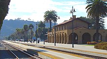
[12] In addition to being a popular tourist and resort destination, the city has a diverse economy that includes a large service sector, education, technology, health care, finance, agriculture, manufacturing, and local government.[19] The most dramatic event of the Spanish period was the powerful 1812 earthquake, and tsunami, with an estimated magnitude of 7.1, which destroyed the Mission as well as the rest of the town; water reached as high as present-day Anapamu Street, and carried a ship half a mile up Refugio Canyon.Santa Barbara fell bloodlessly to a battalion of American soldiers under John C. Frémont on December 27, 1846, during the Mexican–American War, and after the Treaty of Guadalupe Hidalgo in 1848 it became part of the expanding United States.[27] Wood construction replaced adobe as American settlers moved in; during the Gold Rush years and following, the town became a haven for bandits and gamblers, and a dangerous and lawless place.Charismatic gambler and highwayman Jack Powers had virtual control of the town in the early 1850s, until driven out by a posse organized in San Luis Obispo.The building of Stearns Wharf in 1872 enhanced Santa Barbara's commercial and tourist accessibility; previously goods and visitors had to transfer from steamboats to smaller craft to row ashore.In 1887 the railroad finally went through to Los Angeles, and in 1901 to San Francisco: Santa Barbara was now easily accessible by land and by sea, and subsequent development was brisk.Begun as a single mule-drawn line from the waterfront pier to the Arlington Hotel, over the decades it was incrementally expanded, later electrified, and operated until its closure in June 1929.Production at Summerland had ended, Elwood was winding down, and to find new fields oil companies carried out seismic exploration of the Channel using explosives, a controversial practice that local fishermen claimed harmed their catch.Approximately 100,000 barrels (16,000 m3) of oil surged out of a huge undersea break, fouling hundreds of square miles of ocean and all the coastline from Ventura to Goleta, as well north facing beaches on the Channel Islands.Many "clean" industries, especially aerospace firms such as Raytheon and Delco Electronics, moved to town in the 1950s and 1960s, bringing employees from other parts of the U.S. UCSB itself became a major employer.[44][45] When voters approved connection to State water supplies in 1991, parts of the city, especially outlying areas, resumed growth, but more slowly than during the boom period of the 1950s and 1960s.[50] Because the city lies along the ocean and parallel to the predominant westerly winds, sideshore and light onshore breezes moderate temperatures resulting in warmer winters and cooler summers compared with places farther inland.[65] The Santa Ynez Mountains to the north of the city consist of multiple layers of sandstone and conglomerate units dating from the Jurassic Age to the present, uplifted rapidly since the Pliocene, upended, and in some areas completely overturned.Rapid uplift has given these mountains their craggy, scenic character, and numerous landslides and debris flows, which form some of the urban and suburban lowland area, are testament to their geologically active nature.Aerospace and defense companies such as Alliant Techsystems, Channel Technologies Group, FLIR Systems, and Raytheon have major operations in the area.Annually over the Memorial Day weekend, there is a chalk-art festival known as I Madonnari, with ephemeral works of art created on the asphalt in front of the mission, and food stalls set up and music.[102] The Santa Barbara County Courthouse, a red tiled Spanish-Moorish structure, provides a view of the downtown area from its open air tower.The Presidio of Santa Barbara, a Spanish military installation and chapel built in 1782, was central to the town's early development and colonial roots.[108] It is a colorful themed parade put on by local residents, and follows a route along State Street for approximately one mile, ending at Alameda Park.The Santa Barbara Museum of Art (SBMA), located on State Street, features nationally recognized collections and special exhibitions of international importance.Two open air museums here are Lotusland and Casa del Herrero, exemplifying the American Country Place era in Santa Barbara.The Reagan Ranch Center is a three-story museum and gallery operated by Young America's Foundation, next to the Amtrak Station on Lower State Street.[113] Nite Moves is a popular local 5k race, with an optional ocean swim portion, open to all ages and held on Wednesday evenings from May to the end of August.The late Bruce Brown's cult classic documentary, The Endless Summer, put surfing on the map, and he was often seen around town prior to his death in December 2017.[citation needed] Santa Barbara has many parks, ranging from small spaces within the urban environment to large, semi-wilderness areas that remain within the city limits.The California Lutheran University-operated NPR station KCLU (102.3 FM, 1340 AM), based in Thousand Oaks in Ventura County, also serves Santa Barbara and has reporters covering the city.Santa Barbara is bisected by U.S. Route 101, an automotive transportation corridor that links the city to the rest of the Central Coast region, San Francisco to the north, and Los Angeles to the southeast.A bike path and route connects the University of California, Santa Barbara to the downtown area, passing through Goleta and Hope Ranch.In 2009, the Santa Barbara-Santa Maria-Goleta metropolitan statistical area (MSA) ranked as the sixth highest in the United States for percentage of commuters who biked to work (4 percent).


Santa Barbara County, CaliforniaSanta Barbara IslandSanta Barbara County wineMission Santa BarbaraSanta Barbara County CourthousePresidio of Santa BarbaraSanta Barbara CountyCaliforniaUnited StatesCountySanta BarbaraIncorporatedNamed forSaint BarbaraCouncil–managerState SenatorMonique LimónCA AssemblyGregg HartU.S. Rep.Salud CarbajalTime zoneUTC−8Pacific Time ZoneUTC−7ZIP CodesArea codeFIPS codeSpanishcounty seatWest Coast of the United StatesSanta Ynez MountainsMediterranean2020 U.S. censusUniversity of California, Santa BarbaraSanta Barbara City CollegeWestmont CollegeAntioch University Santa BarbaraSanta Barbara Municipal AirportAmtrakPacific SurflinerSan DiegoSan Luis ObispoU.S. Highway 101Los AngelesSan FranciscoLos Padres National ForestChannel Islands National ParkChannel Islands National Marine SanctuaryHistory of Santa Barbara, CaliforniaSpanish EmpireFirst Mexican EmpireUnited Mexican StatesPaleoindianClovisArlington Springs ManChumashJuan Rodríguez CabrilloKingdom of SpainSanta Barbara ChannelSebastián VizcaínoChannel IslandsexpeditionGaspar de PortolàJuan CrespiFelipe de NevePresidioindigenous peoplesCatholicismFermín LasuénJunipero Serrasmallpoxnatural immunityJosé de la Guerra y NoriegaGuerra family of CaliforniaCalifornio1812 earthquaketsunamiSanta Barbara Mission Archive-LibraryMexican War of IndependenceCarrillo family of Californiasecularization of the Missions in 1833Richard Henry Dana Jr.cultureTwo Years Before the MastAmerican soldiersJohn C. FrémontMexican–American WarTreaty of Guadalupe HidalgoConquest of CaliforniaGold Rush yearshighwaymanJack PowersCivil WarStearns WharfsteamboatsCharles NordhoffArlington Hotelsystem of street railwaysPeter J. BarberSummerland Oil Fielddrilling offshoreAmerican Film Manufacturing CompanyHollywoodLoughead Aircraft CompanyseaplanesLockheedearthquake of June 29, 19251906 San Francisco quakeSpanish Colonial stylePearl ChaseMarine Corps Air Station Santa BarbaraNaval Reserve Center Santa BarbaraVandenberg Space Force BasePacific Theatrelobbed 16 shellsEllwood Oil Fieldbombardment of OrleansWorld War IHighway 101Lake Cachumablowout at Union Oil's Platform ADos Cuadras FieldNational Environmental Policy Acturban sprawlLos Angeles basin