Derbyshire
The north and centre of Derbyshire are hilly and contain the southern end of the Pennines, most of which are part of the Peak District National Park.[5] The area that is now Derbyshire was first visited, probably briefly, by humans 200,000 years ago during the Aveley interglacial, as shown by a Middle Paleolithic Acheulean hand axe found near Hopton.The varied landscapes within Derbyshire have been formed mainly as a consequence of the underlying geology, but also by the way the land has been managed and shaped by human activity.The oldest rocks occur in the northern, more upland half of the county, and are mostly of Carboniferous age, comprising limestones, gritstones, sandstones and shales.[19] Some areas of the White Peak exhibit contemporaneous basalt flows (e.g. Ravens Tor at Millers Dale), as well as subsequent dolerite sill intrusion at a much later stage (e.g. near Tideswell Dale),[20] whilst mineralisation of the carboniferous limestone in a subsequent period created extensive lead and fluorite deposits which have formed a significant part of Derbyshire's economy, as did coal mining.[21] The more recent river gravels of the Trent valley remain a significant extractive industry today in south Derbyshire, as does the mining of limestone rock in central and northern parts of the county.[22] Coarse sandstones were once extensively quarried both for local building materials and for the production of gritstone grinding wheels for use in mills, and both former industries have left their mark on the Derbyshire landscape.[24]: 314 For the purposes of protecting and recording the county's most important habitats, Derbyshire has been split into two regions, each with its own Biodiversity Action Plan (BAP), based around National Character Areas.[28] Since 2002, the county flower for Derbyshire has been Jacob's-ladder (Polemonium caeruleum), a relatively rare species, and characteristic of certain limestone dales in the White Peak.The Dark Peak is marked by heathlands, bogs, gritstone edges and acid grasslands containing relatively few species, with plants such as heather (Calluna vulgaris), crowberry (Empetrum nigrum), bilberry (Vaccinium myrtillus) and hare's-tail cotton grass (Eriophorum vaginatum) being dominant on the high moors.[24]: 6 The dales of the White Peak are known for habitats such as calcareous grassland, ash woodlands and rock outcrops in all of which a much greater richness of lime-loving species occurs than elsewhere in the county.Specialised communities of plants occur on former lead workings, where typical metallophyte species include spring sandwort (Minuartia verna), alpine penny-cress (Thlaspi caerulescens) (both known locally in Derbyshire as Leadwort), as well as mountain pansy (Viola lutea) and moonwort (Botrychium lunaria).[31][32] Botanical recording in the UK predominantly uses the unchanging vice-county boundary system, which results in a slightly different map of Derbyshire from the modern geographic county.The limestone outcrops in the central area led to the establishment of large quarries to supply the industries of surrounding towns with lime for building and steelmaking, and latterly in the 20th-century cement manufacture.Derbyshire's relative remoteness in the late 18th century and an abundance of fast-flowing streams led to a proliferation of the use of hydropower at the beginning of the Industrial Revolution, following the mills pioneered by Richard Arkwright.Derbyshire has been said to be the home of the Industrial Revolution, and part of the Derwent Valley has been given World Heritage status in acknowledgement of this historic importance.[37] Although Derbyshire is in the East Midlands, some parts, such as High Peak (which incorporated former areas of Cheshire after boundary changes in 1974), are closer to the northern cities of Manchester and Sheffield and these receive services more affiliated with northern England; for example, the North West Ambulance Service, Granada Television and United Utilities.Outside the main city of Derby, the largest town in the county is Chesterfield.[56] The western area of the High Peak (Buxton, Glossop, New Miils and Chapel-en-le-Frith) is covered by BBC North West from Winter Hill and ITV Granada, both based in Salford.The county has numerous rugby union clubs, including Derby, Chesterfield Panthers, Matlock, Ilkeston, Ashbourne, Bakewell and Amber Valley.It offers Peak District scenery such as Mam Tor and Kinder Scout, and more urban attractions such as Bakewell, Buxton and Derby.[62] In the north of the county, three large reservoirs, Howden, Derwent and Ladybower, were built in the early part of the 20th century to supply the rapidly growing populations of Sheffield, Derby and Leicester with drinking water.The moorland catchment area around these is part of the Peak District National Park and extensively used for leisure pursuits such as walking and cycling.[63] It consists of a white-bordered dark green cross encompassing a golden Tudor rose (a historical symbol of the county) all set in a blue field.The blue field represents the many waters of the county, its rivers and reservoirs, while the cross is green to mark the great areas of countryside.[73] Lair's opening title sequence and primary story locations occur in and around Thor's Cave, part of the Peak District, River Manifold valley.


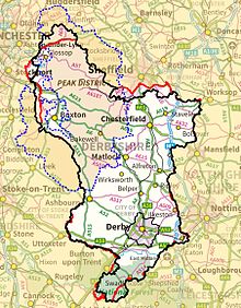
Clockwise from top left:
North West Green Belt
South and West Yorkshire Green Belt
Nottingham and Derby Green Belt
Burton upon Trent and Swadlincote Green Belt
West Midlands Green Belt
Stoke-on-Trent Green Belt


Derbyshire (disambiguation)Non-metropolitanceremonial countyPeak DistrictHathersageDerby CathedralMasson MillSir Richard ArkwrightSovereign stateUnited KingdomConstituent countryEnglandRegionEast MidlandsAncientTime zoneList of MPsDerbyshire ConstabularyCeremonial countyLord LieutenantHigh Sheriff21st of 48Non-metropolitan countyDerbyshire County CouncilControlConservativeMatlock13th of 2112th of 21GSS codeDistrictsHigh PeakDerbyshire DalesSouth DerbyshireErewashAmber ValleyNorth East DerbyshireChesterfieldBolsoverGreater ManchesterWest YorkshireSouth YorkshireNottinghamshireLeicestershireStaffordshireCheshireSwadlincoteunitary authorityEast Midlands Combined County AuthorityPenninesNational ParkKinder ScoutRiver DerwentRiver TrentCoton in the ElmsHistory of DerbyshireinterglacialMiddle PaleolithicAcheuleanHoptonUpper PaleolithicNeolithicMesolithiclimestoneArbor Lowchambered tombsMinninglowFive WellsYoulgreavehenge monumentBronze Agehut circlesSwarkestoneRoman conquest of Britainlead oreBroughHope Valleynear GlossopBuxtona fortLittle ChesterMerciaReptonNorman Conquestforest lawsForest of High PeakWilliam PeverelHenry de FerrersDuffield FrithDuchy of LancasterForest of East DerbyshireHenry IIEdward ITrent ValleyDove ValleyDerwent ValleyBleaklowAxe Edge MoorNational Character AreasDark PeakWhite PeakLeicestershire & South Derbyshire CoalfieldCarboniferouslimestonesgritstonessandstonesshalesMagnesian LimestonemudstonesQuaternaryMam TorAlport CastlesCastletonDinantianDerbyshire DomeNamurianWestphalianMercia Mudstone GroupSherwood SandstonesTicknallWest Midlands Green BeltStoke-on-Trent Green Beltgreen beltsNorth West Green BeltSouth and West Yorkshire Green BeltNottingham and Derby Green Belt