Contiguous United States
[1][2] The term excludes the only two non-contiguous states, which are Alaska and Hawaii (they are also the last two states to be admitted to the Union), and all other offshore insular areas, such as the U.S. territories of American Samoa, Guam, the Northern Mariana Islands, Puerto Rico, and the U.S. Virgin Islands.[citation needed] Residents of Alaska, Hawaii and off-shore U.S. territories have unique labels for the contiguous United States because of their own locations relative to them.Alaska is the northwest extremity of the North American continent, separated from the U.S. West Coast by the Canadian province of British Columbia.[23][24] Puerto Rico is an unincorporated territory of the United States located in the northeast Caribbean Sea, approximately 1,000 miles (1,609 km) southeast of Miami, Florida.[25] The U.S. Virgin Islands is a U.S. territory located directly to the east of Puerto Rico in the Caribbean Sea.[29] Apart from off-shore U.S. islands, a few continental portions of the contiguous United States are accessible by road only by traveling through Canada.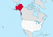
United StatesAlaskaHawaiiU.S. statesDistrict of ColumbiaNorth Americacontiguousadmitted to the Unioninsular areasU.S. territoriesAmerican SamoaNorthern Mariana IslandsPuerto RicoU.S. Virgin IslandsBritish ColumbiaCaribbeanPacificgreat-circleFloridaState of Washingtonlist of countries and dependencies by areaRussiaCanadaBrazil2020 U.S. censusContinental shelf of the United StatesUnited States Board on Geographic NamesAleutian IslandsSan Juan IslandsWashingtonChannel IslandsCaliforniathe Keysbarrier islandsEast CoastLong IslandConus (disambiguation)U.S. Department of DefenseGeneral Services AdministrationNOAA/National Weather ServiceNational GeographicWorld War IInumbered Air ForcesUnited States Army Air Forcesorganized incorporated territoriesU.S. West CoastCanadian province"Outside"Hawaiian IslandsMidway AtollPacific Oceanoverseas American territoriesunincorporated territoryCaribbean SeaStateside Puerto RicanU.S. territoryStateside Virgin Islands AmericansSamoan AmericansSouth Pacific OceanPolynesiaU.S. islandsPoint Roberts, WashingtonElm Point, MinnesotaNorthwest AngleMinnesotaAlburgh, VermontHyder, AlaskaAlabamaArizonaArkansasColoradoConnecticutDelawareGeorgiaIllinoisIndianaKansasKentuckyLouisianaMarylandMassachusettsMichiganMississippiMissouriMontanaNebraskaNevadaNew HampshireNew JerseyNew MexicoNew YorkNorth CarolinaNorth DakotaOklahomaOregonPennsylvaniaRhode IslandSouth CarolinaSouth DakotaTennesseeVermontVirginiaWest VirginiaWisconsinWyomingExtreme points of the United StatesMainlandMetropolitan FranceGuilford PressHistory1776–17891789–18151815–18491849–18651865–19171917–19451945–19641964–19801980–19911991–20082008–presentPre-colonial eraColonial eraStamp Act CongressThirteen ColoniesContinental Congress