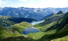
Lepontine Alps
They are located in Switzerland (Valais, Ticino, Uri and Graubünden) and Italy (Piedmont and Lombardy).[2] Following the line marking the division of the waters that flow into the Po from those that feed the Rhone or the Rhine, the main ridge of the Lepontine Alps describes a somewhat irregular curve, convex to the north, from the Simplon Pass to the Splügen Pass.With the single exception of the Monte Leone, overlooking the Simplon Pass, the summits of this portion of the chain are much inferior in height to those of the neighbouring chains; but two peaks of the Adula group, culminating at the Rheinwaldhorn, exceed 11,000 feet (3,400 m) in height.[2] The extensive region lying south of the main ridge is occupied by mountain ranges whose summits sometimes rival in height those of the dividing ridge, and which are cut through by deep valleys, three of which converge in the basins of Lake Maggiore and Lake Como, the deepest of all the lakes on the south side of the Alps.This has been known from a remote antiquity because it leads to the St Gotthard Pass, one of the easiest lines of communication between northern and southern Europe.


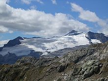
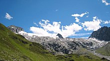
ElevationListingProminent mountains of the AlpsCoordinatesGermanItalianSwitzerlandCantonsRegionsValaisTicinoGraubündenPiedmontLombardyRange coordinatesParent rangePennine AlpsBernese AlpsUri AlpsGlarus AlpsWestern Rhaetian AlpsLugano PrealpsTopo mapswisstopoOrogenyAlpine orogenyFrenchmountain rangeSimplon rail tunnelDomodossolaGotthard railErstfeldGotthard roadAndermattAiroloSan Bernardino road tunnelSt Gotthard PassSplügen PassAdula AlpsTicino AlpsValle LeventinaSimplon PassMonte LeoneRheinwaldhornLake MaggioreLake ComoRhôneList of mountains in SwitzerlandZervreilaseeBlinnenhornLago RitomPizzo di ClaroGüferhornBasodinoPizzo TambòHelsenhornWasenhornOfenhornScherbadungPiz MedelPizzo RotondoHohsandhornPiz TerriPizzo di CassimoiKastelhornPiz AulPizzo PescioraWitenwasserenstockCampo TenciaLeckihornBruschghornLorenzhornAlperschällihornChilchalphornSaashörnerPizzo di BoccareccioPiz CorbetPiz BlasMonte GioveCime di Val LogaPizzo CentralePizzas d'AnarosaPiz BeverinTeurihornPiz de MuciaPiz PombiPizzo LucendroPiz DenterPiz TomulPiz CavelPiz CaschlegliaBarenhornPoncione di ManióPizzo FiorèraPizzo FornoPiz MuraunZervreilahornValserhornPiz SerenastgaCima della BiancaPunta della RossaPoncione di ValleggiaPunta ValgrandeMonte CistellaPiz CanalI RodondPiz MalerFil de DragivaPiz RieinFibbiaMonte ProsaPizzo di CampedellPiz UccelloPizzo del TortoPizzo di RödPizzo SolögnaRasivaCima di PiancabellaPizzo d'OrsaliaPizzo MaloraCima de NomnomPoncione dei LaghettiPiz d'ArbeolaBreithornPizzo PagliaPiz Pazzola