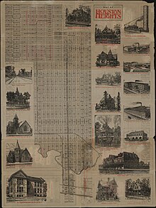
Houston Heights
The company purchased 1,756 acres (7.11 km2) of land and established infrastructure, including streets, alleys, parks, schools, and utilities, worth $500,000.[3] Another appealing factor to potential residents was that the area is 23 feet higher in elevation than Houston, which was experiencing yellow fever outbreaks along with other waterborne illnesses due to excessive flooding and high levels of mosquitos.Some of her research stemmed from a document and photograph collection organized by Jimmie May Hicks, the head librarian at the Heights Public Library from 1931 to 1964.[8] Marilyn Bardsley of Crime Library stated that the Houston Heights became "decrepit" and "tired" after World War II.For most of the period of his crime spree, Corll lived in or close to Houston Heights as his two teenage accomplices resided there.Since the 1990s, and similar to other parts of Houston inside the 610 Loop, the Heights has experienced gentrification, a process ongoing to this day, as young highly paid professionals (many of whom work in Downtown Houston) have flocked to the area, purchasing and renovating some of the historic homes (and demolishing some of them to build newer, upscale housing).Upscale boutiques and restaurants have opened in the area, giving parts of the streetscape an appearance not too much unlike Bellaire, Lower Westheimer or Upper Kirby, [citation needed] but large parts, such as the entirety of Heights Boulevard retain some of the original identity thanks to the older houses and large trees.A National Geographic article says "stroll the area's broad, tree-canopied esplanades and side streets dotted with homes dating from the early 1900s and you may think you've landed in a small town."[7] In 2011 John Nova Lomax said that the Heights, which he describes as "Houston's own mini-Austin," had many "low-key" restaurants and beer gardens.[18][19][20] According to a study of the University of Houston Institute of Regional Forecasting and Crawford Realty Advisors, from 2002 to 2003 prices of single family houses appreciated by 8.7 percent.[22] In 1976 James Conaway of the Texas Monthly described the Heights as a "seedy, lower-middle-class enclave with horizons limited to once-fashionable homes divided into low-rent apartments, and guarded by pickups on concrete blocks.[32] As of 2011 most of the Heights is a part of Houston City Council District C,[17][33] while a portion is in District H.[34] Because of the inclusion of the Heights, Montrose, and Rice University areas, it has the nickname "Hipstrict" for what Chris Moran of the Houston Chronicle refers to as its "progressive, urban ethic.Operations and post office boxes are moving to the TW House Station located at 1300 West 19th Street.[45] A National Geographic Traveler article stated that the Houston Heights "maintains a quirky sense of individuality" and "flourishes as a destination for foodies, architecture buffs, and creative types.[9] As of 2016[update] Sharon Lauder publishes a monthly newspaper that was created in 1986, The Heights Tribune; businesses receive copies of this publication.[52] HISD's Central Region offices were located in the Houston Heights in the former Holden Elementary building.[53] Elementary schools that serve portions of the Houston Heights include Harvard,[54] Helms Community Learning Center,[55] Field,[56] Love,[57] and Sinclair.During the same year, Twenty-Third Street Elementary School in the Houston Heights received fire damage, so it closed.[84] Prior to Houston ISD's 2005 reorganization,[85] the North Central District was headquartered in the Cooley Facility.[86] It served as the headquarters of HISD's alternative certification program until 2010, when the location was sold to a home builder.Previously Crockett Elementary School in the Sixth Ward served a small section of the Houston Heights north of Interstate 10.Its demographics and level of financial support strongly contrast with other Heights area elementary schools.Love Park has an outdoor basketball pavilion, a 0.2-mile (0.32 km) hike and bicycle trail, a playground, a lighted sports field, and a swimming pool.[7] The MKT/SP Heights Trail runs along the south edge of the neighborhood approximately 4.6 miles, with mixed use for pedestrians and bikers.[99] The Heights is the locale of Houston's White Linen Night, held annually in late July or early August.[102] The Houston Heights Association was organized in 1973 by residents and business owners to work together toward maintaining the quality of life and preserving the historic character of the community.[103] The association owns several properties, one of which is Marmion Park, which is at the original location of the Cooley mansion, one of the first houses built in Houston Heights.Today the club volunteers in efforts to improve the Heights neighborhood, in particular mentoring children and assisting the elderly.

NeighborhoodCountryCountyHarrisTime zoneCentral (CST)ZIP codeArea code(s)HoustonNorhillWoodland HeightsNebraskaplanned communitiesstreetcar suburbyellow fever outbreaksmosquitosU.S. Census of 1900World War IIHeights Public LibraryDean Corllabout 100 houses and other properties in the Heights have been listedNational Register of Historic Places610 LoopgentrificationBellaireLower WestheimerUpper KirbyHouston Heights Fire StationCNN MoneyDowntown HoustonNational GeographicAustinInterstate 10Interstate 610University of HoustonPensacola News JournalNorth HillTexas Monthlyalcoholic beveragesHouston Fire DepartmentNorthsideHouston Police DepartmentHouston City CouncilMontroseRice UniversityHouston ChronicleUnited States Postal ServiceHarris Health SystemBen Taub General HospitalTexas Medical CenterMetropolitan Transit Authority of Harris County, TexasNational Geographic TravelerRushmoreWes AndersonHoustoniaThe LeaderFiesta MartHouston Community CollegeGulf Coast Bible CollegeOklahoma City, OklahomaHeights High SchoolHouston Independent School DistrictHarvardUniversity of St. ThomasShell Oil Co.Ministry of EducationWaltrip High SchoolArabic Language Immersion Schoolstate charter schoolsHouston Heights High SchoolTrinity Classical SchoolBritish International School of HoustonGreater KatyEnergy Institute High SchoolSixth WardHarvard Elementary SchoolArabic Immersion Magnet SchoolHeights Neighborhood LibraryHouston Public LibraryItalian RenaissanceAll Saints Catholic ChurchRoman Catholic Archdiocese of Galveston-HoustonHeights Christian ChurchSunset Heights Extension No. 2Köppen Climate Classificationhumid subtropical climateDan RatherMartha WongT.C. JesterJohn Ross PalmerNational Register of Historic Places listings in Houston Heights, Houston, TexasHistory of HoustonDistricts and communities of HoustonGeographic areas of HoustonHouston PressWayback MachineEmmis CommunicationsGoogle BooksGreater Northside Management DistrictHarris County Hospital DistrictArcadia PublishingKPRC-TVGoogle MapUniversity of California PressIncarnate Word AcademyOak ForestSpring BranchNeartownDowntownHouston HeightsHouston ISDHarvard ESHeights HS (former Reagan HS)Houston Heights Charter HSIsbell HouseMorton Brothers GroceryOriental Textile MillWebber HouseSchauer Filling StationHouston Heights Woman's ClubOther NRHP listingsHouston Mass Murders by Dean CorllNicknameArchitectureClimateCulture

