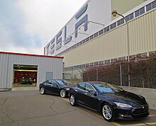
Fremont, California
It is the closest East Bay city to the high-tech Silicon Valley network of businesses, and has a strong tech industry presence.[13][14] The city's origins lie in the community that arose around Mission San José, founded in 1797 by the Spanish under Padre Fermín Lasuén.Fremont was incorporated on January 23, 1956, when the former towns of Mission San José, Centerville, Niles, Irvington, and Warm Springs unified into one city.The recorded history of the Fremont area began on June 6, 1797, when Mission San José was founded by the Spaniard Father Fermín de Lasuén.They were primarily hunter-gatherers; men hunted and trapped waterfowl, rabbits, deer, elk, and bears, whilst women gathered nuts, berries, and root vegetables.The Spaniards brought cattle, pigs and sheep and encouraged the Ohlone to give up hunting and gathering to try farming and ranching instead.[16] Living in the missions meant Ohlone people were forced into converting to Christianity and told to forget the superstitious beliefs that connected them to nature.His family was influential in the Fremont area in the late colonial era and owned and built a flour mill at the mouth of Niles Canyon.[17] In 1846 the town's namesake John C. Frémont led a military expedition to map a trail through Mission Pass for reaching the Pacific coast and to take possession of California from Mexico for the United States.Until the 1906 San Francisco earthquake caused its destruction, the Fremont area's Palmdale Winery was the largest in California.[18] From 1912 to 1915, the Niles section of the Fremont area was the earliest home of California's motion picture industry[19] (see Essanay Studios).Solyndra, a solar panel manufacturer, was promoted in 2010 by President Barack Obama as a model for government investment in green technology[24] after his administration approved a $535 million Department of Energy loan guarantee and the company built a $733 million state-of-the-art robotic facility, but in 2011 the company filed for Chapter 11 bankruptcy and laid off 1,000 workers.[29] After President Roosevelt issued Executive Order 9066, which authorized military commanders to exclude "any or all persons" from certain areas in the name of national defense, the Western Defense Command began ordering Japanese Americans living on the West Coast to present themselves for "evacuation" from the newly created military zones.For city planning purposes, Centerville was enlarged to encompass most of the north central residential section of Fremont, from Mowry Ave to Decoto Rd, from I-880 to the BART line.and the Cabrillo Park subdivision bound by Thornton Ave, Fremont Blvd, Decoto Road and the I-880 freeway.Old Town Niles features its own library, post office, and silent movie theater as well as a large number of antique and craft stores.Realizing the financial opportunity of the area, the former slaves constructed the first building at the cross roads, a tavern with an inn.The Irvingtonian period of North American mammals is named for this district due to the fossil sequence excavated here.Owing to an influx of professionals and other affluent families seeking access to the top-performing local public schools, Mission San Jose's median home value reached $831,000 in 2006, earning the community a rank of 237 on Forbes magazine's list of the 500 most affluent communities in the United States.Fremont has a warm-summer Mediterranean climate (Köppen: Csb) typical of the San Francisco Bay Area.Like nearby San Jose, precipitation is fairly low (about 17 inches or 430 mm per year) because the city lies in the rain shadow of the Santa Cruz Mountains to the west.[68] Judith Miller of City Journal wrote that unlike many ethnic groups, the Afghans in Fremont have few political representatives at various levels and an insular focus.Companies headquartered in Fremont include Antec Inc, Corsair Gaming, Electronics for Imaging, Ikanos Communications, Lam Research, Seagate Technology, Fremont Bank, Nielsen Norman Group, Oplink Communications, SYNNEX, S3 Graphics, Tailored Brands and DCKAP.The city operates the Olive Hyde Art Gallery, adjacent to Mission San Jose, which has featured Bay Area artists such as Wendy Yoshimura, the California Society of Printmakers and the Etsy collective.Budget problems have in some past years involved cuts in services, reductions in city staffing and wage concessions by labor unions.In 2015, a grand jury found that the city government did not comply with state law on public records,[76] by deleting most emails after 30 days instead of the required two years.The council chose the new district boundaries in June 2017, a controversial vote that drew accusations of gerrymandering to favor two of the incumbents.[81][80] The districting was forced by the threat of a legal action from a group claiming that Latino minorities comprising 14 percent of the population had not been adequately represented.Though they do not intersect, they are connected in the Warm Springs district via a very busy one-mile segment of Mission Boulevard which is SR 262.Caltrain is undertaking environmental and engineering review for a planned Dumbarton Rail Corridor between the Peninsula and Alameda County.


Mission San JoséMission PeakLake ElizabethWashington High SchoolCountryUnited StatesCaliforniaCountyAlamedaIncorporatedNamed forJohn C. FrémontCouncil–managerCity councilVice MayorCity managerState senatorAisha WahabAssembly membersLiz OrtegaAsh KalraUnited States RepresentativesEric SwalwellRo KhannaTime zoneUTC−8PacificUTC−7ZIP codesArea code510, 341Alameda County, CaliforniaEast BayBay Areamost populous city in the Bay AreaSan JoseSan FranciscoOaklandSilicon ValleyFermín LasuénConquest of CaliforniaMilitary Governor of CaliforniaU.S. SenatorFermín de LasuénVallejo MillJosé de Jesús VallejoOhlonegrizzly bearNiles CanyonJedediah SmithsecularizationMariano VallejoRancho Arroyo de la AlamedaMexican land grantflour millMission PassDominicanCalifornia Gold RushHayward earthquakeHayward Fault1906 San Francisco earthquakeEssanay StudiosCharlie ChaplinThe Trampfirst Mac computersemiconductortelecommunicationsCirrus LogicLam ResearchSan Francisco Bay AreaTesla FactoryGeneral MotorsToyotaTesla MotorsSolyndraBarack Obamagreen technologyDepartment of EnergyChapter 11Seagate TechnologyNewarkNewpark MallUnion CityTri-ValleyPleasantonDublinLivermoreWashington TownshipCenterville Pioneer CemeteryRooseveltExecutive Order 9066Western Defense CommandHousing developmentsGlenmoor GardensQuarry Lakes Regional Recreation AreaAmerican High SchoolMission BoulevardState Route 238Union Pacific RailroadVallejo MillsCentral Pacific RailroadFirst transcontinental railroadAddison NilesCalifornia Supreme CourtBroncho Billy AndersonNiles Essanay Silent Film MuseumNiles Canyon RailwayAlameda CreekWestern Pacific RailroadIrvine, CaliforniaWashington CollegeAlameda CountyAuto MallIrvington High SchoolRobertson High SchoolJohn F. Kennedy High SchoolIrvingtonianMission RidgeMount AllisonOhlone CollegeAsian Americans2000 censusMission San Jose High SchoolZIP codeprofessionalsForbes