Guiana Shield
The rocks of the Guiana Shield consist of metasediments and metavolcanics (greenstones) overlain by sub-horizontal layers of sandstones, quartzites, shales and conglomerates intruded by sills of younger mafic intrusives such as gabbros.South of that fault are Early Proterozoic rocks consisting of the metavolcanic Pastora Supergroup and the granitic plutonic Supamo Complex.[4][5] There are three upland areas of the Guiana Shield: The north-central part of the Guiana Highlands is dominated by high flat-topped peaks called tepuis, of the Roraima supergroup and Quasi-Roraima formation, and the rounded granite peaks of the Parguaza and Imataca complexes to the north and southwestern edges of the area.The region houses over 3000 vertebrate species: 1168 fresh water fish, 269 amphibians (54% endemics), 295 reptiles (29%), 1004 birds (7.7%), and 282 mammals (11%).[14] According to recent researches, although ecosystems of the Guayana Highlands remain vibrant, emerging issues (including "a well-known invasive plant elsewhere" Poa annua and "one of the most aggressive weeds" Polypogon elongatus) and infectious faecal bacteria Helicobacter pylori have been documented.

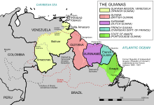


South AmericaCerros de MavecureGuainía departmentCanaima National ParkFrenchPortugueseSpanishcratonsSouth American PlatePrecambrianformationshieldtepuisAngel FallsKaieteur FallsCuquenan FallsGuyanaSurinameFrench GuianaVenezuelaColombiaBrazilgreenstonessandstonesquartzitesshalesconglomeratesgabbrosArcheanquartzfeldspargneissProterozoicmetavolcanicSupergroupgraniticplutonicash flowclastic sedimentaryOrinocoRoraimaWilhelmina MountainsTumuc-Humac MountainsAmapáAtlanticChiribiquete PlateauplateauNeogenePico da NeblinaNeblina massifHeliamphora chimantensisendemicChimantá MassifVenezuelanbiodiversityvertebratevascular plantsAmazonian rain forestKanukuWorld Heritage SiteCentral Suriname Nature ReserveGuiana Amazonian ParkTumucumaque National ParkCanaimaParima-TapirapecoSerranía de la NeblinaRamsar ConventioninvasivePoa annuaPolypogon elongatusHelicobacter pyloriGran SabanaCanadian ShieldCaribbean South AmericaMount RoraimaGreat American InterchangeGeography of South AmericaGuianasBrazilian Institute of Geography and StatisticsDiversity and DistributionsBibcodeTectonic platesAntarcticCaribbeanMalpeloNorth AndesScotiaSouth AmericanshieldsAmazonian CratonArequipa-Antofalla CratonAtlantic ShieldCentral Brazilian ShieldParanapanema BlockRío Apa CratonRío de la Plata CratonSão Francisco CratonUruguayan ShieldsubductionAntarctic plateCarnegie RidgeChile RiseJuan Fernández RidgeMalpelo RidgeNazca plateNazca RidgeFaultsshear zonesAtacamaBoconóBucaramanga-Santa MartaCochabambaCordillera BlancaCórdobaDolores-GuayaquilDomeykoEastern FrontalGastreHuinculLiquiñe-OfquiMagallanes-FagnanoMorónOca-AncónPernambucoEl PilarRomeral