Guayana Region, Venezuela
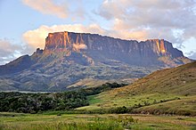
The region comprises, according to Venezuelan law, four of the federal States of Venezuela: Some of the biggest towns and cities include: The relief of the Guayana Region is very varied, including plains and savannahs, with heights ranging from 100 to 500 m. The Gran Sabana is a plain with an average altitude of 1,000 m. and is home to the tepuis, extraordinary geological formations, including the 2.810 m Roraima, the Auyantepui, with the highest waterfall in the world; the Salto Ángel, with its almost one thousand meters of vertical drop; and several sierras or mountain ranges which reach considerable peaks and whose culminating point is the Marahuaca hill with its 3,840 m. Everything about the relief can be seen in greater detail in each of the states that make up Guyana and will be described separately in each of them.The gold mine at El Callao (Venezuela), started in 1871, was for a time one of the richest in the world, and the goldfields as a whole saw over a million ounces exported between 1860 and 1883.In 1926, a Venezuelan mining inspector found one of the richest iron ore deposits near the Orinoco delta, south of the city of San Felix on a mountain named El Florero.The region also has vast forest reserves, and extensive rivers, as Orinoco and Caroni, that provide much of the electricity consumed in the country, as well as great tourism potential with places like Canaima National Park which includes the highest waterfall in the world (Angel Falls) and is rich in heavy oil that is concentrated in the northern area of Bolivar State.In the region of Guayana, due to its great hydroelectric potential, it has mining wealth: that is to say, abundance of iron ore and bauxite, one of the main heavy industries of Latin America has been installed.


The Guianasadministrative regionVenezuelaRafael CalderaBolívar StateDelta Amacuro StateAmazonas StateGuyanaBritish GuianaBrazilGuiana ShieldGuayana HighlandstepuisPuerto OrdazCiudad BolívarStates of VenezuelaGuayana Esequiba StateCiudad GuayanaSalto ÁngelLa Gran SabanaAuyantepuiEl Parque Nacional De CanaimaCanaima National ParkSiderúrgica del OrinocoCorporación Venezolana de GuayanaFlora of the Venezuelan Guayana. Volume 1. Introduction.Administrative divisions of VenezuelaCapital DistrictCaracasStatesAmazonasAnzoáteguiAraguaBarinasBolívarCaraboboCojedesDelta AmacuroFalcónGuáricoLa GuairaMéridaMirandaMonagasNueva EspartaPortuguesaTáchiraTrujilloYaracuyFederal DependenciesLos Monjes ArchipelagoLas Aves ArchipelagoAves IslandLos Hermanos ArchipelagoLos Frailes ArchipelagoLos Roques ArchipelagoLa Sola IslandLa Tortuga IslandLa Orchila IslandLa Blanquilla IslandLos Testigos IslandsPatos IslandRegionsAndeanCapitalCentralCentral-WesternEasternInsularLlanosZulianDisputed stateGuayana EsequibaFederal TerritoriesAmazonas Federal TerritoryDelta Amacuro Federal TerritoryAmapáFrench GuianaEsequibaSurinameTigri AreaBerbiceDemeraraEssequiboCounaniPre-1667PomeroonSurinamTrinidad-GuayanaSurinam (English colony)