Great Basin

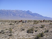
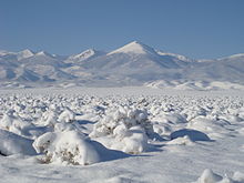
The Great Basin (Spanish: Gran Cuenca) is the largest area of contiguous endorheic watersheds, those with no outlets to the ocean, in North America.The term "Great Basin" is applied to hydrographic,[3][4]: 11  biological,[3] floristic,[4]: 21  physiographic,[4]: 14  topographic,[3] and ethnographic geographic areas.[4]: 34  The name was originally coined by John C. Frémont, who, based on information gleaned from Joseph R. Walker as well as his own travels, recognized the hydrographic nature of the landform as "having no connection to the ocean".As observed by Fremont, creeks, streams, or rivers find no outlet to either the Gulf of Mexico or the Pacific Ocean.The region is bounded by the Wasatch Mountains to the east, the Sierra Nevada and Cascade Ranges to the west, and the Snake River Basin to the north.As it dried during the Holocene epoch, some species retreated to the higher isolated mountains and have high genetic diversity.Great Basin wildlife includes pronghorn, mule deer, mountain lion, and lagomorphs such as black-tailed jackrabbit and desert cottontail and the coyotes that prey on them.Exotic species, including chukar, grey partridge, and Himalayan snowcock, have been successfully introduced to the Great Basin, although the latter has only thrived in the Ruby Mountains.[20] The basin and range topography is the result of extension and thinning of the lithosphere, which is composed of crust and upper mantle.To the south are Cedar City, Tonopah, and Bishop and the very southern area of the basin has the communities of Pahrump, Palmdale, Victorville, and Palm Springs.[29] Archaeological evidence of habitation sites along the shore of Lake Lahontan date from the end of the ice age when its shoreline was approximately 500 feet (150 m) higher along the sides of the surrounding mountains.They hunted animals like mule deer and antelope and gathered onions, wild rye, and pinyon pine nuts.Unlike the Paleo-Indians, who moved around to follow bison herds, the Fremont built small villages and grew crops like corn and squash.[citation needed] European exploration of the Great Basin occurred during the 18th century Spanish colonization of the Americas.[31] Peter Skene Ogden of the British Hudson's Bay Company explored the Great Salt Lake and Humboldt River regions in the late 1820s, following the eastern side of the Sierra Nevada to the Gulf of California.[33] Around 1902, the San Pedro, Los Angeles and Salt Lake Railroad was constructed in the lower basin and Mojave Desert for California-Nevada rail service to Las Vegas, Nevada.Due to the region's altitude and aridity, most areas in the Great Basin experience a substantial diurnal temperature variation.
The hydrographic Great Basin (magenta outline), distinguished from the Great Basin Desert (black), and the Basin and Range Geological Province (teal). [ 3 ]
The Tule Valley watershed and the House Range ( Notch Peak ) are part of the Great Basin's Great Salt Lake hydrologic unit
Ecoregions as currently delineated by the Environmental Protection Agency [ 13 ] and World Wildlife Fund [ 14 ]
Great Basin snowstorm in the Snake Valley of Utah and Nevada
Basin and Range topography as seen from the air
Map showing the Great Basin physiographic section (shown as 22a)
Native American tribes that inhabited the Great Basin were divided between the "Great Basin" and, in the Colorado Desert region, the " California " tribal classifications.
Wah Wah Valley , Utah , thunderstorm
Great Divide BasinEndorheic basinMount WhitneySpanishendorheic watershedsNorth AmericaNevadaCaliforniaOregonWyomingBaja Californiabasin and range topographyBadwater BasinDeath Valleycontiguous United StatesphysiographicbiomesecoregionsdesertsGreat Basin DesertBasin and Range Geological ProvincehydrographicbiologicalfloristictopographicethnographicJohn C. FrémontJoseph R. WalkerNational Park ServicepanhandleGreat Basin ProvinceArmen TakhtajanSnake River PlainColorado PlateauUinta BasinArizonaMogollon RimBasin and Range ProvinceNevin FennemanUnited States Geological SurveyPhysiographic division of the United Statesindigenous peoples of the Great Basinclassification of indigenous peoples of the Americascultural regionList of Great Basin watershedsList of rivers of the Great BasinTule Valley watershedHouse RangeNotch Peakhydrologic unitGulf of MexicoPacific OceanWasatch MountainsSierra NevadaCascade Snake River BasinBaja California, MexicoGreat Salt LakePyramid LakeHumboldt SinkSalton SinkGreat Basin DivideLaguna SaladaBear RiverHumboldt Rivergroundwateraquifersgeographic sinksLake Tahoealpine lakeLahontanMojave DesertSnake ValleyMojaveColoradoSonoran DesertGreat BasinOregon HighJoshua treecreosote bushUtah junipersingle-leaf pinyonmountain mahoganypinyon-juniper woodlandlimber pinePinus longaevariparianPopulus fremontiiPopulus tremuloidesWorld Wildlife FundGreat Basin montane forestsLast Glacial PeriodHolocenehigher isolated mountainsEnvironmental Protection AgencyNorthern Basin and Range ecoregionCentral Basin and Range ecoregionMojave Basin and Range ecoregionpronghornmule deermountain lionlagomorphsblack-tailed jackrabbitdesert cottontailcoyotesPackratskangaroo ratsbighorn sheeplizardsGreat Basin fence lizardlongnose leopard lizardhorned lizardRattlesnakesgopher snakesInyo Mountains salamanderphalaropescurlewsAmerican white pelicansGolden eaglesMourning dovewestern meadowlarkblack-billed magpiecommon ravenendangered speciesCui-uisucker fishLahontan cutthroat troutinvertebratestarantulasAphonopelmaMormon cricketschukargrey partridgeHimalayan snowcockRuby MountainsCheatgrassinvasive specieshorsesmustangsburrosopen rangecattlelithosphereupper mantlelistric normal faultinggrabenlacustrine plainsPleistoceneyears agoLake BonnevilleBonneville FloodRed Rock PassUtah LakeSevier LakeRush LakeLittle Salt LakeLake LahontanLake ManlyLake Mojavephysiographic sectionColorado RiverReno-Sparks metropolitan areaWasatch FrontWendoverWest WendoverWinnemuccaSusanvilleEvanstonCedar CityTonopahBishopPahrumpPalmdaleVictorvillePalm SpringsInterstate HighwaysInterstate 80U.S. Route 6US 50US 93US 95US 395Delta, UtahFallon, NevadaNevada State Route 375Union Pacific RailroadOverland Route (Union Pacific Railroad)Feather River RouteCentral CorridorLos Angeles and Salt Lake Railroadtribal classifications.Paleo-Indian habitationGreat Basin tribesArchaeologicalpinyon pineFremontNorthern PaiuteWestern Shoshone Claims Distribution Act of 2004for the acquisitionSpanish colonization of the AmericasJedediah Strong SmithPeter Skene OgdenHudson's Bay CompanyBenjamin Bonneville1832 expedition42nd parallelAdams–Onís TreatyOregon TreatyMexican CessionMormonState of DeseretCalifornia Gold RushCalifornia TrailCarson PassOregon TerritoryUtah TerritoryFirst transcontinental railroadPromontory SummitSan Pedro, Los Angeles and Salt Lake RailroadWah Wah Valleyrain shadowalpine climatediurnal temperature variationGreat Basin National ParkWarren G. HardingDeath Valley National ParkJoshua Tree National ParkMinerva HoytDesert Protection ActValley of Fire State ParkNational Natural LandmarkGolden Spike National Historic SiteCongressJuan Bautista de Anza National Historic TrailPony ExpressNational Historic TrailsMojave National PreserveUS CongressBlack Rock Desert–High Rock Canyon Emigrant Trails National Conservation AreaOld Spanish National Historic TrailGreat Basin National Heritage AreaAmargosa RiverWild and Scenic RiverBureau of Land ManagementBasin and Range National MonumentAntiquities ActBarack ObamaGardenBonneville Salt FlatsGreat Basin Landscape Conservation CooperativeHastings CutoffHidden CaveNevada BasinSalton SeaGeographic Names Information SystemUnited States Department of the InteriorThorne, Robert F.Internet ArchiveTruckee RiverWorld Digital LibraryNew International EncyclopediaregionssubregionsWorldsArab WorldDown UnderNew WorldOld WorldThree/Four WorldsFirst WorldSecond WorldThird WorldFourth WorldHemispheresEastern HemisphereLand HemisphereNorthern HemisphereSouthern HemisphereWater HemisphereWestern HemisphereLandmassesAfrica-EurasiaEurasiaAmericaAntarcticaAustraliaZealandiasubmergedTectonic platesContinentsAfricaMediterraneanSaharanNorthernMaghrebMashriqMiddle EastMiddle East and North AfricaSub-SaharanCentralGreat LakesSouthernWesternEast AntarcticaAntarctic PlateauTransantarctic MountainsWest AntarcticaAntarctic PeninsulaAsia–PacificAral SeaAralkum DesertCaspian SeaEasternInner AsiaGreater Central AsiaNortheasternFar EastPacific AsiaRussian Far EastSiberiaSoutheasternMainlandMaritimeHimalayan statesIndian subcontinentArabian PeninsulaCaucasusSouth CaucasusGreater IranIranian plateauLevantDead SeaLevantine SeaNear EastEuropeBalkansNorth CaucasusSouthern RussiaEuropean RussiaBalticBritish IslesNordicNorthwesternScandinaviaScandinavian PeninsulaItalian PeninsulaSouth-easternBalkan PeninsulaSouth-westernIberian PeninsulaAtlanticLow CountriesCelticGermanicRomanceSlavicAridoamericaCaribbeanMesoamericaMiddleAppalachiaBible BeltEast CoastMid-AtlanticMidwestMountain statesNew EnglandNortheastern United StatesPacific NorthwestSouthern United StatesSouthwestWest CoastWest South Central United StatesWestern United StatesAtlantic CanadaCanadian PrairiesCentral CanadaEastern CanadaNorthern CanadaWestern CanadaNorthern MexicoWest IndiesFrenchHispanicPortugueseLatin America and the CaribbeanOceaniaAustralasiaMainland AustraliaNew GuineaTasmaniaMelanesiaIsland MelanesiaMicronesiaNear OceaniaPolynesiaRemote OceaniaSouth AmericaAmazon PlainAmazon BasinAmazon RainforestAndean StatesBrazilian HighlandsCaribbean South AmericaThe GuianasSouthern ConePatagoniaIslandscontinentCentral Americaby areaby populationNew ZealandArctic OceanAtlantic OceanBaltic SeaBlack SeaCaribbean SeaIrish SeaMediterranean SeaAdriatic SeaAegean SeaIonian SeaIndian OceanPersian GulfEast China SeaSouth China SeaSouthern OceanOceansAntarctic/Southern OceanAntarctic ConvergenceGreat Barrier ReefMariana TrenchRing of FirewaterbodiesRiversAtlantic RimIndo-MediterraneanIndian Ocean RimMediterranean RimPacific RimAntarcticArcticGlobal EastGlobal NorthGlobal NortheastGlobal NorthwestGlobal SouthGlobal SoutheastGlobal SouthwestGlobal WestWeber RiverJordan RiverGreat Salt Lake DesertEscalante DesertSevier RiverBlack Rock DesertCarson RiverWalker RiverKern RiverTule RiverTulare LakeMono LakeOwens LakeMojave RiverGoose LakeLost RiverSan Jacinto River