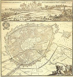
Fortifications of Brussels
In the 19th century, the second walls were torn down and replaced with the Small Ring, a series of boulevards bounding the historical city centre.Louis invaded Brabant and quickly seized Brussels, planting the Flemish lion flag in the middle of the Grand-Place.This enabled Joanna and Wenceslaus to make their Joyous Entry into Brussels, granting a charter of liberties that would be seen as the equivalent of the Magna Carta for the Low Countries.The design was fairly typical of medieval defences before the introduction of gunpowder, and was surrounded by a moat in the lower parts of the city.The Fort of Monterey [nl; fr] was the most important defensive work, its name coming from the Spanish count responsible for modernising the defences.The fort was built between 1672 and 1675, by the military engineers Merex and Blom, on the heights of Obbrussel (Old Dutch: Obbrusselsche, for "Upper Brussels", now Saint-Gilles), south of the Halle Gate.[5] As with the rest of the city's fortifications, the fort was ineffective, and was not able to prevent the French bombardment of Brussels in 1695, from the heights of Scheut, in Anderlecht, as part of the War of the Grand Alliance.With the return of stability, in 1818, authorities organised a contest for plans to demolish the ramparts and replace them with boulevards suited to the exigencies of contemporary life in the city.A barrier with a ditch running its length was still installed, however, and toll pavilions built at the entrances, to allow continued taxation of commercial goods entering the city.From 1868 to 1871, as the city was being modernised, the architect Henri Beyaert, with little regard for historical accuracy, transformed the austere medieval tower into something of a neo-Gothic castle, which fit better with the contemporary romantic perception of the Middle Ages.In the 1950s, with pressure from the automobile, new plans to improve traffic flow were implemented, partly due to the 1958 Brussels World's Fair (Expo 58).


FrenchBrusselsBelgiumCity wallsmedievalSmall RingHalle GateHenry IBrabantSaint-Géry/Sint-Goriks IslandGrand-Place/Grote MarktCathedral of St. Michael and St. Gudulacollegiate churchducal palace of Coudenbergpillarsarrow slitsarcadecrenellatedparapetEverard t'SerclaesDuke John III of BrabantJoannaWenceslaus I of LuxembourgLouis IIFlandersMargaretFlemish lion flagJoyous EntryMagna CartaLow CountriesEverard 't SerclaesschepenhamletsWenceslas HollarPanoramic view of BrusselsJan Baptist Bonnecroy1695 bombardmentLaekenAnderlechtLeuvenSchaerbeekPort of BrusselsWillebroek Canalsiege weaponsartillerybastionsravelinsSpanishmilitary engineersSaint-Gillesbombardment of BrusselsScheutWar of the Grand Allianceseized the cityWar of the Austrian SuccessionJoseph IILaeken GateRepublican FranceannexedNapoleonordinancemedianFirst French EmpireAnderlecht GateBrussels–Charleroi CanalBelgium gained its independenceHenri Beyaertneo-GothicromanticMiddle AgesNamur GateAvenue Louise/LouizalaanBois de la Cambre/Ter KamerenbosPentagonautomobileExpo 58Brussels Metroring roadBlack TowerSt. Catherine's ChurchFlanders GateSchaerbeek GateNeoclassical architecture in BelgiumHistory of BrusselsBelgium in the long nineteenth centuryCity of BrusselsFlemish Community CommissionRaymond van UytvenWim BlockmansRevue belge de Philologie et d'HistoireBrussels-Capital RegionBrussels metropolitan areaTimelineMassacre (1370)1656 treaty1746 siegeDuchess of Richmond's ballCovering of the SenneFrancisationExpo 1897Expo 1910Expo 1935Expo 1958L'Innovation department store fireHeysel Stadium disaster2016 bombingsreactionsGovernmentMinister-PresidentParliamentGovernorDrapery Court of BrusselsGuilds of BrusselsS TrainBrussels AirportCharleroi AirportNorth–South connectionBrussels RingSymbolsIris FestivalBrussels and the European UnionScience and technologyNotable personsMuseumsRailway stationsMetro stations