Covering of the Senne
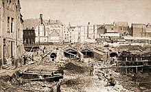
Actual purification of the waste water from the Brussels-Capital Region was not completed until March 2007, when two treatment stations were built, thus finally cleansing the Senne after centuries of problems.The Royal Quarter in the historic upper town, inhabited mainly by the nobility and the richer members of the bourgeoisie, was upscale and modern.[15][16] Early in the second half of the 19th century, Brussels saw numerous dry periods, floods and a cholera epidemic, caused as much by the river itself as by the poverty and the lack of hygiene and potable water in the lower city.[18] The first studies and propositions to clean up the river date back to 1859,[12] and between 1861 and 1864, the Brussels authorities assigned successive commissions of engineers to examine possible solutions.Several of them proposed diverting large amounts of cleaner water from other rivers upstream to dilute the Senne, while greatly improving the drainage system in the city.One branch was to head towards Brussels-North railway station and the present-day Place Charles Rogier/Karel Rogierplein, the other towards the Antwerp Gate, thus forming a long, narrow "Y" shape.[25] The elimination of the numerous alleys and dead-ends in the lower town in favour of a large, straight, wide, open-air boulevard, linking the two rapidly growing train stations, seemed both a necessity and an opportunity to beautify the city and improve both traffic circulation and hygiene.[28][29] The city expropriated large swathes of the lower town, counting on reselling the land for a profit, which, after the project was complete, would be on a grandiose modern boulevard in an upper-class neighbourhood.This opposition came first from engineers who felt that the covering was incompatible with Brussels' geology, would accumulate potentially dangerous gases and would not be able to handle enough water to prevent floods.[36] Excluding the important sewers built upriver and downriver in the adjacent suburbs, the covered section itself was 2.2 kilometres (1.4 mi) in length.[38] Constructed from bricks, the covering consisted of two parallel 6-metre-wide (20 ft) tunnels, and a set of two lateral drainage pipes, each taking in waste water from its respective side of the street.[27] In order to accomplish this revitalisation and attract investment, public buildings were constructed as part of Léon Suys' massive programme of beautification of the city centre,[44][45][46] including the Brussels Stock Exchange (1868–1873).Great freedom was given to the architects; no unity of style was sought nor imposed (other than a minimum height of 15 metres (49 ft) to avoid speculation) and the monumental composition adopted a de facto eclectic approach throughout the immense perspective of the boulevards.[53][54][55] The first prize of 20,000 Belgian francs for the 1872–1876 competition was awarded to the architect Henri Beyaert who designed the Maison des Chats or Hier is't in den kater en de kat (loosely, "House of Cats") on the Boulevard du Nord.[citation needed] The former Temple of the Augustinians, built at the beginning of the 17th century in the Brabantine Baroque style after designs by Jacob Franquart, was the only remaining part of a convent destroyed in 1796 by French revolutionaries.The work to cover the river, which nearly surrounded the church, preserved the building's integrity at great trouble and expense, but it was finally demolished in 1893, its style no longer popular with the people and its presence unsuitable for the area.These moves were made after the success of the water treatment in earlier decades, and a desire to include more green space in the city, as well as to build the river's ecological resilience, which had been essentially dead.


FrenchBrusselsmajor boulevardshistory of BrusselsSenne/Zennewaterwayhealth hazardworking classCity of Brussels' mayorJules AnspachLéon Suyscentral boulevardsexpropriationembezzlementNorth–South AxispremetroBrussels-Capital RegionmedievalRoyal QuarternobilitybourgeoisiePentagonAnderlechtsecond city wallsBrussels-South railway stationNinove GateSaint-Géry IslandsluiceBrussels–Charleroi Canalnavigable waterwayBrussels–Scheldt Maritime Canalsewagedetrituscholerahygienepotable waterProvince of BrabantCity of BrusselsWastewater treatmentdrainageNorth–South connectionKing Leopold IICity of Brussels' then-mayorTemple of the AugustiniansPlace de Brouckère/De BrouckèrepleinBrussels-North railway stationPlace Charles Rogier/Karel RogierpleinAntwerp Gatedeclared its independence in 1830middle classsuburbsLeopold QuarterEuropean QuarterAvenue Louise/Louizalaantax revenueBelgian Parliamentspeculativeupper-classgeologyliberalBritishBelgian francsvaultingsewerssubsidiesBelgian Stateshovelwater tableCentral Boulevards of BrusselsBoulevard Anspach/AnspachlaanBoulevard Maurice Lemonnier/Maurice LemonnierlaanBoulevard Adolphe Max/Adolphe MaxlaanBoulevard Émile Jacqmain/Émile JacqmainlaanRue Neuve/NieuwstraatHenri BeyaertBrussels Stock Exchangemetallic architecturePlace Fontainas/Fontainaspleinsingle family homeseclecticBrabantineBaroqueJacob FranquartFrench revolutionariesfountain-obeliskIxellesfloodingspillwaysmetropolitan areadiversionSmall RingSecond World Warstorm drainsAnspach Fountainpurificationwaste waterpurification stationsForestFlemish GovernmentFlemish RegionScheldtecological resilienceHaussmann's renovation of ParisBelgium in the long nineteenth centuryinflationCity Archives of BrusselsVilvoordeAquirisBrussels metropolitan areaTimelineFortificationsMassacre (1370)1656 treaty1695 bombardment1746 siegeDuchess of Richmond's ballFrancisationExpo 1897Expo 1910Expo 1935Expo 1958L'Innovation department store fireHeysel Stadium disaster2016 bombingsreactionsGovernment