Boise metropolitan area
[3] It is the main component of the wider Boise–Mountain Home–Ontario, ID–OR Combined Statistical Area, which adds Elmore and Payette counties in Idaho and Malheur County, Oregon.Nearly 40 percent of Idaho's total population lives in the area.As of the 2021 estimate, the Boise–Nampa, Idaho Metropolitan Statistical Area (MSA) had a population of 795,268,[4] while the larger Boise City–Mountain Home–Ontario, ID–OR Combined Statistical Area (CSA) had a population of 850,341.As of the 2010 census, there were 616,561 people, 170,291 households, and 120,118 families residing within the MSA.The racial makeup of the MSA was 89.80% White, 0.52% African American, 0.80% Native American, 1.38% Asian, 0.14% Pacific Islander, 5.02% from other races, and 2.35% from two or more races.

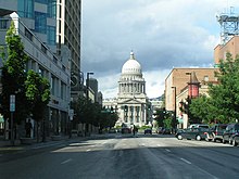


Metropolitan Statistical AreaIdaho State CapitolCity of BoiseCountryUnited StatesOregonMeridianCaldwellMountain HomeOntario, ORPayette74th in the U.S.Time zoneTreasure ValleyCanyonOwyheesouthwestern IdahoElmoreMalheur County, Oregonmetropolitan areaPacific NorthwestSeattlePortlandMalheur2010 censusAfrican AmericanNative AmericanPacific Islanderother racesHispanicLatinoper capita incomeMiddletonGarden CityOntario, OregonEmmettFruitlandHidden SpringsHomedaleMarsingNew PlymouthNyssa, OregonWilderVale, OregonAdrian, OregonCrouchGreenleafHorseshoe BendIdaho CityJordan Valley, OregonPlacervilleAnnex, OregonArock, OregonBasque, OregonBeulah, OregonBowmontBruneauBurns Junction, OregonCairo, OregonCrowley, OregonDanner, OregonGarden ValleyHamilton CornerHarper, OregonHustonIronside, OregonJamieson, OregonJonesboro, OregonJuntura, OregonLowmanMcDermitt, Nevada-OregonMurphyOwyhee, OregonPayette Junction, OregonRiddleRiverside, OregonRome, OregonRoswellSunnyslopeBoise AirportNampa Municipal AirportCaldwell Executive AirportInterstate 84Interstate 184U.S. Route 20U.S. Route 26U.S. Route 30U.S. Route 95State Highway 16State Highway 19State Highway 21State Highway 44State Highway 45State Highway 51State Highway 52State Highway 55State Highway 67State Highway 69State Highway 72State Highway 78State Highway 167Oregon Route 52Oregon Route 78Oregon Route 201Oregon Route 451Oregon Route 452Oregon Route 453Oregon Route 454Boise State UniversityBoise, IdahoNorthwest Nazarene UniversityNampa, IdahoCollege of IdahoCaldwell, IdahoUniversity of IdahoIdaho State UniversityMeridian, IdahoCollege of Western IdahoTreasure Valley Community CollegeNorthwest Lineman CollegeKuna, IdahoStevens-Henager CollegeCarrington CollegeBroadview UniversityUniversity of PhoenixBoise Bible College