Lycoming County, Pennsylvania

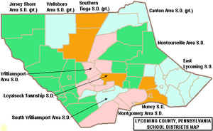
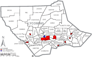
The following counties have been formed from land that was once part of Lycoming County: Armstrong, Bradford, Centre, Clearfield, Clinton, Indiana, Jefferson, McKean, Potter, Sullivan, Tioga, Venango, Warren, Forest, Elk and Cameron.Brule descended the West Branch Susquehanna River and was held captive by a local Indian tribe near what is now Muncy before escaping and returning to Canada.The road followed the Great Shamokin Path from Fort Augusta in what is now Sunbury to Bald Eagle Creek near modern-day Lock Haven.Andrew Gregg was elected to represent Lycoming County in the United States Congress, William Hepburn was voted to the Pennsylvania State Senate and Flavel Roan, Hugh White and Robert Martin served as representatives in the Pennsylvania General Assembly.The county has a humid continental climate which is warm-summer (Dfb) except in lower areas near the river which are hot-summer (Dfa).The river then flows generally east and a little north with some large curves for 15 miles (24 kilometres) to the city of Williamsport, followed by the borough of Montoursville (both on the north bank) as well as the boroughs of Duboistown and South Williamsport (on the south bank).The river flows just north of Bald Eagle Mountain (one of the northernmost ridges of the Ridge-and-valley Appalachians) through much of its course in Lycoming County, but it passes the end of the mountain and turns south just before the borough of Muncy (on the east bank).The major creeks of Lycoming County are all tributaries of the West Branch Susquehanna River.The river receives it at the village of Allenwood in Gregg Township in Union County.The Williamsport Regional Airport has commercial flights to Washington D.C.,[20] and a FBO for private jets and charters.The following cities, boroughs and townships are located in Lycoming County: Census-designated places are geographical areas designated by the U.S. Census Bureau for the purposes of compiling demographic data.
Major fault at the dividing line between the Allegheny Plateau and the true Appalachian Mountains near Williamsport, Pennsylvania
Map of the West Branch Susquehanna River (dark blue) and Major Streams in Lycoming County, Pennsylvania. From west to east (left to right) the watersheds are: Pine Creek (red); Larrys Creek (orange); Lycoming Creek (yellow); Loyalsock Creek (green); Muncy Creek (light blue); and White Deer Hole Creek (purple, south of the river).
Map of Lycoming County, Pennsylvania Public School Districts
Map of Lycoming County, Pennsylvania with Municipal Labels showing Cities and Boroughs (red), Townships (white), and Census-designated places (blue).
CountyPennsylvaniaNamed forLycoming CreekWilliamsportTime zoneUTC−5EasternUTC−4Commonwealth2020 censuscounty seatmetropolitan statistical areaPhiladelphiaPittsburghHistory of Lycoming County, PennsylvaniaNorthumberland CountyArmstrongBradfordCentreClearfieldClintonIndianaJeffersonMcKeanPotterSullivanVenangoWarrenForestCameronThomas Jeffersonpre-Revolutionary border disputeÉtienne BrûlévoyageurNew FranceWest Branch Susquehanna RiverCanadalog cabinsgristmillMuncy CreekGreat Shamokin PathFort AugustaSunburyBald Eagle CreekLock HavenPresbyteriansawmillsheriffcounty commissionersUnited States CongressPennsylvania State SenatePennsylvania General AssemblyLoyalsockrailroadU.S. Census BureauRhode Islandhumid continental climateAppalachian MountainsdissectedAllegheny PlateauboroughJersey ShoreMontoursvilleDuboistownSouth WilliamsportBald Eagle MountainRidge-and-valley AppalachiansMontgomerySusquehanna RiverNorthumberland, PennsylvaniaChesapeake BayPine CreekLarrys CreekLoyalsock CreekWhite Deer Hole Creekleft bankSalladasburgwatershedsSullivan CountyGregg TownshipLimestoneNippenose TownshipsTioga CountyBradford CountyColumbia CountyMontour CountyUnion CountyClinton CountyPotter Countycensuspopulation densityAfrican AmericanNative AmericanPacific Islanderother racesHispanicLatinoGermanAmericanItalianEnglishmarried couplesBlack or African AmericanOther/MixedRepublicanDemocraticThird party(ies)Pennsylvania State PoliceWilliamsport Police DepartmentLycoming County Sheriff's OfficeJamie FlickPennsylvania's 83rd Representative DistrictJoseph D. HammPennsylvania's 84th Representative DistrictGene YawPennsylvania's 23rd Senatorial DistrictDan MeuserPennsylvania's 9th congressional districtGlenn ThompsonPennsylvania's 15th congressional districtJohn FettermanDemocratDave McCormickLycoming CollegePennsylvania College of TechnologyCanton Area School DistrictEast Lycoming School DistrictJersey Shore Area School DistrictLoyalsock Township School DistrictMontgomery Area School DistrictMontoursville Area School DistrictMuncy School DistrictSouth Williamsport Area School DistrictSouthern Tioga School DistrictWellsboro Area School DistrictWilliamsport Area School DistrictFuture I-99US 15US 220PA 14PA 42PA 44PA 54PA 87PA 118PA 184PA 239PA 284PA 287PA 405PA 414PA 442PA 554PA 654PA 664PA 864PA 880PA 973Williamsport Regional AirportJersey Shore AirportPennsylvania state parksLittle Pine State ParkSusquehanna State ParkUpper Pine Bottom State ParkPennsylvania state forestsTiadaghton State ForestLoyalsock State ForestList of municipalities in Lycoming County, PennsylvaniaList of villages in Lycoming County, PennsylvaniacitiesboroughstownshipsHughesvillePicture RocksAnthonyBastressCascadeCogan HouseCummingsEldredFairfieldFranklinGambleHepburnJacksonJordanLycomingMcHenryMcIntyreMcNettMifflinMill CreekMorelandNippenoseOld LycomingPlunketts CreekPorterShrewsburySusquehannaUpper FairfieldWashingtonWatsonWoodwardCensus-designated placesGarden ViewKenmarRauchtownAntes FortBalls MillsBarboursCammalCedar RunChemungHoppestownJersey MillsLairdsvilleLindenNisbetPennsdaleProctorRalstonRoaring BranchSlate RunUnityville2010 censusFrank E. Heller DamList of people from Lycoming County, PennsylvaniaNational Register of Historic Places listings in Lycoming County, PennsylvaniaUnited States Census BureauWilliamsport Sun-GazetteWayback MachineProgressiveTheodore RooseveltEugene DebsProhibitionEugene ChafinSocialist LaborArthur ReimerUnincorporatedcommunitiesGhost townMastenHarrisburgTopicsOutlineDelegationsGovernmentHistoryGeographyGeologyNotable PennsylvaniansState parksSymbolsAbortionAgricultureClimate changeCultureEducationGamblingLGBT rightsPoliticsSportsMetro areasAltoonaHarrisburg–CarlisleHarrisburg–York–LebanonJohnstownLancasterLebanonLehigh ValleyNew YorkReadingScranton‑Wilkes-BarreState CollegeWashington-BaltimoreHanoverLargest citiesAllentownBethlehemButlerChesterDuBoisEastonGreensburgHazletonMcKeesportNew CastlePottsvilleScrantonWilkes-BarreLargestmunicipalitiesAbington TownshipBensalem TownshipBethel ParkBristol TownshipCheltenham TownshipCranberry TownshipFalls TownshipHampden TownshipHaverford TownshipHempfield TownshipLower Macungie TownshipLower Makefield TownshipLower Merion TownshipLower Paxton TownshipManheim TownshipMcCandlessMiddletown TownshipMillcreek TownshipMonroevilleMt. LebanonNorristownNorthampton TownshipNorth Huntingdon TownshipPenn HillsRadnor TownshipRidley TownshipRoss TownshipShaler TownshipSpring TownshipTredyffrin TownshipUpper Darby TownshipUpper Merion TownshipWarminster TownshipWest ChesterWhitehall TownshipYork TownshipRegionsAllegheny MountainsAllegheny National ForestBald Eagle ValleyBlue RidgeCoal RegionCumberland ValleyDelaware ValleyDutch CountryEndless MountainsGreat ValleyHappy ValleyLaurel HighlandsLebanon ValleyMahoning ValleyMain LineNittany ValleyNortheasternNorthern TierNorth CentralNorth Penn ValleyOhio ValleyOil RegionOley ValleyPennsylvania HighlandsPennsylvania WildsPenns ValleyPiedmontPocono MountainsRidge and ValleySouth CentralSusquehanna ValleyWesternWyoming ValleyCountiesAlleghenyBeaverBedfordCambriaCarbonClarionColumbiaCrawfordCumberlandDauphinDelawareFayetteFultonGreeneHuntingdonJuniataLackawannaLawrenceLehighLuzerneMercerMonroeMontourNorthamptonNorthumberlandSchuylkillSnyderSomersetWestmorelandWyoming