Trilateration
Trilateration is the use of distances (or "ranges") for determining the unknown position coordinates of a point of interest, often around Earth (geopositioning).True-range multilateration is both a mathematical topic and an applied technique used in several fields.Similarly, two spherical ranges can be used to locate a point on a sphere, which is a fundamental concept of the ancient discipline of celestial navigation — termed the altitude intercept problem.This article addresses the general issue of position determination using multiple ranges.In two-dimensional geometry, it is known that if a point lies on two circles, then the circle centers and the two radii provide sufficient information to narrow the possible locations down to two – one of which is the desired solution and the other is an ambiguous solution.In three-dimensional geometry, when it is known that a point lies on the surfaces of three spheres, then the centers of the three spheres along with their radii also provide sufficient information to narrow the possible locations down to no more than two (unless the centers lie on a straight line).Pseudo-range multilateration, often simply multilateration (MLAT) when in context, is a technique for determining the position of an unknown point, such as a vehicle, based on measurement of biased times of flight (TOFs) of energy waves traveling between the vehicle and multiple stations at known locations.In MLAT for surveillance, the waves are transmitted by the vehicle and received by the stations; the TOT is unique and unknown, while the TOAs are multiple and known.By the reciprocity principle, any method that can be used for navigation can also be used for surveillance, and vice versa (the same information is involved).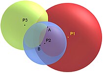
distancesposition coordinatesgeopositioningEuclidean distancesslant rangesspherical distancescentral anglestrue-range multilaterationpseudo-rangespseudo-range multilaterationtriangulationanglesdirection findingdirectionradial distancegeometrycirclesspherestrianglesrangessurveyingnavigationsurveillancespherical rangescelestial navigationtwo-dimensional geometrytimes-of-arrivaldetermining the positiontimes of flighttimes of arrivaltimes of transmissionhyperbolic navigationalgorithmtime difference of arrivalsWayback Machine