Tennessee State Route 158
Serving as the primary means of access to facilities such as Neyland Stadium and Thompson–Boling Arena, the route experiences congestion on game days, with a contraflow lane reversal implemented to mitigate this.[4] It also serves as a spur into downtown and provides access to a number of local landmarks and historic sites, including the Blount Mansion and James White's Fort.[8] SR 158 begins as a secondary highway known as Neyland Drive at an intersection with Kingston Pike on the western edge of the University of Tennessee (UT) campus.[9] The road passes by the UTK Sorority Village before meeting the north bank of the Tennessee River and running alongside a Norfolk Southern Railway track.[10] The route then turns southeast and passes underneath the J. E. "Buck" Carnes Bridge, which carries US 129 (Alcoa Highway), a major freeway in Knoxville, across the river.The road passes by a number of other UT facilities, including the university's veterinary school, before gradually turning east along the State Botanical Garden of Tennessee and crossing Third Creek.SR 158 then passes directly under the Gay Street Bridge, where the controlled-access portion begins at an eastbound-only exit for Volunteer Landing, a public park.[9][11] Turning sharply north, the highway transitions away from the riverbank, passes by the Blount Mansion and James White's Fort, and underneath the Hill Avenue Bridge.On October 23, 1950, Tennessee Governor Gordon Browning instructed state highway commissioner Charles F. Wayland Jr. to begin work on a two-lane extension of Front Street, initially known as Lakefront Drive, to Kingston Pike.[40] After multiple weather-related delays, this section opened to traffic on September 15, 1973,[3] and was dedicated in a ceremony by Governor Winfield Dunn and Knoxville Mayor Kyle Testerman four days later.The eastern terminus of SR 158 with I-40 quickly developed a high crash rate, largely due to left-hand entrance and exit ramps on I-40 westbound.[57][58] The northern portion of this stretch was widened, the Church Avenue bridge was replaced with the transit center viaduct, and a new ramp from I-40 eastbound to SR 158 westbound was constructed.[64] From March 1997 to January 2000, a connector between SR 158 and the South Knoxville Bridge was constructed, requiring expansion of the interchange with Hall of Fame Drive and Cumberland Avenue.[66] Between April 2015 and August 2017, the city of Knoxville undertook a streetscaping project which transformed a short stretch of Cumberland Avenue east of the western terminus of SR 158 from an urban thoroughfare into a pedestrian and bike friendly corridor.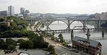


US 11US 70KnoxvilleUS 129SR 450SR 71United StatesTennesseeTennessee State RoutesInterstateSR 157SR 159state highwayKingston PikeTennessee RiverInterstate 40controlled-access highwaybypassdowntown KnoxvilleUniversity of TennesseeNeyland StadiumThompson–Boling Arenacontraflow lane reversalBlount MansionJames White's FortNational Highway Systemannual average daily trafficmulti-use trailNorfolk Southern Railwaypartial cloverleaf interchangeat-grade crossingrailroad spurTennessee Volunteers basketballTennessee Volunteers footballHenley Street BridgeUS 441Knoxville City-County BuildingKnox CountyGay Street BridgeVolunteer LandingKnoxville Area Transitsemi-directional T interchangeFourth and GillRobert NeylandUnited States Armybrigadier generalJames WhiteAmerican Revolutionary WarThe Knoxville News-SentinelCharles McClungInterstate Highway SystemTennessee GovernorGordon BrowningFederal-Aid Highway Act of 1956Federal Highway AdministrationTennessee Department of TransportationJohn Duncan Sr.culvertU.S. Secretary of TransportationJohn A. VolpeWinfield DunnKyle Testerman1982 World's Fairenvironmental impact statementAmerican Association of State Highway and Transportation Officialspedestrian and bike friendly corridorSR 115MaryvilleSignalized intersectionKnoxville Civic ColiseumWilliam Blount MansionJames White FortNashvilleAshevilleConcurrencyNewspapers.comEast Tennessee Historical SocietyGoogle BooksRothrock, Mary U.Wikimedia CommonsMeasuringWorthGross Domestic Product deflatorWBIR-TV