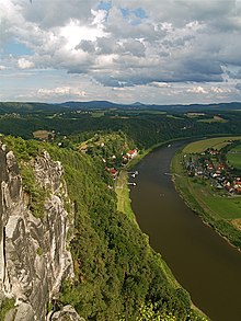
Saxon Switzerland
Previously, the Saxon part of the Elbe Sandstone Mountains had merely been referred to as the Meißner Hochland, Meißen Oberland or Heide über Schandau.This description does not, however, include the dome-shaped Kuppen such as the Waitzdorfer Höhe or the Großer Winterberg, whose bedrock is made of volcanic basalt or granitic material.Initially the larger table hills (Lilienstein), or those already deeply fissured like Zirkelstein, Kaiserkrone or already forested (Kohlbornstein), remained, but these too broke up later as a result of erosive destruction into long ridges (Schrammsteine) or even into individual rock pinnacles (Torwächter).[9] When Germans began to settle in the 13th century, there was a systematic banishment of Bohemian influence and numerous local military conflicts erupted around strategically important fortifications.The progressive division of the area due to the hereditary distribution of estates upset the economic balance of the region and many castles degenerated into bases for robber barons.In September 1990, even before the reunification of Germany, a national park was created in Saxon Switzerland in order to protect the unique natural character of the hill range.The 93 km2 area covers two physically separate regions: one near Rathen – the region of the Bastei, Polenz valley, Brand and Uttewalder Grund – and the other embracing the whole Saxon Switzerland Hinterland (Hintere Sächsische Schweiz) between the Elbe and the state border with the Czech Republic and including the Schrammsteinen, Großer Winterberg, Großer Zschand and Kirnitzsch valley.A Boofe (plural: Boofen) is local slang for sleeping out overnight in the open under a rock overhang and has a long tradition in Saxon Switzerland.However the growing number of Boofers and the bad conduct of individuals (e.g. who light illegal campfires, tear up saplings or cause soil erosion) has led to repeated altercations.


Sächsische Schweiz (district)Saxon, SwitzerlandElbe Sandstone MountainsGroßer ZschirnsteinBad SchandauSebnitzRathenSächsische Schweiz-OsterzgebirgeSaxonyGermanyBasteiPapststeinGohrischKönigstein FortressLiliensteinBarbarinePfaffensteinGermanclimbing areanational parkDresdenBohemian SwitzerlandCzech RepublicKönigsteinAdrian ZinggAnton GraffDresden Academy of ArtSwiss JuraLusatian HighlandsOre Mountainsabove sea levelnatural regionsSaxon-Bohemian Chalk Sandstone RegionZittau MountainsLusatian MountainsSaxon Academy of SciencesLeipzigSaxon Highlands and UplandsVogtlandGroßer WinterbergvolcanicbasaltgraniticCretaceoussandstonepeneplainTertiarytable hillsZirkelsteinKaiserkronerock pinnacleskarstificationBohemiaMiddle AgesBohemianSaxon hegemonyMargraviate of MeissentrolleybusBiela Valley TrolleybusRomanticpainterLudwig RichtercomposerCarl Maria von WeberDer FreischützNazi eraOttendorfPorschdorfRathmannsdorfReinhardtsdorfrobber baronsWettinsHohnsteinNeurathenAltrathenFalkensteinFriensteinSaxon Switzerland National Parkreunification of GermanyPolenz valleySchrammsteinenGroßer ZschandKirnitzschSaxon Switzerland climbing regionrock climbingfree climbingsafetyfriendsaid climbinggrades of difficultysure-footednesshead for heightsRotkehlchenstiegeSchmilkaKirnitzschtal TramwayNeurathen CastleBärensteineRauensteinBiela ValleyWehleninterurbanKuhstallSchrammsteineObere SchleuseHinterhermsdorfRathen Open-Air StageWolfsbergbotanical gardenHohnstein CastleRosenbergAffensteineZschirnsteineKleinenGroßen ZschirnsteinÚstí nad LabemLokomotiveHoher SchneebergEastern Ore MountainsList of regions of SaxonyWayback Machine