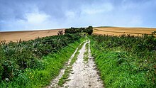
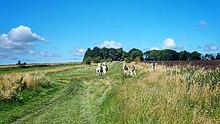
Ridgeway (road)
Prehistoric roads in Europe often variously comprised stretches of ridgeway above the line of springs, sections of causeway through bog and marsh, and other trackways of neither sort which crossed flat country.In western Europe, where prehistoric roads have been extensively documented with the help of itineraries, traces on old maps and extant marks on the landscape, ridgeways are a typical feature of long-distance ancient routes through rugged, high-rainfall parts of Germany and across the island of Great Britain.[2] In rugged parts of central Germany, ridgeways tend to strictly follow the watershed line proper, since traversing steep slopes was difficult for wheeled vehicles and uncomfortable for foot travellers unless someone had cut a track into the hillside and shored it up against washouts and slips.[3] On flatter British hills, the line of the tracks often runs a little below the actual crest of the ridge, possibly to afford some shelter from the wind or to avoid travellers presenting themselves to marauders as a target on the skyline.Since ridgeways were informal routes, and the rounded tops of many British and German ridges might be hundreds of metres wide, the track might change seasonally, or spontaneously, if any land alongside the trail appeared drier and firmer.From the 19th century onwards, old ridgeways which had not been converted into highways were often revived by hiking clubs or tourism authorities, marked out as scenic trails for walking, horse-riding or mountain biking far from the disturbances of motor traffic.Examples include the Kammweg established in 1904 in eastern Germany and the 197-kilometre Wessex Ridgeway in England, devised in the 1980s by the Ramblers Association, following ridges between the Atlantic coast and Avebury, with a preference for firm paths, good scenery and free access.


ridgestoll roadscausewayThe RidgewayNational Traillong-distance footpathssoil creepsubsoilancient trackwaysdrovers roadsenclosuresAveburyStreatleyIcknield WayChiltern HillsShaftesburyBlandfordSalisburyArnsberg ForestRennsteigAfghanistan-Pakistan bordermeanderRomansmacadamBritonsWagon TrailsMissouri RiverOregonCaliforniaRidgewayRyknild Streethollow waydebrisBaedekerKammwegWessex RidgewayRamblers AssociationAncient trackwayFord (crossing)Drainage divideList of ancient roadsTrade routeSalt roadOxford English DictionarySociety of Antiquaries of Newcastle upon Tyne