Terrain
The most common examples are used to derive slope or aspect of a terrain or curvatures at each location.Climatic parameters are based on the modelling of solar radiation or air flow.The most typical examples airlines of watersheds, stream patterns, ridges, break-lines, pools or borders of specific landforms.A digital elevation model (DEM) or digital surface model (DSM) is a 3D computer graphics representation of elevation data to represent terrain or overlaying objects, commonly of a planet, moon, or asteroid.DEMs are used often in geographic information systems (GIS), and are the most common basis for digitally produced relief maps.
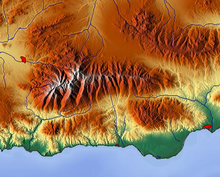

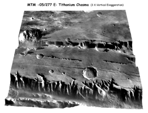
Terrain (disambiguation)TerranealtimetrybathymetryNational Geophysical Data CenterSierra NevadaShuttle Radar Topography Missionelevation modelAlpine FaultescarpmentmountainsSouthern Alpsdimensionphysical geographyelevationweatherclimatehypsometrysea levelalluvial plainsenvironmental qualityagriculturehydrologywatershed boundariesdrainage characteristicsdrainage systemsgroundwater systemswater movementhydrology transport modelsStorm Water Management ModelDSSAM Modelswater qualitysoil conservationContour ploughingsustainable agriculturemilitarilytroopshuman geographyhuman terrainprecipitationrain shadowaviationsee terrain collision avoidanceradio navigationaerodromelandscapeuplandgradientinter aliaGeomorphologygeological timeGeologicaltectonic platesfaultingfoldingmountain formationvolcanic eruptionsmass movementlandslidesdownhill creepslumpsExtraterrestrialmeteoriteimpactsTectonicorogeniesupliftsweatheringerosion and tectonicsmorphometricaspecthydrological parametersClimaticsolar radiationlandformswatershedsstreamridgesbreak-linesDigital elevation model3D renderingTithonium Chasma3D computer graphicsplanetasteroiddiscrete global gridgeographic information systemsrelief mapscanopybuildinglandscape modelingcity modelingland-use studiesplanetary scienceCartographic relief depictionGeographic information systemGeomorphometryIsostasyPhysical terrain modelRelief ratioSubterraneaTerrain awareness and warning systemTopographyAcademic PressU.S. Geological SurveyPearsonGoogle BooksTectonophysicsBibcodeGeological Society of AmericaUniversity of CologneScienceDailyEnvironment AgencyTectonicsScienceDerek Gregory