Radio navigation
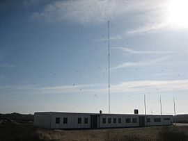
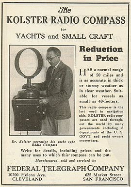
[citation needed] These systems used some form of directional radio antenna to determine the location of a broadcast station on the ground.A number of improved versions followed, replacing the mechanical motion of the antennas with phasing techniques that produced the same output pattern with no moving parts.[citation needed] A great advance in the RDF technique was introduced in the form of phase comparisons of a signal as measured on two or more small antennas, or a single highly directional solenoid.Combined with the introduction of the transistor and integrated circuit, RDF systems were so reduced in size and complexity that they once again became quite common during the 1960s, and were known by the new name, automatic direction finder, or ADF.As the LF/MF signals used by NDBs can follow the curvature of earth, NDB has a much greater range than VOR which travels only in line of sight.The frequency band allotted to non-directional beacons is 190–1750 kHz, but the same system can be used with any common AM-band commercial station.[citation needed] VHF omnidirectional range, or VOR, is an implementation of the reverse-RDF system, but one that is more accurate and able to be completely automated.These systems were common in the era when electronics were large and expensive, as they placed minimum requirements on the receivers – they were simply voice radio sets tuned to the selected frequencies.[citation needed] In the post-World War I era, the Lorenz company of Germany developed a means of projecting two narrow radio signals with a slight overlap in the center.[citation needed] Originally known as "Ultrakurzwellen-Landefunkfeuer" (LFF), or simply "Leitstrahl" (guiding beam), little money was available to develop a network of stations.Bombers would enter one of the beams and use it for guidance until they heard the second one in a second radio receiver, using that signal to time the dropping of their bombs.[citation needed] The ground stations consisted of a set of four antennas that projected two overlapping directional figure-eight signal patterns at a 90-degree angle to each other.Effective course accuracy was about three degrees, which near the station provided sufficient safety margins for instrument approaches down to low minimums.[citation needed] Early radar systems, like the UK's Chain Home, consisted of large transmitters and separate receivers.The transmitter periodically sends out a short pulse of a powerful radio signal, which is sent into space through broadcast antennas.Electronics attached to the oscilloscope provides a signal that increases in voltage over a short period of time, a few microseconds.As the distance between the broadcaster and receiver grows, the area covered by the fan increases, decreasing the accuracy of location within it.Unlike Y-Gerät, Oboe was deliberately built to offer very high accuracy, as good as 35 m, much better than even the best optical bombsights.[citation needed] The British put this concept to use in their Rebecca/Eureka system, where battery-powered "Eureka" transponders were triggered by airborne "Rebecca" radios and then displayed on ASV Mk.Beacons were widely used for temporary or mobile navigation as well, as the transponder systems were generally small and low-powered, able to be man portable or mounted on a Jeep.The name refers to the fact that they do not produce a single distance or angle, but instead indicate a location along any number of hyperbolic lines in space.As these systems are almost always used with a specific navigational chart with the hyperbolic lines plotted on it, they generally reveal the receiver's location directly, eliminating the need for manual triangulation.As these charts were digitized, they became the first true location-indication navigational systems, outputting the location of the receiver as latitude and longitude.Gee remained in use long after World War II, and equipped RAF aircraft as late as the 1960s (approx freq was by then 68 MHz).They turned their development efforts towards a much longer-ranged system based on the same principles, using much lower frequencies that allowed coverage across the Atlantic Ocean.However, this was far easier to display; the system could output the phase angle to a pointer on a dial removing any need for visual interpretation.LORAN-C (the original retroactively became LORAN-A) combined the techniques of pulse timing in Gee with the phase comparison of Decca.[citation needed] The resulting system (operating in the low frequency (LF) radio spectrum from 90 to 110 kHz) that was both long-ranged (for 60 kW stations, up to 3400 miles) and accurate.By the late 1970s, LORAN-C units were the size of a stereo amplifier and were commonly found on almost all commercial ships as well as some larger aircraft.[citation needed] Satellite navigation systems offer better accuracy than any land-based system, are available at almost all locations on the Earth, can be implemented (receiver-side) at modest cost and complexity, with modern electronics, and require only a few dozen satellites to provide worldwide coverage[citation needed].

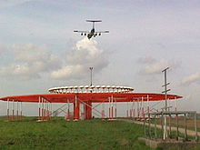

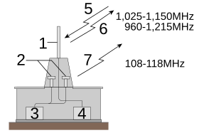
1 DME; 2 VOR
Radionavigation land stations
radio wavesdetermine a positionradiolocationradiodeterminationelectric beaconsAngular directionsDistancesrangingtime of flighttimes of arrivalvelocityDoppler shiftradio fixAmelia EarhartLockheed ElectraRadio direction finderradio stationdirectional antennatriangulationintersectionAM radioradio beaconsairportsloop antennaWorld War IWorld War IImorse codeTelefunken Kompass SenderZeppelinOrfordness BeaconNon-directional beaconsolenoidtransistorintegrated circuitautomatic direction finderVHF omnidirectional rangeairwayLorenz beamblind landingInstrument Landing SystemBattle of the BeamsUnited Kingdomintelligence serviceselectronic warfareLow frequency radio rangeinstrument flyinginstrument approachesairwaysInstrument landing system glide pathInstrument landing system localizerTransponderTransponder landing systemChain HomeoscilloscopeY-GerätbombsightsElectric beaconRAF Coastal CommandRebecca/EurekaUS MarinesDistance measuring equipmentTactical air navigation systemHyperbolic navigationnavigational chartGee (navigation)RAF Bomber CommandbombersAtlantic OceanDecca Navigator SystemLoran-Clow frequencyintegrated circuitsOmega Navigation Systematomic clockSatellite navigationsatellite navigation systemsdifferential GPSInternational Telecommunication Union'sRadio Regulationsradionavigationsafety-of-life serviceInterferencesNavigationradiocommunication serviceRadiodetermination serviceRadiodetermination-satellite serviceRadionavigation-satellite serviceMaritime radionavigation serviceMaritime radionavigation-satellite serviceAeronautical radionavigation-satellite serviceHannover AirportDeisterinterferenceInternational Telecommunication Union´sITU Radio RegulationsRadiodetermination stationRadionavigation mobile stationILS glide pathILS LocalizerVORTACShemya, AlaskaAmbrose Channel pilot cableAmerican Practical NavigatorGalileo positioning systemGlobal Positioning SystemGlobal Navigation Satellite SystemInertial navigation systemLocal Area Augmentation SystemLong-range navigationMarker beaconMicrowave landing systemMultilaterationRadio altimeterRadar navigationReal-time locatingReceiver Autonomous Integrity MonitoringSpace Integrated GPS/INSSCR-277Tactical air navigationTransit (satellite)X-ray pulsar-based navigationWide Area Augmentation SystemWind triangleRadio stationsTerrestrial stationEarth station