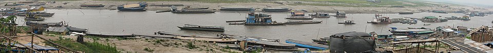
Pucallpa
According to the Instituto Nacional de Estadística e Informática, it is the tenth most populated city in Peru and second largest in the Peruvian Amazon after Iquitos.The Federico Basadrees highway is the main center of land transportation and connects the northwest of the city with the Captain Rolden International Airport (Aeropuerto Internacional Capitán FAP David Abensur Rengifo), where flights are made to Brazil.Sometimes the Shipibo territory is considered to be downstream of the Ucayali and the Conibo culture upstream, but in reality there are communities of both groups in the two areas because they have mixed with each other.In 1779 Pucallpa was part of the Municipality of Trujillo that came to have nine parties that were Trujillo, Lambayeque, Piura, Cajamarca, Huamachuco, Chota, Moyobamba, Chachapoyas, Jaén and Maynas, this last party previously made up the departments of what is known today such as (Department of San Martín, Ucayali, Loreto) with the Municipality of Trujillo being the largest in the Viceroyalty of Peru, that is, almost all of northern Peru today; Its first mayor was Fernando Saavedra from 1784 to 1791.After this he would be followed by Vicente Gil de Taboada (1791-1805 and 1810-1820), Felice del Risco y Torres (provisional) (1805-1810) and the marquis of Torre Tagle (1820), who led the independence of the Municipality.It was part of the Government of the General Command of Maynas, which was a territorial division of the Spanish Empire in the Viceroyalty of Peru, created by a royal decree of July 15, 1802.[4] For several decades it remained a small settlement as it was isolated from the rest of the country by the Amazon rainforest and the Andes mountain range.The identity of the founder is discussed by the municipality, since the honor is attributed to three people: the Peruvian Eduardo del Águila Tello (born in San Martín) or the Brazilians Agustín Cáuper Videira and Antonio Maya de Brito, who, although unknown, are popular today.At the moment, a fixed founding date has not been established, because it was not the product of an act of settlement, but rather of a gradual process of population and cantonment of settlers.Oral sources indicate that, starting in the 1850s, the first settlers began to arrive in this town, although a small native settlement already existed.From the 1880s through the 1920s a railway project to connect Pucallpa with the rest of the country via the Ferrocarril Central Andino was started and dropped several times until it was finally abandoned.However, the heavy rainfalls of the Amazon rainforest remain a problem as they erode the highway and can even undermine it by causing flash floods.Pucallpa is served by air through the Captain Rolden International Airport and by river through its port Pucallpillo near the center of the city.The Municipal Drinking Water and Sewerage Company of Coronel Portillo (Español: La Empresa Municipal de Agua Potable y Alcantarillado de Coronel Portillo) is the main company in water management, beginning operation on 1 July 1992.The company aims to carry out all activities related to the provision of public drinking water and sewerage service in the area of the Province of Coronel Portillo through its headquarters in the east of Pucallpa.[citation needed] This company is located in the eastern part of the country, and its activities correspond to an isolated electrical system in the same region.[18] In architectural terms, the great changes in the form of rural housing in Pucallpa and its organization are due to indigenous contact with modern society.In the immense variety, the paiche stands out, the second largest freshwater fish (can weigh up to 300 kilos and measure more than 2.5 meters long).In the city the predominant religion is Christianity, whose greatest tradition is the festival of San Juan, and in rural areas it can be native, especially as a local custom.The main sports venue for playing football is the Estadio Aliardo Soria Pérez, located in the center of the city, with capacity for 25,000 spectators.This work is unfinished, as it is not fully paved, despite being very busy, as it is the means of land transportation to several towns in the north of Ucayali.For example, in the past, the constant humidity in the rainy cycle has led to the detection of dengue hemorrhagic fever in the Manantay district.The most dangerous crimes are drug trafficking on the Federico Basadre highway,[31] and water based river assaults, as these increase transportation vulnerability.


UcayaliCoronel PortilloTime zoneQuechuaShipiboUcayali RiverAmazon RiverUcayali regionCoronel Portillo ProvinceCalleria DistrictmetropolisInstituto Nacional de Estadística e InformáticaPeruvian AmazonIquitosdistrict of CalleríaconurbationPuerto Callaodistrict of Yarinacochadistrict of ManantayAmazonCaptain Rolden International AirportBraziltimber industryecological tourismcultural tourismshamanismtimber extractionPachitea RiverCurimaná DistrictPerené RiverBoliviaSheteboContamanaMunicipality of TrujilloTrujilloLambayequeCajamarcaHuamachucoMoyobambaChachapoyasMaynasDepartment of San MartínLoretoViceroyalty of PeruSpanish EmpireFranciscanShipibo-ConiboAmazon rainforestFerrocarril Central AndinoTingo Mariaflash floodsHuánucoCerro de PascoSan Lorenzo Megaport ProjectAtlanticCampoverdeKöppen climate classificationrelative humidityDeutscher WetterdienstCalleríaYarinacochaManantaymalocaImmaculate Conception CathedralChristianityShining PathCatholicismfootballSport LoretoDeportivo PucallpaDeportivo BancosEstadio Aliardo Soria PérezFAP Captain David Abensur Rengifo International AirportTarapotoLeticiaManantay districtTapiche Ohara's ReserveTANS Peru Flight 204LANSA Flight 508YarinaquchaPeruvianArequipaAyacuchoCallaoChiclayoChimboteChinchaHuachoHuancayoHuarazJuliacaSullanaTalaraDepartmentAmazonasAncashAbancayApurímacHuancavelicaJunínLa LibertadDepartment of LimaPuerto MaldonadoMadre de DiosMoqueguaSan MartínTumbes