Olympic Mountains
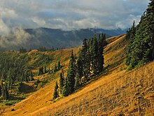
The mountains are located in western Washington in the United States, spread out across four counties: Clallam, Grays Harbor, Jefferson and Mason.The Olympics have the form of a domed cluster of steep-sided peaks surrounded by heavily forested foothills and incised by deep valleys.Clockwise from windward to leeward, the major watersheds are: Satsop, Wynoochee, Humptulips, Quinault, Queets, Hoh, Bogachiel, Sol Duc (all flowing west into the Pacific Ocean; with the Satsop, Wynoochee by way of the Chehalis River, the Humptulips by way of Grays Harbor at the mouth of the Chehalis River, and the Bogachiel and Sol Duc forming the Quillayute River within 5 miles (8.0 km) of tidewater), Lyre, Elwha, Dungeness (all flowing north into the Strait of Juan de Fuca), Big Quilcene, Dosewallips, Duckabush, Hamma Hamma, and Skokomish (all flowing east into Hood Canal).[10] 140 to 170 inches (3,600 to 4,300 mm) of rain falls on the Hoh Rainforest annually,[11] receiving the most measured precipitation of anywhere in the contiguous United States.[13] Annual precipitation increases to about 30 in (760 mm) on the edges of the rain shadow around Port Townsend, the San Juan Islands, and the city of Everett across Puget Sound.The large number of snowfields and glaciers, reaching down to 1,500 m (5,000 ft) above sea level, are a consequence of the high precipitation, northern latitude, and cool moderating climate adjacent to the Pacific Ocean.[10] Millions of years ago, vents and fissures opened under the Pacific Ocean and lava flowed forth, creating huge underwater volcanic mountains and ranges called seamounts.During the Orting, followed by the Stuck, the Salmon Springs, and the Fraser glaciations, the vast continental Cordilleran Ice Sheet descended from Alaska south through British Columbia to the Olympics.[18] Along the western flanks of the mountains the increased orographic precipitation supports temperate rain forests in the Quinault, Queets, Hoh, and Bogachiel river valleys at low elevations.In this zone, despite the high annual precipitation, drought stress in summer is sufficiently severe to limit growth of many species, such as Sitka spruce.Drier areas or those with longer snow cover grow dwarf sedge (Carex nigricans) or grass (Festuca viridis) meadows.[18] The high precipitation of the Olympics creates permanent snow and ice at lower elevations than is typical for other mountain ranges, cutting off the alpine vegetation zone.Forest Service and State Game personnel were overwhelmed with rescue efforts (lost, stranded, or injured hunters) and dispute resolution.Blacktail deer (Odocoileus hemionus columbianus) prefer drier areas than elk, such as the dry western hemlock, Douglas-fir, and subalpine fir zones.The majority of spotted owls on the Olympic peninsula, along with the largest preserve of temperate old-growth forest, live in the national park.People in the Skokomish, Quinault, and Elwha watersheds regularly traveled into the high country to hunt elk, gather huckleberries and beargrass, and perform spirit quests.In addition, a fragment of a woven basket found in the Olympic subalpine of Obstruction Point was radiocarbon dated to nearly 3000 years ago.[10][34] The mountains were originally called "Sun-a-do" by the Duwamish Indians,[35] while the first European to see them, the Spanish navigator Juan Pérez, named Mount Olympus "Santa Rosalia", in 1774.[35] Though readily visible from many parts of western Washington, especially Seattle, the interior was almost entirely unexplored until 1885, when 2nd Lt. Joseph P. O'Neil of the 14th Infantry, stationed at Fort Vancouver, led a small expedition into the northern Olympics from Port Angeles.The expedition cut a mule trail from Port Angeles up to Hurricane Ridge and camped near the current site of the national park visitor center.[5][33] In late 1889, Charles A. Gilman and his son Samuel explored the East Fork Quinault up to its headwaters, but chose to return the way they came rather than cross over the mountains.Once on the Quinault side of the divide, the men shot and ate a bear, the first meat they had had for several weeks of strenuous winter mountain travel.It took the expedition four months of slogging through dense brush and windthrows, swamps, steep canyons and deep, wet, slushy snow just to reach the inner mountains.[33] The settler and neighboring Indians took the expedition across Lake Quinault and down the lower river to the coast in mid May, nearly six months after they left Port Angeles.The Elwha River and North Fork Quinault trails in Olympic National Park follow the route of the Press Expedition, with a detour through the highest mountains and around the vertical cliff at Low Divide.The scouts and side exploring parties scrambled up slopes on all fours, pulling themselves up by grabbing onto vegetation; descended similar slopes by sliding, deliberately or inadvertently; hacked and crawled through dense brush and windthrow; waded up rivers and streams when there was no other way through; felled trees to bridge ravines and rivers; and traversed narrow ridges of crumbling vertically oriented shale.Hornet and yellow jacket wasp attacks were a daily occurrence, sending men scrambling and mules stampeding, one over a cliff to her death.In 1914, the new supervisor of the Forest Service, Henry Graves, made a trip to the Olympics to determine if commercial timber and minerals were being tied up in the national monument.[5][44] Migrating salmon are trucked around the dam, and Tacoma Public Utilities funds mitigation for Roosevelt elk wintering habitat that was lost under the reservoir.During the Great Depression, the Olympic National Forest used the Civilian Conservation Corps to build logging roads and railroads, bridges, campgrounds, shelters, fire lookouts, ranger stations, and a fish hatchery.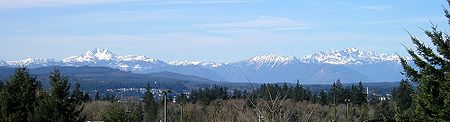


Mount OlympusElevation NAVD 88ListingMountain ranges in WashingtonCoordinatesWashingtonClallamGrays HarborJeffersonOlympic National ParkOlympic National ForestRange coordinatesParent rangemountain rangeOlympic PeninsulaPacific NorthwestmountainsPacific Coast RangesPuget SoundPacific Oceancoastal plainPacific Border provincedouble peakSatsopWynoocheeHumptulipsQuinaultQueetsBogachielSol DucChehalis RiverQuillayute RiverDungenessStrait of Juan de FucaBig QuilceneDosewallipsDuckabushHamma HammaSkokomishHood CanalMount AndersonQuinault RiverMount ConstanceMount TownsendBuckhorn WildernessWest PeakhydrographicThe BrothersMount DeceptionMount WashingtonMount AngelesMount StoneMount EllinorBoulder PeakElwha RiverMount Storm KingLake CrescentHurricane RidgeBailey RangeLost PassDaniel J. Evans WildernessHoh Rainforestrain shadowglaciersMount CarrieMount ChristieMount QueetsobductedclasticEoceneturbiditesbasalticCascadesseamountsFarallontectonic platePleistocenealpinecontinentalcirquesCordilleran Ice SheetJuan de Fucaglacial erraticsmadronetropical cyclonesBogachiel riverSitka sprucewestern hemlockbigleaf maplevine maplemoss layerRoosevelt elksilver firmountain hemlockDouglas-firred alderred-cedarSlide alderyellow-cedarthimbleberrysubalpine firSitka valerianshowy sedgeCarex nigricansPhlox diffusaAmerican saw-wortViola flettiiPiper's bellflowerSpotted coralrootFlett's fleabaneQuinault fawn lilyOlympic violetfishergray wolfcoyotesOlympic marmotAmerican black bearCougarmountain goatRussian RiverVancouver IslandRocky Mountain elkBlacktail deerMountain beaverBanana slug