Nakatsugawa
Mount Ena, the southernmost of the Kiso Mountains on the border between Nakatsugawa, Aichi and Nagano Prefecture is the highest point in the city, with an elevation of 2,191 metres (7,188 ft).[3] Per Japanese census data,[5] the population of Nakatsugawa peaked around the year 2000 and has declined since.In the post-Meiji restoration cadastral reforms, Ena District in Gifu prefecture was created, and Nakatsugawa was proclaimed a town per the April 1, 1897 establishment of the modern municipalities system.Nakatsugawa merged with the town of Naegi in 1951 and was elevated to city status on April 1, 1952.[6] Nakatsugawa has a mayor-council form of government with a directly elected mayor and a unicameral city legislature of 24 members.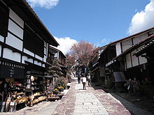
CountryRegionChūbuPrefectureTime zoneJapan Standard TimeClimateEnkianthus campanulatusSciadopitys verticillataMagome-jukupopulationpopulation densityTōnōMount EnaKiso MountainsKiso RiverAgi RiverKöppen climate classificationprecipitationsunshine hoursJapan Meteorological AgencyGifu PrefectureHigashishirakawaShirakawaNagano PrefectureHirayaŌkuwaŌtakiMino ProvinceEdo periodOwari DomainNaegi DomainIwamura DomaintenryōTokugawa shogunateNakatsugawa-juku69 Stations of the NakasendōNakasendōMeiji restorationEna DistrictTsukechiFukuokaSakashitaHirukawaKashimoKawaueYamaguchiKiso Districtmayor-councilunicameralChukyo Gakuin UniversityNagoya UniversityJR CentralChūō Main Line Ochiaigawa NakatsugawaMino-SakamotoAkechi RailwayIinumaChūō ExpresswayNational Route 19National Route 256National Route 257National Route 363RegistroSão PauloBrazilKomoroNaganoKanagawaMisaka PassTakamine CoJunji ItoSeison MaedacapitalCore cityHashimaKakamigaharaMinokamoMizuhoMizunamiMotosuŌgakiTajimiTakayamaYamagataAnpachi DistrictAnpachiWanouchiFuwa DistrictSekigaharaHashima DistrictKasamatsuIbi DistrictIbigawaKamo DistrictHichisōKawabeSakahogiTomikaYaotsuKani DistrictMitakeMotosu DistrictKitagataŌno DistrictYōrō DistrictYōrōList of mergers in Gifu Prefecture