Parallel 36°30′ north
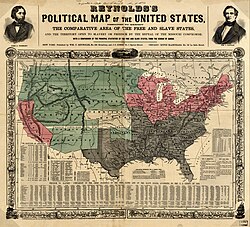
This parallel of latitude is particularly significant in the history of the United States as the line of the Missouri Compromise, which was used to divide the prospective slave and free states east of the Mississippi River, with the exception of Missouri, which is mostly north of this parallel.The line continues to hold cultural, economic, and political significance to this day; the Kinder Institute for Urban Research defines the Sun Belt as being south of 36°30′N latitude.Due to the relative precision of the survey of 36°30′ on the Mississippi River, Congress decided to continue the line west as the northern boundary of Arkansas Territory, with the exception of the Missouri Bootheel.The Missouri Compromise of 1820 established the latitude 36°30′ as the northern limit for slavery to be legal in the territories of the west.Also Maryland, another slave state, was occupied by the Union Army under the commands of President Abraham Lincoln, and its legislature was thus pressured into voting not to secede.Naturally, Lincoln and the remaining members of the U.S. Congress wanted Maryland to stay in the Union in order to prevent the national capital city of Washington, D.C. from being surrounded by Confederate states, and hence being cut off from the rest of the Union.
U.S. territoriescircle of latitudedegreesequatorhistory of the United StatesMissouri Compromiseslave and free statesMississippi RiverMissouriSun BeltUnited StatesTennesseeKentuckyTennessee RiverArkansasSt. Francis RiverOklahoma PanhandleTexas PanhandleVirginiaNorth CarolinaRoyal Colonial Boundary of 1665Colony of VirginiaProvince of CarolinaArkansas TerritoryMissouri BootheelEast Coast of the United States36th parallel northMassachusettsU.S. SenateplanterscottonSouthern United StatesMichiganWisconsinFloridaRepublic of TexasFederal GovernmentKansasColoradoNew MexicoCompromise of 1850New Mexico TerritoryUtah TerritoryKansas TerritoryColorado Territory37th parallel northArizona13th AmendmentNo Man's LandNevadaLas VegasArizona TerritoryCaliforniaCalifornia Gold RushAmerican Civil WarConfederate States of AmericaMarylandUnion ArmyAbraham LincolnU.S. CongressWashington, D.C.PhiladelphiaPrime MeridianMediterranean SeaAlgeriaTénèsHéliopolisTunisiaSicilyGreeceMani PeninsulaElafonisosCape MaleaAegean SeaFolegandrosSantoriniAstypalaiaNisyrosRhodesTurkeyGulf of AntalyaGulf of İskenderunAl-HasakahQaemshahrTurkmenistanAfghanistanPakistanKhyber PakhtunkhwaGilgit-BaltistanXinjiangQinghaiXiningNingxiaShaanxiShanxiShandongYellow SeaAnmyeon IslandSouth KoreaCheonsu BaySouth Chungcheong ProvinceSejong CityDaejeonNorth Chungcheong ProvinceCheongjuMount SongniNorth Gyeongsang ProvinceAndongSea of JapanHonshūIshikawa PrefectureToyama PrefectureNagano PrefectureGunma PrefectureTochigi PrefectureIbaraki PrefecturePacific OceanPoint LobosOklahomaKentucky BendClarksvilleAtlantic OceanCádizMarbellaTerritorial evolution of the United StatesMason–Dixon line