Mandara Mountains
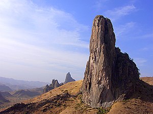
The Mandara Mountains are a volcanic range extending about 190 km (about 120 mi) along the northern part of the Cameroon–Nigeria border, from the Benue River in the south (9°18′N 12°48′E / 9.3°N 12.8°E / 9.3; 12.8) to the north-west of Maroua in the north (11°00′N 13°54′E / 11.0°N 13.9°E / 11.0; 13.9).[3] The Mandara Mountains were formed millions of years ago when a continental plate of basement rock deep beneath the African continent rose up, fragmenting and splitting as it was pushed to the surface.The climate was significantly wetter in those times, so enormous amounts of precipitation formed numerous rivers that rushed through these fractures, carving them deeper and wider, resulting in the range's notably rugged terrain.Grasses form the understory The highest-elevation areas, from 1,200 to 1,494 meters elevation, are home to a mix of lowland (Sudanian) and montane and submontane (Afromontane) species, including some rare and endemic plants and reptiles.[5] Local people developed a system of intensive agriculture involving the construction of terraces and measures to retain and improve soil fertility.
Mount MandaraRhumsikiCameroon–Nigeria borderBenue RiverMarouaMount OupayChadicarchaeologicalDiy-Gid-Biycontinental platebasement rockrose upVolcanic activityvolcanic conesvolcanic plugsMandara Plateau mosaicIsoberlinia dokaAfromontanesorghummilletKhaya senegalensisAcacia albidaPico Cão GrandeTororo RockPlatesAfrican plateSomali plateLwandle plateMadagascar plateRovuma plateVictoria MicroplateCratonsshieldsArabian-Nubian ShieldCongo CratonKaapvaal CratonKalahari CratonSaharan MetacratonTanzania CratonTuareg ShieldWest African CratonZimbabwe CratonShear zonesAswa DislocationCentral African Shear ZoneFoumban Shear ZoneKandi Fault ZoneMwembeshi Shear ZoneOrogensAlpine OrogenCape Fold BeltDamara OrogenEast African OrogenEburnean OrogenGondwanide OrogenKibaran OrogenKuunga OrogenMauritanide BeltPan-African orogensTerra Australis OrogenAfar TriangleAnza troughBahr el Arab riftBenue TroughBlue Nile riftEast African RiftGulf of Suez RiftMelut BasinMuglad BasinRed Sea RiftUrema ValleyWest and Central African Rift SystemWhite Nile riftSedimentary basinsAngola BasinAoukarBlue Nile BasinChad BasinCongo BasinEl DjoufKaroo BasinIullemmeden BasinMurzuq BasinNiger Delta BasinOgaden BasinOuled Abdoun BasinOwambo BasinRio del Rey BasinSirte BasinTaoudeni BasinTindouf BasinTurkana BasinMountain rangesAïr MountainsAtlas MountainsAurès MountainsBambouk MountainsBlue MountainsCameroon lineCentral Pangean MountainsChaillu MountainsDrakensbergEastern Arc MountainsEastern Rift mountainsEthiopian HighlandsGreat EscarpmentGreat Karas MountainsGuinea HighlandsHoggar MountainsImatong MountainsJebel UweinatLoma MountainsMarrah MountainsMitumba MountainsNuba MountainsRif MountainsRwenzori MountainsSankwala MountainsSerra da LebaSerra da ChelaTeffedest MountainsTibesti MountainsInselbergsAnti-AtlasMount GorongosaJugurtha Tableland