Nova Scotia peninsula
The narrow and deep waters of the Strait of Canso separate the peninsula from Cape Breton Island, the second largest land mass constituting the province of Nova Scotia.The northern portion of the peninsula is dominated by the Avalon Uplands (the Cobequid Hills and Pictou-Antigonish Highlands) and the Carboniferous Lowlands, the latter of which straddles the fault zone.Throughout the northern portion of the peninsula, the lowland plains, rolling uplands, and coastal fringe areas support numerous settlements, many of which developed around mineral extraction, particularly coal.When included with the Sydney and Inverness coal fields on Cape Breton Island, these regions were extremely prominent in the industrial and social development of Nova Scotia.Prior to 1713, this territory was the heart of the French colony of Acadia, which focused its settlement efforts along the southern and northeastern shores of Baie Francois (now the Bay of Fundy).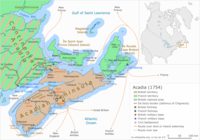
Nova ScotiaHalifaxTime zoneArea code(s)peninsulaAtlanticNorth AmericaMi'kmaw languageCanadaNew BrunswickIsthmus of ChignectoGulf of MaineBay of FundyNorthumberland StraitStrait of CansoCape Breton IslandBoularderie IslandBrier IslandLong IslandPictou IslandTancook IslandMinas BasinCobequid BayChedabucto BayCobequid HillsAppalachian MountainsCumberland CountyJogginsRiver HebertSpringhillDebertPictouSydneyInvernessSouth MountainAnnapolis ValleyDigby NeckYarmouthsea level risemicro-climateAcadian PeninsulaAcadiaTreaty of UtrechtGreat BritainAnticosti IslandGaspé PeninsulaPrince Edward IslandGulf of St. LawrenceMassachusettsGeography of Nova ScotiaMaritime PeninsulaGeology of Canadaprovince or territoryAlbertaBritish ColumbiaManitobaNewfoundland and LabradorOntarioQuebecSaskatchewanNorthwest TerritoriesNunavut