Magdalena Department
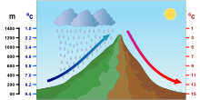
Magdalena (Spanish pronunciation: [maɣðaˈlena]) is a department of Colombia with more than 1.3 million people, located to the north of the country by the Caribbean Sea.The basin irrigates great extensions of the municipalities of Ciénaga, Zona Bananera, Fundación, Aracataca, and El Retén, which are the heart of the agricultural and livestock economy of the department.The permanent marshes are, Chilloa, La Rinconada, Tesca, Pijiño, Juan Criollo, Jaraba, Playa Afuera, Ciénaga Grande de Santa Marta, and Zapatosa.The altitude increase because of the Sierra Nevada de Santa Marta, an isolated mountain, the highest at sea level, and temperatures raise as it goes up.The presence of the Sierra Nevada in this area of the country has consequences in the climate of the department, the SNSM stands windward blocking the path of the Trade winds that blow from the North and Northeast creating a greater cloud accumulation and precipitation.The clouds that manage to pass over the mountain, move hastily downwards creating foehn winds that raise the temperature of the area west of the Sierra, which include the Santa Marta, and Ciénaga.The Mompox Depression presents its own climatic conditions due to its many permanent bodies of water, like the different ciénagas or mashes, and rivers and lakes.Amazonas Antioquia Arauca Atlántico Bolívar Boyacá Caldas Caquetá Casanare Cauca Cesar Chocó Córdoba Cundinamarca Guainía Guaviare Huila La Guajira Magdalena Meta Nariño N. Santander Putumayo Quindío Risaralda San Andrés Santander Sucre Tolima Valle del Cauca Vaupés Vichada


Magdalena (disambiguation)DepartmentSierra NevadaCoat of armsSpanish:ColombiaRegionCaribbean RegionEstablishedSanta MartaTime zoneUTC-05ISO 3166 codeMunicipalities22nd of 33Caribbean SeaMagdalena RiverUnited States of ColombianortheastLa Guajira DepartmentCesar DepartmentAtlanticoNorthwestBolívardrainage basinsSierra Nevada de Santa MartaCiénagaZona BananeraFundaciónAracatacaEl ReténarroyosCiénaga Grande de Santa MartaEl BancotributariesZapatosa MarshCauca RiverCesar RiverSan Jorge RiverAriguaní Riveranimal husbandryZapatosaClimateIntertropical Convergence Zonetropical climateocean currentsprecipitationatmospheric pressureTrade windsOrographic liftrelative humidityfoehn windskatabatic windssea breezesRainy seasondry seasonsolar radiationConvection rainsecoregionscloud forestsWorld Wide Fund for NatureEcoregionMagdalena Valley montane forestsNeotropicaltropical and subtropical moist broadleaf forestsMagdalena–Urabá moist forestsSinú Valley dry forestsSanta Marta montane forestsSanta Marta páramomontane grasslands and shrublandsMagdalena Valley dry foreststropical and subtropical dry broadleaf forestsGuajira–Barranquilla xeric scrubdeserts and xeric shrublandsMagdalena–Santa Marta mangrovesmangrovemunicipal mayormunicipal councilMunicipality of Santa MartaAlgarroboAriguaníCerro San AntonioChiboloConcordiaEl PiñónGuamalNueva GranadaPedrazaPijiñoPivijayPueblo ViejoRemolinoSabanas de San ÁngelSalaminaSan Sebastián de BuenavistaSanta AnaSan ZenónSitionuevoTenerifeZapayánQuinta de San Pedro AlejandrinoSimón BolívarTayrona National Natural ParkecosystemCasa de la AduanaCiudad PerdidaWorld Heritage Sitenatural monumentSierra Nevada de Santa Marta National ParkUnión MagdalenaFootballSovereign State of MagdalenaGovernorDepartments of the North of ColombiaDepartmentsCórdobaGuajiraSaint AndrewsMajor citiesBarranquillaCartagenaDepartmental capitalsMonteríaRiohachaSan AndrésSincelejo