[1] The shallow waters are used for salmon and mussel farms, crab and lobster creels as well as scallop diving.The mouth of Loch Bracadale (where it opens to the Atlantic) is some 3+3⁄4 miles (6 kilometres) wide, from Idrigill Point on the Duirinish Peninsula to Rubha nan Clach on the Minginish Peninsula.One-half mile (800 metres) west of Idrigill Point are the three sea stacks known as Macleod's Maidens.On the south-western shore of the loch, from Rubha nan Clach are impressive sea cliffs, some 100 metres (330 ft) high, dotted with caves and cascading waterfalls, up to Gob na h-Oa.Further eastwards Sgùrr nan Uan marks the westward side of Fiskavaig Bay which runs round to Ardtreck (from which Dun Ardtreck overlooks Loch Bracadale at grid reference NG33503581) to the now automated lighthouse at Ardtreck Point which sits opposite Bracadale Point (between Bracadale and Ullinish.)
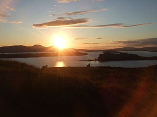
Looking Northwest from Fiskavaig across Loch Bracadale with the Oronsay, Wiay, Tarner Island, and Harlosh Island in order of distance