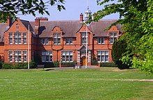
Shropshire
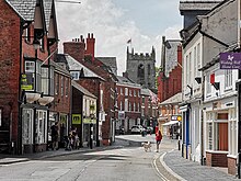
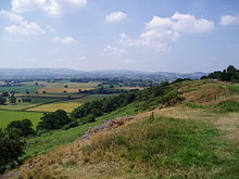
It is bordered by Cheshire to the north-east, Staffordshire to the east, Worcestershire to the south-east, Herefordshire to the south, and the Welsh principal areas of Powys and Wrexham to the west and north-west respectively.[10] The south-east is a sandstone plateau which forms part of the catchment of the Severn, the county's major river;[11] it enters Shropshire in the west and flows through Shrewsbury before turning south-west and exiting into Worcestershire south of Bridgnorth.[14] During the English Civil War Shropshire was Royalist, and Charles II fled through the county—famously hiding in an oak tree—after his final defeat at the Battle of Worcester.[22] Ptolemy's 2nd century Geography names one of their towns as being Viroconium Cornoviorum (Wroxeter), which became their capital under Roman rule and one of the largest settlements in Britain.Oswald was later regarded as a saint, with Bede saying that the spot where he died came to be associated with miracles, and people took dirt from the site, which led to a hole being dug as deep as a man's height.[26] King Offa of Mercia annexed the entirety of Shropshire over the course of the 8th century from Powys, with Shrewsbury captured in 778, with two dykes built to defend, or at least demarcate it from the Welsh.[27] King Offa converted the palace of the rulers of Powys into his first church, dedicated to St Chad (a foundation that still survives in the town and operated on that initial site for over 1000 years, moving in 1792).[29] In 914,[30][31][a] Æthelflæd, Lady of the Mercians, fortified Shrewsbury, along with two other fortresses, at Scergeat (a currently unknown location) and Weardbyrig,[b] Viking rides from the north traveling south were reaching Bridgnorth at this time (910CE).Also in this period, a number of religious foundations were formed, the county largely falling at this time under the Diocese of Hereford and that of Coventry and Lichfield.According to historian John Davies, at its peak under Sir Henry Sidney and for a period thereafter the Council: represented a remarkable experiment in regional government.It administered the law cheaply and rapidly; it dealt with up to twenty cases a day and George Owen stated that the 'oppressed poor' flocked to it.[47] In the High Medieval period the Shropshire area influenced important poetry: the poet William Langland, writer of Piers Plowman, was born in Cleobury Mortimer,[48][49] and the 14th-century alliterative poem St Erkenwald[50] is written in a local dialect.[59] Ludlow Castle site features heavily in the folk-story of Fulk FitzWarin, outlawed Lord of Whittington, Shropshire and a possible inspiration for the Robin Hood legend.This forest was the Setting of Shakespeare's As You Like It,[62][63] and that play is acknowledged to potentially be a cultural monument to Sir Rowland Hill, a prominent Tudor statesman and publisher of the Geneva Bible from the county.In Oscar Wilde's The Importance of Being Earnest, Algernon attempts to trick Jack into revealing the location of his country home by inferring he resides in Shropshire.Whitsuntide and mystery plays were performed in the founding years of Shrewsbury School under Thomas Ashton; they attracted the attention of Queen Elizabeth I.Later in life he came to publish on the subject of dance, which he located in a wider understanding of his culture as representing a component of Ptolemaic harmony and an earnest part of the statecraft of his time.[99] The landscape around Hawkstone Park was used to represent parts of Narnia in the BBC's TV adaptation of C. S. Lewis's books in The Lion, the Witch and the Wardrobe in 1988 and Prince Caspian a year later.[110] The origin of the name is the Old English Scrobbesbyrigscīr, meaning "Shrewsburyshire", "the shire of the fortified place in the scrublands" (or "shrubs", the modern derivative).The River Severn runs through the lower half of this area (from Wales in the west, eastwards), through Shrewsbury and down the Ironbridge Gorge, before heading south to Bridgnorth.The area around Oswestry has more rugged geography than the North Shropshire Plain and the western half is over an extension of the Wrexham Coalfield and there are also copper deposits on the border with Wales.Nearby are the old mining and quarrying communities on the Clee Hills, notable geological features in the Onny Valley and Wenlock Edge and fertile farmland in Corve Dale.Rainfall averages 760 to 1,000 mm (30 to 40 in), influenced by being in the rainshadow of the Cambrian Mountains from warm, moist frontal systems of the Atlantic Ocean which bring generally light precipitation in Autumn and Spring.[121] The hilly areas in the south and west are much colder in the winter, due to their high elevation, they share a similar climate to that of the Welsh Marches and Mid-Wales.[citation needed] Müller Dairy Ltd is based in Market Drayton, and Palethorpes, part of Pork Farms which makes own-label sausages.Other settlements are concentrated on rivers, for example Bridgnorth and Ironbridge on the Severn, or Ludlow on the Teme, as these waterways were historically vital for trade and a supply of water.The proposal to create a Shropshire unitary authority, covering the area of the existing non-metropolitan county, was supported by the DCLG and 1 April 2009 was set as the date for the re-organisation to take place.In towns such as Whitchurch, much of the high street is predominantly composed of small independent business which specialise in handmade items or antiques.Shrewsbury's location as the nearest substantial town for those in a large area of mid-Wales helps it draw in considerable numbers of shoppers, notably on Saturdays.[145] Below is the chart of regional gross value added for the non-metropolitan county (that is, excluding Telford & Wrekin) of Shropshire at current basic prices,[146] with figures in millions of British pounds sterling.

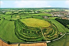


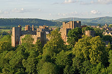


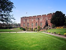


Shropshire (district)Shropshire (disambiguation)SaloopCeremonial countyLong MyndShrewsbury Market Hallthe Iron BridgeIronbridgeSovereign stateUnited KingdomConstituent countryEnglandRegionWest MidlandsAncientTime zoneList of MPsWest Mercia PoliceCeremonial countyLord LieutenantHigh Sheriff13th of 4841st of 48Shropshire UAUnitary authoritiesShropshire CouncilTelford and Wrekin CouncilDistrictsShropshireTelford and Wrekinborder with WalesCheshireStaffordshireWorcestershireHerefordshireWrexhamTelfordShrewsburycounty townmarket townsOswestryMarket DraytonBridgnorthLudlowlocal governmenthistoricallylarge exclaveHalesowenOldburyShropshire HillsStiperstonesClee HillsWenlock Edgethe Wrekinnational landscapeClun ForestOswestry uplandsWixall Mossnational nature reservesandstone plateauSevernNeolithicBronze AgeShropshire bullahillfortOld OswestryIron AgeViroconium CornoviorumAnglo-SaxonMerciaHigh Middle AgesWelsh MarchesCouncil of Wales and the MarchesEnglish Civil WarRoyalistCharles IIoak treeBattle of WorcesterCoalbrookdaleIndustrial RevolutionWorld Heritage SiteHistory of ShropshireSuttonMitchel's FoldStapeley HillMitchell's FoldCornoviiCeltichill fortKing Arthur’sGuinevereStonehengeViroconiumCaracticusPtolemyWroxeterRoman ruleHollandophyton, the extinct plantsKingdom of PowysBrochwel YsgithrogOswald of NorthumbriamiraclesKing Offatwo dykesSt ChadOffa's DykeVikingsChirburySt AlkmundÆthelflædAlfred the GreatNorman conquestRoger de MontgomerieRobert de BellêmeLudlow CastleShrewsbury CastleDiocese of HerefordCoventry and LichfieldDiocese of St. AsaphdisestablishmentChurch in WalesMarcher LordsEarls of MarchKing Henry VIPrince EdwardCornwall