Larsen Ice Shelf
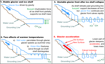
It is named after Captain Carl Anton Larsen, the master of the Norwegian whaling vessel Jason, who sailed along the ice front as far as 68°10' South during December 1893.[6] The ice shelf originally covered an area of 85,000 square kilometres (33,000 sq mi), but following the disintegration in the north and the break away of iceberg A-17[failed verification (See discussion.U.S. Antarctic Program scientists were in the north-western Weddell Sea investigating the sediment record in a deep glacial trough of roughly 1,000,000 square kilometres (390,000 sq mi) (twice the size of Texas or France).[9] Data collected in 2007 by an international team of investigators through satellite-based radar measurements suggests that the overall ice-sheet mass balance in Antarctica is increasingly negative.[3] From 31 January 2002 to March 2002 the Larsen B sector partially collapsed and parts broke up, 3,250 km2 (1,250 sq mi) of ice 220 m (720 ft) thick, an area comparable to the US state of Rhode Island.[15] It broke over a period of three weeks or less, with a factor in this fast break-up being the powerful effects of water; ponds of meltwater formed on the surface during the near 24 hours of daylight in the summertime, flowed down into cracks and, acting like a multitude of wedges, levered the shelf apart.[30] In June 2017 the speed of the imminent Larsen C iceberg accelerated, with the eastern end moving at 10 metres (33 ft) per day away from the main shelf.[31] As discussed by the Project MIDAS researchers on their site: "In another sign that the iceberg calving is imminent, the soon-to-be-iceberg part of Larsen C ice shelf has tripled in speed to more than 10 meters per day between 24 and 27 June 2017.[37][38] Project MIDAS updated their blog information on 19 July 2017 regarding Larsen C by revealing that a possible new rift appeared to be extending northwards from the point where A-68 had broken off in mid-July.Over roughly the past fifty years it has advanced (expanded) whereas comparable George VI, Bach, Stange, and Larsen C ice shelves have retreated (to a much greater net extent).


Ice shelfAntarctic PeninsulaWeddell SeaEtymologyCarl Anton LarsenCape LongingSmith PeninsulaembaymentsAntarcticaU.S. Antarctic ProgramFranceMethanehydrogen sulfidecold seepsAntarctic CircleinterglacialCrane GlacierRhode IslandicebergcalvingThe IndependentFaraday stationanthropogenicglobal warmingHolocenesea iceembaymentfresh-waterglacial iceice packScar Inlet Ice ShelfIceberg A-68DelawareLuxembourglargest icebergs ever recordedAdrian LuckmanSentinel-1global sea levelsGipps Ice RiseGeorge VIStangeSentinel-1BGlacial motionList of Antarctic ice shelvesLarsen InletSea level riseBibcodeDomack, EugeneAmerican Association for the Advancement of ScienceGeophysical Research LettersPearce, FredUniversity of Colorado at BoulderJet Propulsion LaboratoryUSA TodayUnited States Geological SurveyWayback Machine