Kostanay Region
The region is characterized of flat relief with inflows of the Ayat, Ubagan, Ui, and Turgay, Saryozen, and Karatorgai rivers.The Northern part occupies the southeast suburb of the West-Siberian lowland, the Turgay Plateau trails in from the south, the Zaural plateu comes from the west, and the Kazakh Uplands comes in from the southwest.The Kostanay Region has more than 5,000 lakes; the largest ones are located in Torgai dell, Kushmurun, Sarymoin, Aksuat, and Sarykopa.[citation needed] The bowels are especially rich in iron ore, brown coal, asbestos, fire-resistant brick clay, flux, cement limestone, glass sand, building stones, among others.[6] According to the Journal of Archaeological Science, in July 2020, scientists from South Ural State University studied two Late Bronze Age horses with the aid of radiocarbon dating from Kurgan 5 of the Novoilinovsky 2 cemetery in the Lisakovsk city.[7] "It is likely that militarized elite, whose power was based on the physical control of fellow tribesmen and neighbors with the help of riding and fighting skills, was buried in the Novoilinovsky-2 burial ground.There may be another explanation: These elite fulfilled the function of mediating conflicts within the collective, and therefore had power and high social status.[10] Ethnic groups (2020):[11] The region is administratively divided into sixteen districts and the cities of Kostanay, Arkalyk, Lisakovsk, and Rudny.On territory of area pass from the north on the south and a southeast the main transit roads connecting the regional center with cities of Kazakhstan: Nur-Sultan, Almaty and adjoining areas; Urals: Chelyabinsk, Magnitogorsk, Troitsk, Ekaterinburg; Western Siberia: Kurgan, Tyumen.Operation length of railways of general purpose, which are taking place on territory of the region, is equal to 1048 km.From the international airport of Kostanay regular and charter flights in many cities of Kazakhstan, the CIS, Germany (Frankfurt on Main, Düsseldorf, Hamburg, Stuttgart), to Arab Emirates, Turkey and others are carried out.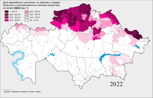
|
The share of the European population by districts and cities of regional and republican subordination Kazakhstan in 2022
> 70٪
60.0 – 69.9 %
50.0 - 59.9 %
40.0 - 49.9 %
30.0 - 39.9 %
20.0 - 29.9 %
10.0 - 19.9 %
0.0 - 9.9 %
|
KazakhRussianRegionNaurzum Nature ReserveKostanayArkalykCountryKazakhstanCapitalTime zonePostal codesArea codesISO 3166 codeVehicle registrationDistrictsCitiesTownshipsVillagesromanizedfederal subjectsOrenburg OblastChelyabinsk OblastKurgan OblastUral MountainsAktobe RegionKaraganda RegionAkmola RegionNorth Kazakhstan RegionTobol (Tobyl) RiverIrtysh RivermammalfishesTurgaySaryozenTurgay PlateauKazakh UplandsKushmurunAksuatSarykopaSovietVirgin Lands Campaigniron orebrown coalbauxitesilvernickelJournal of Archaeological ScienceSouth Ural State UniversityLate Bronze Ageradiocarbon datingLisakovskstallionUkrainianGermanAltynsarin DistrictAmangeldi DistrictAmangeldiAuliekol DistrictAuliekolDenisov DistrictFyodorov DistrictFyodorovkaKamysty DistrictKamystyKarabalyk DistrictKarasu DistrictKarasuKostanay DistrictMendykara DistrictBorovskoyNauyrzym DistrictKaramendySarykol DistrictTaran DistrictUzunkol DistrictZhangeldi DistrictTorgayZhitikara DistrictZhitikaraZhetikaraAkhmet BaytursinuliNur-SultanAlmatyChelyabinskMagnitogorskTroitskEkaterinburgKurganTyumenBoeingairport of KostanayGermanyFrankfurt on MainDüsseldorfHamburgStuttgartArab EmiratesTurkeyRussian Federationhydropathic establishmentsgastrointestinal tractrespiratory systemmud bathsKamshat DonenbaevaRussian irredentismRussian imperialismBibcodeRussiaAltynsarinDenisovFyodorovKarabalykMendykaraNauyrzymSarykolUzunkolZhangeldiRegions of KazakhstanAkmolaAktobeAtyrauEast KazakhstanJambylJetisuKaragandaKyzylorda