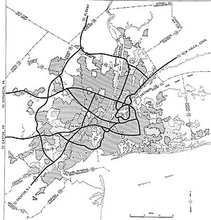
Interstate 280 (New Jersey)
The western part of the route runs through suburban areas of Morris and Essex counties, crossing the Watchung Mountains.I-280 begins at the interchange with I-80 and US 46 in Parsippany–Troy Hills, Morris County, and heads southeast into wooded surroundings as a four-lane freeway.[1] The freeway runs near some fields before heading back into woods and entering Roseland, Essex County, at the crossing of the Passaic River.[1] At this point, the roadway widens to six lanes and runs near wooded suburban areas, passing over the Morristown and Erie Railway's Whippany Line before reaching CR 527 at another cloverleaf interchange.After Prospect Avenue (CR 577), I-280 makes a sharp turn to the south and goes through the First Watchung Mountain in another cut, resuming into suburbs again and heading south-southeast as it intersects Mt.Here, I-280 narrows back to six lanes and heads onto a depressed alignment with frequent overpasses, running a short distance to the south of NJ Transit's Morristown Line.As the road returns to surface level and begins to parallel NJ Transit's Morris & Essex Lines and Montclair-Boonton Line to the north, an unused bridge carries the western end of the 1954 section of freeway over the railroad to Orange Street east of Duryea Street.Past CR 508, the freeway narrows to four lanes and comes to the toll plaza for the New Jersey Turnpike (I-95) at exit 15W, at which point I-280 ends.Much of the material that was excavated from this section of I-280 and east was removed via a temporary rail line that was built in the center of the right-of-way west to Interstate 80.[15][16] The construction of I-280 destroyed a large part of the historic urban cores of Orange, East Orange, and Newark, while providing a path for shoppers to head to shopping malls in surrounding suburban communities rather than shop in aging downtowns that had been disrupted by the highway construction.In 2001, the state determined the Stickel Bridge over the Passaic River and its approaches were structurally deficient and was going to need to be replaced after sections of it were falling apart.


Parsippany–Troy HillsG.S. ParkwayEast OrangeRoute 21NewarkI-95 TollN.J. TurnpikeKearnyUnited StatesNew JerseyMorrisHudsonInterstate Highway SystemAuxiliarySuffixedBusinessFutureNew Jersey State Highway RoutesInterstateScenic BywaysRoute 284Interstate HighwayMorris CountyNew Jersey TurnpikeHudson CountyHolland TunnelLincoln TunnelNew York CityWatchung MountainsThe Orangesvertical-lift bridgeWilliam A. Stickel Memorial BridgePassaic RiverEast NewarkHarrisonGarden State ParkwayRoute 25ARoute 25US Route 1/9Jersey CityRoute 58Route 3New Jersey State Highway DepartmentInterstate 78US 46Whippany RiverEast Hanover TownshipRoselandEssex Countycloverleaf interchangeEisenhower ParkwayMorristown and Erie RailwayCR 527LivingstonCR 634West OrangeSecond Watchung MountainCR 636CR 577First Watchung MountainCR 660OrangeNJ TransitMorristown LineBrick Church stationEast Orange stationCR 509Newark Light RailMorris & Essex LinesMontclair-Boonton LineCR 508New Jersey MeadowlandsRoute 7US 1/9 TruckRoute 139Route 495New Jersey Route 58US 1/91953 New Jersey state highway renumberingRoute 10Bureau of Public Roadsright-of-wayVictoriancall boxesNew Jersey Department of TransportationPATH stationSports Illustrated StadiumDelaware Water GapMahwahMorristownCR 609CR 527The CaldwellsCR 634CR 636MillburnVeronaCR 577Cedar GroveCR 660MontclairCR 508South OrangeBranch Brook ParkBroad Street StationRutgers UniversityBellevilleTrentonSecaucusTolledRoute 25ADGoogle MapsThe New York TimesFindLawWikisourceNew Jersey State AssemblyJacobs, AndrewState Farm InsuranceRand McNallyThe Press of Atlantic CityThe Star-LedgerMeasuringWorthGross Domestic Product deflatorAuxiliary routesInterstate 80California